
Previsão:

Previsão de curto prazoprincipalmente seco. Warm (máx. 20°C na Terça à tarde, mín 17°C na Terça à noite). o vento será geralmente fraco. | ||||||||||||||||||||||||
Ter 14 | Quarta-feira 15 | Quinta-feira 16 | Sex 17 | |||||||||||||||||||||
4 PM | 7 PM | 10 PM | 1 AM | 4 AM | 7 AM | 10 AM | 1 PM | 4 PM | 7 PM | 10 PM | 1 AM | 4 AM | 7 AM | 10 AM | 1 PM | 4 PM | 7 PM | 10 PM | 1 AM | 4 AM | 7 AM | 10 AM | 1 PM | |
Mapa da altura do Swell | 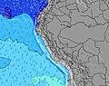 |  | 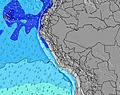 | 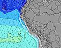 |  | 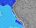 | 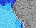 | 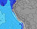 | 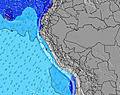 | |||||||||||||||
Swell Altura (m) Direção Período (s) | SW 14 | SW 14 | SW 14 | SW 13 | SW 13 | SW 13 | SW 13 | SW 12 | SW 12 | SW 13 | SW 13 | SW 13 | SW 13 | SW 13 | SW 13 | SW 13 | SW 13 | SW 13 | SW 13 | SW 12 | SW 12 | SW 12 | SW 12 | SW 12 |
Onda Gráfico | ||||||||||||||||||||||||
404 | 500 | 465 | 437 | 437 | 431 | 459 | 437 | 444 | 473 | 488 | 437 | 431 | 431 | 437 | 437 | 494 | 486 | 486 | 398 | 386 | 347 | 347 | 297 | |
Vento (km/h) | ||||||||||||||||||||||||
Estado do Vento maral cruzado-maral Cruzado cruzado-terral terral cristalino | cross-off | cross-off | cross-off | cross-off | cross-off | cross-off | cross | cross | cross | cross-off | cross-off | cross-off | cross-off | glassy | cross | cross | cross-off | cross-off | cross-off | cross-off | cross-off | cross-off | cross-off | cross |
Maré Alta | 5:10PM0.61m | 6:32AM1.11m | 6:08PM0.62m | 7:19AM1.11m | 7:07PM0.63m | 8:04AM1.07m | ||||||||||||||||||
Maré Baixa | 11:22PM-0.05m | 1:07PM0.25m | 00:12AM-0.02m | 1:55PM0.23m | 1:01AM0.04m | |||||||||||||||||||
— | — | — | — | 6:28 | — | — | — | — | — | — | — | 6:28 | — | — | — | — | — | — | — | 6:28 | — | — | — | |
6:00 | — | — | — | — | — | — | — | 6:00 | — | — | — | — | — | — | — | 6:00 | — | — | — | — | — | — | 6:00 | |
mm | — | — | — | — | — | — | — | — | — | — | — | — | — | — | — | — | — | — | — | — | — | — | — | — |
Temp. °C | 20 | 18 | 18 | 17 | 18 | 18 | 20 | 20 | 20 | 18 | 18 | 18 | 18 | 18 | 19 | 20 | 20 | 18 | 18 | 18 | 17 | 17 | 18 | 20 |
Ressent. °C | 20 | 18 | 18 | 17 | 18 | 18 | 21 | 19 | 20 | 18 | 18 | 19 | 19 | 19 | 19 | 19 | 20 | 18 | 18 | 19 | 18 | 18 | 18 | 19 |
Swell 1 Altura (m) Direção Período (s) | SW 14 | SW 14 | SW 14 | SW 13 | SW 13 | SW 13 | SW 13 | SW 12 | SW 12 | SW 13 | SW 13 | SW 13 | SW 13 | SW 13 | SW 13 | SW 13 | SW 13 | SW 13 | SW 13 | SW 12 | SW 12 | SW 12 | SW 12 | SW 12 |
404 | 500 | 465 | 437 | 437 | 431 | 459 | 437 | 444 | 473 | 488 | 437 | 431 | 431 | 437 | 437 | 494 | 486 | 486 | 398 | 386 | 347 | 347 | 297 | |
Swell 2 Altura (m) Direção Período (s) | WSW 9 | WSW 9 | WSW 9 | WSW 9 | W 12 | W 12 | W 12 | NW 12 | W 12 | NW 12 | NW 12 | W 12 | W 12 | W 12 | W 12 | W 12 | W 11 | SW 16 | W 11 | S 4 | SW 20 | SW 20 | SW 19 | W 11 |
8 | 8 | 8 | 7 | 3 | 3 | 3 | 6 | 3 | 6 | 6 | 3 | 3 | 3 | 3 | 3 | 3 | 66 | 2 | 2 | 16 | 15 | 15 | 2 | |
Swell 3 Altura (m) Direção Período (s) | W 13 | W 13 | — | — | NW 12 | — | — | NW 12 | — | — | — | — | — | — | — | W 22 | W 22 | W 11 | — | W 11 | W 11 | W 11 | S 6 | S 6 |
3 | 3 | — | — | 6 | — | — | 6 | — | — | — | — | — | — | — | 9 | 9 | 2 | — | 2 | 2 | 2 | 1 | 1 | |
Ondas de vento Altura (m) Direção Período (s) | SSW 7 | — | — | SSW 4 | SSW 4 | SSW 4 | — | — | — | — | — | — | — | — | S 4 | — | — | — | S 3 | — | S 4 | S 4 | S 4 | SSW 3 |
17 | — | — | 3 | 5 | 3 | — | — | — | — | — | — | — | — | 1 | — | — | — | 4 | — | 2 | 2 | 2 | 2 | |
Terral ou glassy mais perto | ||||||||||||||||||||||||
Distância (km) | 0 | 0 | 0 | 0 | 0 | 0 | 53 | 53 | 71 | 0 | 0 | 0 | 0 | 0 | 53 | 53 | 0 | 0 | 0 | 0 | 0 | 0 | 0 | 71 |
Melhor previsões de ondas em Lima | ||||||||||||||||||||||||
Melhor previsões de ondas em Peru | ||||||||||||||||||||||||
Buscador de Ondas Global | ||||||||||||||||||||||||
- Map Icons:
 Break
Break Live Wave Height (m)
 Live Wind Speed (km/h)
 Surf Rating (10 Max)
 Ocean Swells (m)
- Wind Speed (km/h)
widget de graça do Surf-Forecast.com para o seu site
O relatório de surf / widget do tempo abaixo está disponível para incorporar em sites de terceiros gratuitamente e fornece um resumo das nossas Chancay surf tempo. Simplesmente pegar o trecho de código html que fornecemos e colá-lo em seu próprio site. Você pode escolher seu idioma preferido e unidades métrico/imperial para o surf tempo de alimentação para atender aos usuários do seu site.... Clique aqui para adquirir o código.
 Nearest