
Previsão:

Previsão de curto prazochuviscos (total 3mm), principalmente caindo na Quarta à tarde. Warm (máx. 25°C na Terça de manhã, mín 22°C na Seg à noite). o vento será geralmente fraco. | ||||||||||||||||||||
Seg 27 | Terça-feira 28 | Quarta-feira 29 | ||||||||||||||||||
1 PM | 4 PM | 7 PM | 10 PM | 1 AM | 4 AM | 7 AM | 10 AM | 1 PM | 4 PM | 7 PM | 10 PM | 1 AM | 4 AM | 7 AM | 10 AM | 1 PM | 4 PM | 7 PM | 10 PM | |
Mapa da altura do Swell |  | 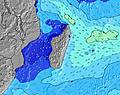 | 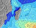 | 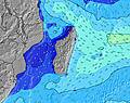 | 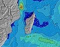 | 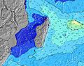 | 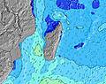 | 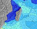 | ||||||||||||
Swell Altura (m) Direção Período (s) | SW 16 | SW 16 | SW 16 | SW 16 | SW 15 | SW 15 | SW 15 | SW 14 | SSW 19 | SSW 18 | SSW 17 | SSW 16 | SSW 16 | SSW 16 | SSW 15 | SSW 14 | SSW 14 | SSW 14 | SSW 14 | SSW 14 |
Onda Gráfico | ||||||||||||||||||||
3137 | 3098 | 2832 | 2796 | 2356 | 1140 | 940 | 1426 | 1344 | 1536 | 2705 | 2573 | 2447 | 2355 | 2147 | 2061 | 1772 | 1601 | 1442 | 1178 | |
Vento (km/h) | ||||||||||||||||||||
Estado do Vento maral cruzado-maral Cruzado cruzado-terral terral cristalino | glassy | glassy | cross-off | cross | cross-off | cross-off | cross-off | cross | cross-off | cross-off | cross-off | cross-off | cross | cross | cross | cross-off | cross-off | cross-off | cross-off | cross |
Maré Alta | 12:35PM0.52m | 11:56PM0.61m | 12:56PM0.55m | 00:25AM0.64m | 1:18PM0.58m | |||||||||||||||
Maré Baixa | 6:02PM0.24m | 6:34AM0.06m | 6:30PM0.22m | 7:01AM0.04m | 6:57PM0.20m | |||||||||||||||
— | — | — | — | — | 6:41 | — | — | — | — | — | — | — | 6:41 | — | — | — | — | — | — | |
— | 5:51 | — | — | — | — | — | — | — | 5:51 | — | — | — | — | — | — | — | 5:51 | — | — | |
mm | — | — | — | — | — | — | — | — | — | — | — | — | — | — | — | — | — | 1 | — | — |
Temp. °C | 24 | 23 | 23 | 22 | 22 | 22 | 22 | 23 | 25 | 24 | 23 | 22 | 22 | 22 | 22 | 24 | 25 | 24 | 23 | 23 |
Ressent. °C | 25 | 24 | 24 | 23 | 23 | 23 | 23 | 23 | 25 | 24 | 24 | 22 | 23 | 23 | 23 | 25 | 26 | 25 | 24 | 24 |
Swell 1 Altura (m) Direção Período (s) | SW 16 | SW 16 | SW 16 | SW 16 | SW 15 | SW 15 | SW 15 | SW 14 | SW 14 | SSW 18 | SSW 17 | SSW 16 | SSW 16 | SSW 16 | SSW 15 | SSW 14 | SSW 14 | SSW 14 | SSW 14 | SSW 14 |
3137 | 3098 | 2832 | 2796 | 2356 | 1140 | 940 | 1426 | 928 | 1536 | 2705 | 2573 | 2447 | 2355 | 2147 | 2061 | 1772 | 1601 | 1442 | 1178 | |
Swell 2 Altura (m) Direção Período (s) | SE 8 | SE 8 | SE 8 | ENE 10 | ENE 10 | SW 12 | SW 12 | SSW 19 | SSW 19 | SW 14 | SW 11 | SSW 10 | SSW 10 | SSW 10 | SSW 9 | ESE 11 | ESE 10 | NE 10 | NE 6 | NE 7 |
33 | 35 | 35 | 20 | 20 | 448 | 488 | 847 | 1344 | 676 | 258 | 204 | 168 | 148 | 92 | 64 | 62 | 50 | 20 | 22 | |
Swell 3 Altura (m) Direção Período (s) | E 10 | — | — | — | — | ENE 10 | SSW 20 | ENE 10 | SW 11 | SW 11 | — | ESE 12 | ESE 12 | — | ESE 11 | — | — | SW 22 | E 10 | E 10 |
18 | — | — | — | — | 20 | 317 | 20 | 224 | 303 | — | 78 | 77 | — | 65 | — | — | 18 | 8 | 8 | |
Ondas de vento Altura (m) Direção Período (s) | — | — | — | — | — | — | — | — | — | — | — | — | — | — | — | — | — | — | — | — |
— | — | — | — | — | — | — | — | — | — | — | — | — | — | — | — | — | — | — | — | |
Terral ou glassy mais perto | ||||||||||||||||||||
Distância (km) | 0 | 0 | 0 | 1 | 0 | 0 | 0 | 1 | 0 | 0 | 0 | 0 | 1 | 1 | 1 | 0 | 0 | 0 | 0 | 1 |
Melhor previsões de ondas em Mauritius | ||||||||||||||||||||
Melhor previsões de ondas em Mauritius | ||||||||||||||||||||
Buscador de Ondas Global | ||||||||||||||||||||
- Map Icons:
 Break
Break Live Wave Height (m)
 Live Wind Speed (km/h)
 Surf Rating (10 Max)
 Ocean Swells (m)
- Wind Speed (km/h)
widget de graça do Surf-Forecast.com para o seu site
O relatório de surf / widget do tempo abaixo está disponível para incorporar em sites de terceiros gratuitamente e fornece um resumo das nossas Tamarin Bay surf tempo. Simplesmente pegar o trecho de código html que fornecemos e colá-lo em seu próprio site. Você pode escolher seu idioma preferido e unidades métrico/imperial para o surf tempo de alimentação para atender aos usuários do seu site.... Clique aqui para adquirir o código.
 Nearest