
Previsão:

Previsão de curto prazoprincipalmente seco. Warm (máx. 23°C na Terça de manhã, mín 11°C no Domingo à noite). o vento será geralmente fraco. | ||||||||||||||||||||||
Domingo 2 | Segunda-feira 3 | Terça-feira 4 | ||||||||||||||||||||
8 AM | 11 AM | 2 PM | 5 PM | 8 PM | 11 PM | 2 AM | 5 AM | 8 AM | 11 AM | 2 PM | 5 PM | 8 PM | 11 PM | 2 AM | 5 AM | 8 AM | 11 AM | 2 PM | 5 PM | 8 PM | 11 PM | |
Mapa da altura do Swell |  | 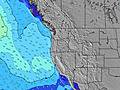 | 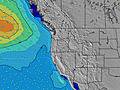 | 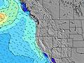 |  |  | 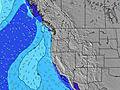 | 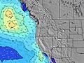 | ||||||||||||||
Swell Altura (m) Direção Período (s) | WNW 9 | WNW 9 | WNW 9 | WNW 9 | WNW 9 | WNW 9 | WNW 8 | WNW 8 | NW 8 | NW 8 | NW 7 | NW 6 | NNW 7 | NNW 7 | NNW 7 | NW 7 | NW 7 | NW 7 | NW 7 | NW 7 | NW 7 | NNW 7 |
Onda Gráfico | ||||||||||||||||||||||
363 | 436 | 484 | 397 | 405 | 372 | 351 | 232 | 304 | 257 | 295 | 278 | 361 | 384 | 363 | 303 | 287 | 295 | 295 | 365 | 452 | 440 | |
Vento (km/h) | ||||||||||||||||||||||
Estado do Vento maral cruzado-maral Cruzado cruzado-terral terral cristalino | glassy | cross-on | cross-on | cross | cross | cross | cross-off | cross-off | cross-off | cross | cross | cross | cross | cross-off | cross-off | cross-off | cross-off | cross | cross | cross | cross | cross |
Maré Alta | 3:58PM1.83m | 3:43AM1.64m | 4:29PM1.90m | 4:40AM1.49m | 5:04PM1.95m | |||||||||||||||||
Maré Baixa | 9:50AM0.04m | 10:23PM0.42m | 10:21AM0.18m | 11:16PM0.34m | 10:55AM0.34m | |||||||||||||||||
6:01 | — | — | — | — | — | — | 6:03 | — | — | — | — | — | — | — | 6:03 | — | — | — | — | — | — | |
— | — | — | — | 8:40 | — | — | — | — | — | — | — | 8:39 | — | — | — | — | — | — | — | 8:38 | — | |
mm | — | — | — | — | — | — | — | — | — | — | — | — | — | — | — | — | — | — | — | — | — | — |
Temp. °C | 14 | 17 | 17 | 16 | 15 | 13 | 12 | 11 | 13 | 19 | 20 | 19 | 16 | 15 | 15 | 15 | 18 | 23 | 23 | 22 | 17 | 15 |
Ressent. °C | 14 | 15 | 14 | 11 | 11 | 10 | 10 | 9 | 11 | 16 | 16 | 15 | 13 | 13 | 13 | 12 | 16 | 20 | 20 | 19 | 15 | 13 |
Swell 1 Altura (m) Direção Período (s) | WNW 9 | WNW 9 | WNW 9 | WNW 9 | WNW 9 | WNW 9 | WNW 8 | WNW 8 | NW 8 | SW 13 | SW 13 | SW 13 | SW 13 | WSW 16 | SW 16 | SW 16 | NW 7 | NW 7 | SW 16 | SW 16 | WNW 9 | WNW 9 |
363 | 436 | 484 | 397 | 405 | 372 | 351 | 232 | 304 | 44 | 27 | 27 | 27 | 25 | 41 | 41 | 287 | 295 | 40 | 64 | 35 | 35 | |
Swell 2 Altura (m) Direção Período (s) | SW 14 | SW 14 | SW 13 | SW 13 | SW 13 | SW 13 | SW 13 | SW 13 | SW 13 | WSW 18 | WSW 18 | WSW 17 | WSW 16 | SW 13 | SW 13 | SW 13 | SW 16 | WSW 16 | SSW 12 | SSW 12 | SW 15 | SW 15 |
92 | 89 | 88 | 63 | 63 | 45 | 45 | 44 | 44 | 30 | 30 | 29 | 26 | 26 | 26 | 25 | 41 | 25 | 15 | 14 | 60 | 57 | |
Swell 3 Altura (m) Direção Período (s) | SW 19 | SW 19 | SW 19 | SW 18 | WSW 18 | WSW 18 | WSW 18 | WSW 18 | WSW 18 | — | — | — | — | WSW 16 | SW 13 | — | SSW 12 | SSW 12 | NW 10 | — | SSW 12 | SW 12 |
15 | 15 | 14 | 13 | 31 | 31 | 31 | 31 | 31 | — | — | — | — | 25 | 26 | — | 15 | 15 | 4 | — | 14 | 6 | |
Ondas de vento Altura (m) Direção Período (s) | — | — | — | N 4 | N 5 | N 5 | NNE 5 | N 5 | — | NW 8 | NW 7 | NW 6 | NNW 7 | NNW 7 | NNW 7 | NW 7 | — | — | NW 7 | NW 7 | NW 7 | NNW 7 |
— | — | — | 25 | 53 | 36 | 33 | 49 | — | 257 | 295 | 278 | 361 | 384 | 363 | 303 | — | — | 295 | 365 | 452 | 440 | |
Terral ou glassy mais perto | ||||||||||||||||||||||
Distância (km) | 0 | 364 | 789 | 1223 | 789 | 360 | 0 | 0 | 0 | 215 | 271 | 386 | 437 | 3 | 0 | 0 | 0 | 215 | 271 | 350 | 335 | 21 |
Melhor previsões de ondas em North Oregon | ||||||||||||||||||||||
Melhor previsões de ondas em United States | ||||||||||||||||||||||
Buscador de Ondas Global | ||||||||||||||||||||||
- Map Icons:
 Break
Break Live Wave Height (m)
 Live Wind Speed (km/h)
 Surf Rating (10 Max)
 Ocean Swells (m)
- Wind Speed (km/h)
widget de graça do Surf-Forecast.com para o seu site
O relatório de surf / widget do tempo abaixo está disponível para incorporar em sites de terceiros gratuitamente e fornece um resumo das nossas Taft (Siltetz River) surf tempo. Simplesmente pegar o trecho de código html que fornecemos e colá-lo em seu próprio site. Você pode escolher seu idioma preferido e unidades métrico/imperial para o surf tempo de alimentação para atender aos usuários do seu site.... Clique aqui para adquirir o código.
 Nearest