
Previsão:

Previsão de curto prazoprincipalmente seco. Very mild (máx. 19°C na Terça à tarde, mín 12°C na Segunda de manhã). Ventos diminuem (ventos frescos de Noroeste no Domingo à noite, calmo na Quarta de manhã). | ||||||||||||||||||
Dom 2 | Segunda-feira 3 | Terça-feira 4 | ||||||||||||||||
8 PM | 11 PM | 2 AM | 5 AM | 8 AM | 11 AM | 2 PM | 5 PM | 8 PM | 11 PM | 2 AM | 5 AM | 8 AM | 11 AM | 2 PM | 5 PM | 8 PM | 11 PM | |
Mapa da altura do Swell |  | 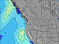 | 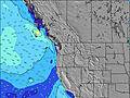 | 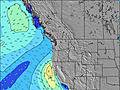 | 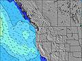 | 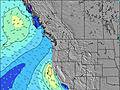 | 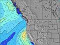 | |||||||||||
Swell Altura (m) Direção Período (s) | WNW 9 | WNW 8 | WNW 8 | WNW 8 | WNW 8 | WNW 7 | WNW 7 | WNW 7 | NW 7 | NW 6 | NW 6 | WNW 7 | WNW 7 | WNW 7 | WNW 7 | NW 7 | WNW 8 | NW 8 |
Onda Gráfico | ||||||||||||||||||
417 | 338 | 273 | 218 | 169 | 167 | 139 | 144 | 173 | 161 | 123 | 107 | 102 | 140 | 160 | 156 | 307 | 322 | |
Vento (km/h) | ||||||||||||||||||
Estado do Vento maral cruzado-maral Cruzado cruzado-terral terral cristalino | cross-on | cross | cross-off | glassy | glassy | on | cross-on | cross-on | cross-on | cross | cross-off | glassy | glassy | on | cross-on | cross-on | cross-on | cross-on |
Maré Alta | 3:48AM2.05m | 4:27PM2.30m | 4:40AM1.87m | 5:02PM2.35m | ||||||||||||||
Maré Baixa | 9:46PM0.41m | 9:49AM0.11m | 10:36PM0.32m | 10:25AM0.32m | ||||||||||||||
— | — | — | 5:56 | — | — | — | — | — | — | — | 5:58 | — | — | — | — | — | — | |
8:49 | — | — | — | — | — | — | — | 8:47 | — | — | — | — | — | — | — | 8:45 | — | |
mm | — | — | — | — | — | — | — | — | — | — | — | — | — | — | — | — | — | — |
Temp. °C | 14 | 13 | 13 | 13 | 12 | 14 | 17 | 16 | 16 | 16 | 15 | 15 | 15 | 17 | 18 | 19 | 16 | 16 |
Ressent. °C | 9 | 9 | 11 | 12 | 11 | 12 | 14 | 12 | 12 | 13 | 14 | 15 | 14 | 16 | 15 | 15 | 12 | 14 |
Swell 1 Altura (m) Direção Período (s) | SW 13 | SW 13 | WNW 8 | WNW 8 | WNW 8 | WNW 7 | WNW 7 | SW 13 | SW 13 | SW 13 | NW 6 | WNW 7 | WNW 7 | WNW 7 | WNW 7 | WNW 9 | SW 16 | SW 16 |
88 | 63 | 273 | 218 | 169 | 167 | 139 | 44 | 43 | 26 | 123 | 107 | 102 | 140 | 160 | 48 | 64 | 61 | |
Swell 2 Altura (m) Direção Período (s) | SW 18 | WSW 18 | SW 13 | SW 13 | SW 13 | SW 13 | SW 13 | WSW 18 | WSW 17 | WSW 16 | SW 13 | WSW 16 | SW 16 | SW 16 | WNW 9 | SW 16 | SSW 12 | SW 12 |
13 | 31 | 63 | 62 | 62 | 61 | 61 | 30 | 29 | 26 | 26 | 51 | 66 | 66 | 29 | 65 | 15 | 6 | |
Swell 3 Altura (m) Direção Período (s) | — | WSW 18 | WSW 18 | WSW 18 | WSW 18 | WSW 18 | WSW 18 | S 12 | — | — | SW 16 | SW 13 | SW 13 | SW 13 | SW 16 | SW 12 | S 12 | S 14 |
— | 31 | 31 | 61 | 61 | 31 | 30 | 3 | — | — | 66 | 26 | 26 | 26 | 65 | 24 | 3 | 4 | |
Ondas de vento Altura (m) Direção Período (s) | WNW 9 | WNW 8 | — | — | — | — | — | WNW 7 | NW 7 | NW 6 | — | — | — | — | — | NW 7 | WNW 8 | NW 8 |
417 | 338 | — | — | — | — | — | 144 | 173 | 161 | — | — | — | — | — | 156 | 307 | 322 | |
Terral ou glassy mais perto | ||||||||||||||||||
Distância (km) | 890 | 98 | 0 | 0 | 0 | 37 | 117 | 124 | 126 | 117 | 0 | 0 | 0 | 42 | 7 | 124 | 599 | 115 |
Melhor previsões de ondas em Washington State | ||||||||||||||||||
Melhor previsões de ondas em United States | ||||||||||||||||||
Buscador de Ondas Global | ||||||||||||||||||
- Map Icons:
 Break
Break Live Wave Height (m)
 Live Wind Speed (km/h)
 Surf Rating (10 Max)
 Ocean Swells (m)
- Wind Speed (km/h)
widget de graça do Surf-Forecast.com para o seu site
O relatório de surf / widget do tempo abaixo está disponível para incorporar em sites de terceiros gratuitamente e fornece um resumo das nossas Point Grenville surf tempo. Simplesmente pegar o trecho de código html que fornecemos e colá-lo em seu próprio site. Você pode escolher seu idioma preferido e unidades métrico/imperial para o surf tempo de alimentação para atender aos usuários do seu site.... Clique aqui para adquirir o código.
 Nearest