
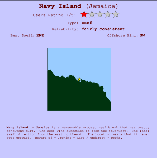
Navy Island Surf Guide
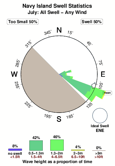
Navy Island in Jamaica is a fairly exposed reef break that has fairly consistent surf. Works best in offshore winds from the southwest. The ideal swell direction from the east northeast. Even when the surf is up, crowds are unknown. Hazards include - Urchins - Rips / undertow - Rocks.
Navy Island Spot Info
| Type: | Rating: | Reliability: | Todays Sea Temp*: |
|---|---|---|---|
| fairly consistent | 29.1°C*ocean temperature recorded from satellite |
Surfing Navy Island:
The best conditions reported for surf at Navy Island occur when a East-northeast swell combines with an offshore wind direction from the Southwest.
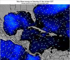
Previsão da Energia de Ondas (Força): 12hrs
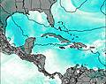

Navy Island Surf:
Monday, 20 July 2026, 16:03 Local time| Segunda-feira 20 | Ter | |||
| 4PM | 7PM | 10PM | 1AM | |
| Wave (m) | ||||
| Período (s) | 6 | 8 | 8 | 8 |
| Vento (km/h) | ||||
| Estado do Vento | cross- on |
cross | cross | cross |
- /breaks/Navy-Island/forecasts/latest
Navy Island Surf Guide
Navy Island in Jamaica is a fairly exposed reef break that has fairly consistent surf. Works best in offshore winds from the southwest. The ideal swell direction from the east northeast. Even when the surf is up, crowds are unknown. Hazards include - Urchins - Rips / undertow - Rocks.
Navy Island Spot Info
Type: Rating: Reliability: Todays Sea Temp*:  Reef
Reef 1
1fairly consistent 29.1°C*ocean temperature recorded from satelliteSurfing Navy Island:
The best conditions reported for surf at Navy Island occur when a East-northeast swell combines with an offshore wind direction from the Southwest.
Previsão da Energia de Ondas (Força): 12hrs
Use a aba navegação acima para ver temperatura do mar em Navy Island, fotografias de Navy Island, previsões detalhadas do swell em Navy Island, previsões do vento e do tempo, webcams em Navy Island , vento atual em Jamaica com base em dados ao vivo fornecidos por estações de meteorologia e previsões da maré em Navy Island. O link para os mapas do swell em Jamaica abrirá uma imagem ampliada monstrando Jamaica e os mares próximos. Estes mapas do swell podem ser animados para mostrar diferentes componentes do swell, energia das ondas, período das ondas, altura das ondas, assim como previsões do vento e do tempo, observações em tempo real do estado do tempo e do mar graças às bóias de Jamaica, navios passantes e estações de meteorologia presentes na costa. Cada uma das páginas de previsão para este surf break apresenta as ferramentas do buscador global e regional para localizar as melores condições de surf na área ao redor de Navy Island.
Navy Island Surf:
Monday, 20 July 2026, 16:03 Local timeSegunda-feira 20 Ter 4PM 7PM 10PM 1AM Wave (m) Período (s) 6 8 8 8 Vento (km/h) Estado do Vento cross-
oncross cross cross - /breaks/Navy-Island/forecasts/latest
- /breaks/Navy-Island/forecasts/latest/six_day
Navy Island Surf Guide
Navy Island in Jamaica is a fairly exposed reef break that has fairly consistent surf. Works best in offshore winds from the southwest. The ideal swell direction from the east northeast. Even when the surf is up, crowds are unknown. Hazards include - Urchins - Rips / undertow - Rocks.
Navy Island Spot Info
Type: Rating: Reliability: Todays Sea Temp*: Reef1fairly consistent 29.1°C*ocean temperature recorded from satelliteSurfing Navy Island:
The best conditions reported for surf at Navy Island occur when a East-northeast swell combines with an offshore wind direction from the Southwest.
Previsão da Energia de Ondas (Força): 12hrs
Use a aba navegação acima para ver temperatura do mar em Navy Island, fotografias de Navy Island, previsões detalhadas do swell em Navy Island, previsões do vento e do tempo, webcams em Navy Island , vento atual em Jamaica com base em dados ao vivo fornecidos por estações de meteorologia e previsões da maré em Navy Island. O link para os mapas do swell em Jamaica abrirá uma imagem ampliada monstrando Jamaica e os mares próximos. Estes mapas do swell podem ser animados para mostrar diferentes componentes do swell, energia das ondas, período das ondas, altura das ondas, assim como previsões do vento e do tempo, observações em tempo real do estado do tempo e do mar graças às bóias de Jamaica, navios passantes e estações de meteorologia presentes na costa. Cada uma das páginas de previsão para este surf break apresenta as ferramentas do buscador global e regional para localizar as melores condições de surf na área ao redor de Navy Island.
Navy Island Surf:
Monday, 20 July 2026, 16:03 Local timeSegunda-feira 20 Ter 4PM 7PM 10PM 1AM Wave (m) Período (s) 6 8 8 8 Vento (km/h) Estado do Vento cross-
oncross cross cross - /breaks/Navy-Island/forecasts/latest
Navy Island Surf Guide
Navy Island in Jamaica is a fairly exposed reef break that has fairly consistent surf. Works best in offshore winds from the southwest. The ideal swell direction from the east northeast. Even when the surf is up, crowds are unknown. Hazards include - Urchins - Rips / undertow - Rocks.
Navy Island Spot Info
Type: Rating: Reliability: Todays Sea Temp*: Reef1fairly consistent 29.1°C*ocean temperature recorded from satelliteSurfing Navy Island:
The best conditions reported for surf at Navy Island occur when a East-northeast swell combines with an offshore wind direction from the Southwest.
Previsão da Energia de Ondas (Força): 12hrs
Use a aba navegação acima para ver temperatura do mar em Navy Island, fotografias de Navy Island, previsões detalhadas do swell em Navy Island, previsões do vento e do tempo, webcams em Navy Island , vento atual em Jamaica com base em dados ao vivo fornecidos por estações de meteorologia e previsões da maré em Navy Island. O link para os mapas do swell em Jamaica abrirá uma imagem ampliada monstrando Jamaica e os mares próximos. Estes mapas do swell podem ser animados para mostrar diferentes componentes do swell, energia das ondas, período das ondas, altura das ondas, assim como previsões do vento e do tempo, observações em tempo real do estado do tempo e do mar graças às bóias de Jamaica, navios passantes e estações de meteorologia presentes na costa. Cada uma das páginas de previsão para este surf break apresenta as ferramentas do buscador global e regional para localizar as melores condições de surf na área ao redor de Navy Island.
Navy Island Surf:
Monday, 20 July 2026, 16:03 Local timeSegunda-feira 20 Ter 4PM 7PM 10PM 1AM Wave (m) Período (s) 6 8 8 8 Vento (km/h) Estado do Vento cross-
oncross cross cross Tide Times:
Para Port Antonio %{dist} %{km} de %{location}
A PRÓXIMA É ÀS (hora local) faltam maré alta maré baixa Navy Island Tide Times and Tide Chart
Live Weather:
At SHIP3058, 46 km from Navy Island.
- Air temperature
30.1°COverall Navy Island Surf Consistency and Wind Distribution in Julho
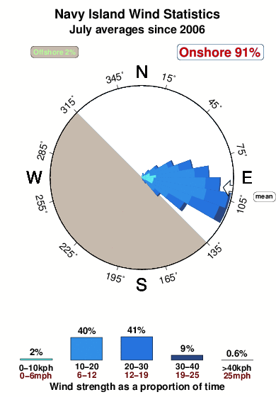


Wind stats for Navy Island: see the variation in direction and stength by month.
fotos da galeria
Contornos: Estradas & Rios: Escolha um spot de surf da lista 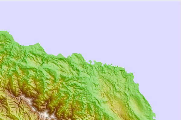
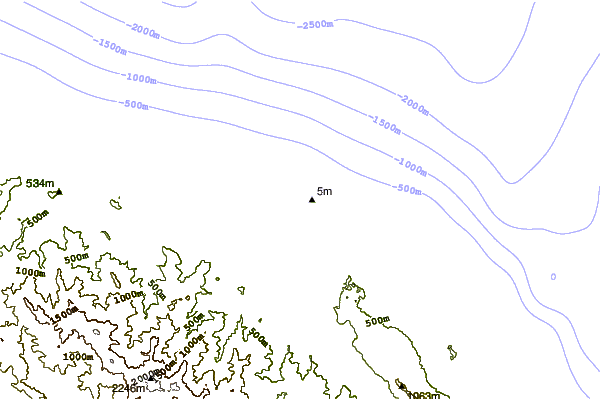
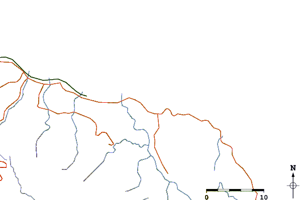
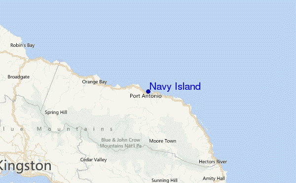
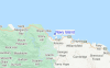
Use este mapa de relevo para navegar até Jamaica surf quebras e estações que estão na área de maré Navy Island
Outros Spots de Surf mais próximos de Navy Island:
(Clique no nome do local para maiores detalhes)- Closest spot6 mi
- Second closest spot9 mi
- Third closest spot11 mi
- Fourth closest spot12 mi
- Fifth closest spot23 mi
Bóias ondográficas mais próxima de Navy Island:
- Closest bóia ondográfica346 mi
- Second closest bóia ondográfica533 mi
- Third closest bóia ondográfica574 mi
- Fourth closest bóia ondográfica602 mi
- Fifth closest bóia ondográfica653 mi
Estações de maré mais próximo de Navy Island:
- Closest estação de maréPort Antonio5 mi
- Second closest estação de maréMorant Bay21 mi
- Third closest estação de maréPort Morant22 mi
- Fourth closest estação de maréYallahs24 mi
- Fifth closest estação de maréNew Kingston25 mi
Airports
- The closest passenger airport to Navy Island is Ken Jones (Port Antonio) Airport (POT) in Jamaica, 9 km (6 miles) away (directly).
- The second nearest airport to Navy Island is Norman Manley International (Kingston) Airport (KIN), also in Jamaica, 45 km (28 miles) away.
- Third is Tinson Pen (Kingston) Airport (KTP) in Jamaica, 45 km (28 miles) away.
- Boscobel (Ocho Rios) Airport (OCJ) in Jamaica is 59 km (37 miles) away.
- Sangster International (Montego Bay) Airport (MBJ), also in Jamaica is the fifth nearest airport to Navy Island and is 158 km (98 miles) away.
- /breaks/Navy-Island/forecasts/latest
 Nearest