
Previsão:

Previsão de curto prazoChuva intensa (total 38mm), mais intensa durante Sexta à noite. Warm (máx. 29°C na Qui de manhã, mín 27°C na Sexta de noite). principalmente ventos frescos. | ||||||||||||||||||||||||
Quar 15 | Quinta-feira 16 | Sexta-feira 17 | Sábado 18 | |||||||||||||||||||||
7 PM | 10 PM | 1 AM | 4 AM | 7 AM | 10 AM | 1 PM | 4 PM | 7 PM | 10 PM | 1 AM | 4 AM | 7 AM | 10 AM | 1 PM | 4 PM | 7 PM | 10 PM | 1 AM | 4 AM | 7 AM | 10 AM | 1 PM | 4 PM | |
Mapa da altura do Swell | 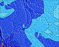 | 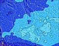 | 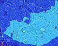 | 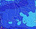 | 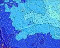 | 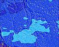 | 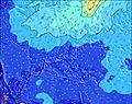 | 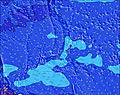 |  | |||||||||||||||
Swell Altura (m) Direção Período (s) | WSW 8 | WSW 8 | WSW 8 | WSW 8 | WSW 8 | WSW 8 | WSW 8 | WSW 7 | WSW 7 | WSW 7 | WSW 7 | WSW 7 | WSW 7 | WSW 7 | WSW 7 | WSW 7 | WSW 7 | WSW 7 | WSW 7 | WSW 7 | WSW 7 | WSW 7 | WSW 7 | WSW 7 |
Onda Gráfico | ||||||||||||||||||||||||
199 | 209 | 196 | 196 | 196 | 204 | 226 | 234 | 249 | 249 | 273 | 231 | 231 | 208 | 203 | 158 | 149 | 158 | 158 | 158 | 128 | 102 | 108 | 102 | |
Vento (km/h) | ||||||||||||||||||||||||
Estado do Vento maral cruzado-maral Cruzado cruzado-terral terral cristalino | cross | cross | cross | cross | cross | cross | cross | cross | cross | cross | cross | cross-on | cross | cross | cross-on | cross-on | cross-on | cross-on | cross-on | cross | cross | cross | cross | cross |
Maré Alta | 9:46PM0.79m | 7:44AM0.77m | 10:23PM0.78m | 8:42AM0.73m | 10:59PM0.77m | 9:42AM0.68m | ||||||||||||||||||
Maré Baixa | 2:49AM0.49m | 3:05PM-0.21m | 3:40AM0.44m | 3:49PM-0.13m | 4:33AM0.38m | |||||||||||||||||||
— | — | — | 6:01 | — | — | — | — | — | — | — | 6:01 | — | — | — | — | — | — | — | 6:01 | — | — | — | — | |
— | — | — | — | — | — | — | 6:52 | — | — | — | — | — | — | — | 6:52 | — | — | — | — | — | — | — | 6:52 | |
mm | — | 1 | 1 | — | — | 1 | 2 | — | — | 2 | 1 | 3 | 2 | 3 | 1 | 2 | 3 | 3 | 2 | 6 | 4 | — | — | — |
Temp. °C | 28 | 28 | 28 | 28 | 28 | 28 | 29 | 29 | 28 | 28 | 28 | 28 | 28 | 28 | 29 | 28 | 28 | 28 | 28 | 27 | 27 | 27 | 28 | 28 |
Ressent. °C | 30 | 30 | 30 | 30 | 29 | 29 | 30 | 30 | 29 | 29 | 29 | 29 | 30 | 29 | 30 | 29 | 29 | 30 | 30 | 30 | 30 | 29 | 30 | 29 |
Swell 1 Altura (m) Direção Período (s) | SE 9 | SSE 8 | SE 8 | SSE 8 | SSE 8 | SSE 8 | SSE 8 | SSE 8 | SSE 8 | ENE 9 | ENE 9 | ENE 9 | ENE 9 | ENE 9 | ENE 9 | WSW 7 | ENE 9 | ENE 9 | WSW 7 | E 9 | WSW 7 | WSW 7 | ENE 9 | ENE 9 |
36 | 28 | 35 | 27 | 27 | 27 | 27 | 28 | 27 | 28 | 28 | 29 | 28 | 28 | 28 | 158 | 29 | 29 | 158 | 44 | 128 | 102 | 28 | 28 | |
Swell 2 Altura (m) Direção Período (s) | E 10 | E 10 | E 10 | E 10 | E 10 | E 9 | E 9 | ENE 9 | ENE 9 | SSE 8 | SE 8 | SE 8 | SE 8 | SE 8 | SE 8 | ENE 9 | SE 8 | SE 8 | E 9 | SSE 7 | E 9 | ENE 9 | SSE 7 | S 5 |
29 | 29 | 29 | 29 | 29 | 28 | 27 | 29 | 28 | 26 | 17 | 17 | 17 | 17 | 16 | 29 | 15 | 9 | 44 | 5 | 43 | 28 | 10 | 2 | |
Swell 3 Altura (m) Direção Período (s) | WNW 9 | WNW 9 | NNE 8 | NNE 8 | NNE 8 | S 8 | S 8 | S 8 | S 8 | S 8 | S 8 | S 8 | S 8 | S 8 | S 8 | SE 8 | S 8 | S 7 | SE 8 | S 7 | SSE 7 | SSE 7 | NNW 7 | SSE 7 |
16 | 8 | 6 | 6 | 7 | 5 | 5 | 5 | 5 | 5 | 10 | 10 | 10 | 10 | 10 | 16 | 5 | 4 | 9 | 4 | 5 | 10 | 4 | 5 | |
Ondas de vento Altura (m) Direção Período (s) | WSW 8 | WSW 8 | WSW 8 | WSW 8 | WSW 8 | WSW 8 | WSW 8 | WSW 7 | WSW 7 | WSW 7 | WSW 7 | WSW 7 | WSW 7 | WSW 7 | WSW 7 | — | WSW 7 | WSW 7 | — | WSW 7 | — | — | WSW 7 | WSW 7 |
199 | 209 | 196 | 196 | 196 | 204 | 226 | 234 | 249 | 249 | 273 | 231 | 231 | 208 | 203 | — | 149 | 158 | — | 158 | — | — | 108 | 102 | |
Terral ou glassy mais perto | ||||||||||||||||||||||||
Distância (km) | 244 | 244 | 244 | 1845 | 244 | 244 | 2063 | 2189 | 244 | 244 | 244 | 14 | 244 | 244 | 244 | 14 | 14 | 14 | 14 | 244 | 14 | 244 | 244 | 244 |
Melhor previsões de ondas em Guam | ||||||||||||||||||||||||
Melhor previsões de ondas em Guam | ||||||||||||||||||||||||
Buscador de Ondas Global | ||||||||||||||||||||||||
- Map Icons:
 Break
Break Live Wave Height (m)
 Live Wind Speed (km/h)
 Surf Rating (10 Max)
 Ocean Swells (m)
- Wind Speed (km/h)
widget de graça do Surf-Forecast.com para o seu site
O relatório de surf / widget do tempo abaixo está disponível para incorporar em sites de terceiros gratuitamente e fornece um resumo das nossas Mutungs surf tempo. Simplesmente pegar o trecho de código html que fornecemos e colá-lo em seu próprio site. Você pode escolher seu idioma preferido e unidades métrico/imperial para o surf tempo de alimentação para atender aos usuários do seu site.... Clique aqui para adquirir o código.
 Nearest