
Previsão:

Previsão de curto prazochuviscos (total 4mm), principalmente caindo na Sexta de noite. Warm (máx. 24°C na Sexta de manhã, mín 21°C no Domingo à noite). o vento será geralmente fraco. | ||||||||||||||||||||||
Sexta-feira 17 | Sábado 18 | Domingo 19 | ||||||||||||||||||||
7 AM | 10 AM | 1 PM | 4 PM | 7 PM | 10 PM | 1 AM | 4 AM | 7 AM | 10 AM | 1 PM | 4 PM | 7 PM | 10 PM | 1 AM | 4 AM | 7 AM | 10 AM | 1 PM | 4 PM | 7 PM | 10 PM | |
Mapa da altura do Swell |  | 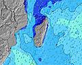 | 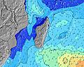 | 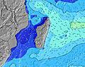 | 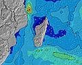 | 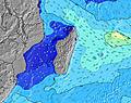 | 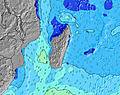 | 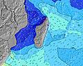 | ||||||||||||||
Swell Altura (m) Direção Período (s) | S 12 | S 17 | S 17 | S 16 | S 16 | S 16 | S 15 | S 14 | S 14 | S 13 | S 13 | S 13 | S 12 | SSW 11 | SSW 11 | SW 16 | SW 16 | SW 16 | SW 16 | SW 15 | SW 15 | SW 15 |
Onda Gráfico | ||||||||||||||||||||||
193 | 284 | 448 | 853 | 952 | 942 | 836 | 694 | 674 | 521 | 408 | 329 | 289 | 209 | 158 | 171 | 208 | 254 | 251 | 322 | 305 | 301 | |
Vento (km/h) | ||||||||||||||||||||||
Estado do Vento maral cruzado-maral Cruzado cruzado-terral terral cristalino | cross | cross | cross | cross-on | cross-on | on | cross | cross | cross | cross | cross-on | cross-on | cross-on | cross | cross | cross-on | glassy | cross | cross-on | cross-on | cross | cross-off |
Maré Alta | 3:11PM0.63m | 2:52AM0.68m | 3:42PM0.61m | 3:25AM0.62m | 4:11PM0.58m | |||||||||||||||||
Maré Baixa | 8:51AM0.03m | 8:55PM0.21m | 9:24AM0.10m | 9:33PM0.24m | 9:54AM0.17m | |||||||||||||||||
6:46 | — | — | — | — | — | — | 6:46 | — | — | — | — | — | — | — | 6:46 | — | — | — | — | — | — | |
— | — | — | 5:46 | — | — | — | — | — | — | — | 5:46 | — | — | — | — | — | — | — | 5:47 | — | — | |
mm | 1 | 1 | — | — | 1 | 2 | — | — | — | — | — | — | — | — | — | — | — | — | — | — | — | — |
Temp. °C | 23 | 24 | 24 | 24 | 23 | 23 | 23 | 23 | 22 | 23 | 23 | 23 | 23 | 22 | 22 | 22 | 22 | 22 | 23 | 23 | 22 | 22 |
Ressent. °C | 23 | 24 | 24 | 24 | 24 | 25 | 24 | 23 | 22 | 24 | 23 | 24 | 24 | 23 | 23 | 24 | 24 | 23 | 24 | 23 | 23 | 23 |
Swell 1 Altura (m) Direção Período (s) | S 12 | S 17 | S 17 | S 16 | S 16 | S 16 | S 15 | S 14 | S 14 | S 13 | S 13 | S 13 | S 12 | SSW 11 | SSW 11 | SSW 11 | SSW 10 | SW 16 | SW 16 | SW 15 | SW 15 | SW 15 |
193 | 284 | 448 | 853 | 952 | 942 | 836 | 694 | 674 | 521 | 408 | 329 | 289 | 209 | 158 | 150 | 108 | 254 | 251 | 322 | 305 | 301 | |
Swell 2 Altura (m) Direção Período (s) | SE 8 | S 12 | S 12 | ESE 8 | ESE 8 | ESE 8 | ESE 8 | ESE 8 | SW 5 | SW 5 | ESE 8 | ESE 8 | SW 5 | SW 5 | SW 18 | SW 16 | SW 16 | SSW 10 | S 10 | SSW 9 | SSW 9 | SSW 15 |
55 | 134 | 134 | 40 | 40 | 40 | 28 | 27 | 19 | 21 | 23 | 23 | 13 | 9 | 109 | 171 | 208 | 77 | 70 | 29 | 29 | 130 | |
Swell 3 Altura (m) Direção Período (s) | S 18 | ESE 8 | ESE 8 | SSW 11 | SSW 11 | WNW 4 | NW 4 | S 7 | ESE 8 | ESE 8 | SSE 7 | SW 18 | ESE 8 | SW 18 | SW 5 | SE 8 | ESE 8 | ESE 8 | ESE 8 | SSE 12 | SSW 5 | SSW 9 |
159 | 46 | 46 | 12 | 12 | 6 | 4 | 8 | 23 | 23 | 9 | 53 | 24 | 111 | 9 | 18 | 13 | 13 | 13 | 46 | 5 | 17 | |
Ondas de vento Altura (m) Direção Período (s) | NNW 3 | NW 4 | NW 4 | NW 4 | WNW 4 | — | SSW 4 | SW 4 | — | — | SW 5 | SW 5 | — | — | — | — | — | — | — | — | — | — |
5 | 10 | 14 | 12 | 10 | — | 5 | 9 | — | — | 18 | 18 | — | — | — | — | — | — | — | — | — | — | |
Terral ou glassy mais perto | ||||||||||||||||||||||
Distância (km) | 11 | 15 | 41 | 18 | 15 | 13 | 0 | 0 | 0 | 0 | 7 | 7 | 0 | 0 | 0 | 0 | 0 | 0 | 0 | 0 | 0 | 0 |
Melhor previsões de ondas em Mauritius | ||||||||||||||||||||||
Melhor previsões de ondas em Mauritius | ||||||||||||||||||||||
Buscador de Ondas Global | ||||||||||||||||||||||
- Map Icons:
 Break
Break Live Wave Height (m)
 Live Wind Speed (km/h)
 Surf Rating (10 Max)
 Ocean Swells (m)
- Wind Speed (km/h)
widget de graça do Surf-Forecast.com para o seu site
O relatório de surf / widget do tempo abaixo está disponível para incorporar em sites de terceiros gratuitamente e fornece um resumo das nossas Morne Rights surf tempo. Simplesmente pegar o trecho de código html que fornecemos e colá-lo em seu próprio site. Você pode escolher seu idioma preferido e unidades métrico/imperial para o surf tempo de alimentação para atender aos usuários do seu site.... Clique aqui para adquirir o código.
 Nearest