

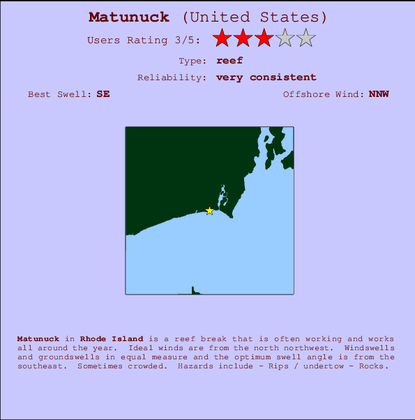
Matunuck Surf Guide
Matunuck in Rhode Island is a sheltered reef break that is often working and works all around the year. The best wind direction is from the north northwest. Tends to receive a mix of groundswells and windswells and the best swell direction is from the southeast. A fairly popluar wave that can sometimes get crowded Beware of - Rips / undertow - Rocks.
Matunuck Spot Info
| Type: | Rating: | Reliability: | Todays Sea Temp*: |
|---|---|---|---|
| very consistent | 20.7°C*ocean temperature recorded from satellite |
Surfing Matunuck:
The best conditions reported for surf at Matunuck occur when a Southeast swell combines with an offshore wind direction from the North-northwest.

Previsão da Energia de Ondas (Força): 12hrs


Matunuck Surf:
Wednesday, 29 July 2026, 07:45 Local time| Quarta-feira 29 | ||||
| 5AM | 8AM | 11AM | 2PM | |
| Wave (m) | ||||
| Período (s) | 6 | 6 | 6 | 6 |
| Vento (km/h) | ||||
| Estado do Vento | cross- on |
cross- on |
cross- on |
cross- on |
- /breaks/Matunuck/forecasts/latest
Matunuck Surf Guide
Matunuck in Rhode Island is a sheltered reef break that is often working and works all around the year. The best wind direction is from the north northwest. Tends to receive a mix of groundswells and windswells and the best swell direction is from the southeast. A fairly popluar wave that can sometimes get crowded Beware of - Rips / undertow - Rocks.
Matunuck Spot Info
Type: Rating: Reliability: Todays Sea Temp*:  Reef
Reef 3
3very consistent 20.7°C*ocean temperature recorded from satelliteSurfing Matunuck:
The best conditions reported for surf at Matunuck occur when a Southeast swell combines with an offshore wind direction from the North-northwest.
Previsão da Energia de Ondas (Força): 12hrs
Use a aba navegação acima para ver temperatura do mar em Matunuck, fotografias de Matunuck, previsões detalhadas do swell em Matunuck, previsões do vento e do tempo, webcams em Matunuck , vento atual em Rhode Island com base em dados ao vivo fornecidos por estações de meteorologia e previsões da maré em Matunuck. O link para os mapas do swell em United States abrirá uma imagem ampliada monstrando United States e os mares próximos. Estes mapas do swell podem ser animados para mostrar diferentes componentes do swell, energia das ondas, período das ondas, altura das ondas, assim como previsões do vento e do tempo, observações em tempo real do estado do tempo e do mar graças às bóias de United States, navios passantes e estações de meteorologia presentes na costa. Cada uma das páginas de previsão para este surf break apresenta as ferramentas do buscador global e regional para localizar as melores condições de surf na área ao redor de Matunuck.
Matunuck Surf:
Wednesday, 29 July 2026, 07:45 Local timeQuarta-feira 29 5AM 8AM 11AM 2PM Wave (m) Período (s) 6 6 6 6 Vento (km/h) Estado do Vento cross-
oncross-
oncross-
oncross-
on- /breaks/Matunuck/forecasts/latest
- /breaks/Matunuck/forecasts/latest/six_day
Matunuck Surf Guide
Matunuck in Rhode Island is a sheltered reef break that is often working and works all around the year. The best wind direction is from the north northwest. Tends to receive a mix of groundswells and windswells and the best swell direction is from the southeast. A fairly popluar wave that can sometimes get crowded Beware of - Rips / undertow - Rocks.
Matunuck Spot Info
Type: Rating: Reliability: Todays Sea Temp*: Reef3very consistent 20.7°C*ocean temperature recorded from satelliteSurfing Matunuck:
The best conditions reported for surf at Matunuck occur when a Southeast swell combines with an offshore wind direction from the North-northwest.
Previsão da Energia de Ondas (Força): 12hrs
Use a aba navegação acima para ver temperatura do mar em Matunuck, fotografias de Matunuck, previsões detalhadas do swell em Matunuck, previsões do vento e do tempo, webcams em Matunuck , vento atual em Rhode Island com base em dados ao vivo fornecidos por estações de meteorologia e previsões da maré em Matunuck. O link para os mapas do swell em United States abrirá uma imagem ampliada monstrando United States e os mares próximos. Estes mapas do swell podem ser animados para mostrar diferentes componentes do swell, energia das ondas, período das ondas, altura das ondas, assim como previsões do vento e do tempo, observações em tempo real do estado do tempo e do mar graças às bóias de United States, navios passantes e estações de meteorologia presentes na costa. Cada uma das páginas de previsão para este surf break apresenta as ferramentas do buscador global e regional para localizar as melores condições de surf na área ao redor de Matunuck.
Matunuck Surf:
Wednesday, 29 July 2026, 07:45 Local timeQuarta-feira 29 5AM 8AM 11AM 2PM Wave (m) Período (s) 6 6 6 6 Vento (km/h) Estado do Vento cross-
oncross-
oncross-
oncross-
on- /breaks/Matunuck/forecasts/latest
Matunuck Surf Guide
Matunuck in Rhode Island is a sheltered reef break that is often working and works all around the year. The best wind direction is from the north northwest. Tends to receive a mix of groundswells and windswells and the best swell direction is from the southeast. A fairly popluar wave that can sometimes get crowded Beware of - Rips / undertow - Rocks.
Matunuck Spot Info
Type: Rating: Reliability: Todays Sea Temp*: Reef3very consistent 20.7°C*ocean temperature recorded from satelliteSurfing Matunuck:
The best conditions reported for surf at Matunuck occur when a Southeast swell combines with an offshore wind direction from the North-northwest.
Previsão da Energia de Ondas (Força): 12hrs
Use a aba navegação acima para ver temperatura do mar em Matunuck, fotografias de Matunuck, previsões detalhadas do swell em Matunuck, previsões do vento e do tempo, webcams em Matunuck , vento atual em Rhode Island com base em dados ao vivo fornecidos por estações de meteorologia e previsões da maré em Matunuck. O link para os mapas do swell em United States abrirá uma imagem ampliada monstrando United States e os mares próximos. Estes mapas do swell podem ser animados para mostrar diferentes componentes do swell, energia das ondas, período das ondas, altura das ondas, assim como previsões do vento e do tempo, observações em tempo real do estado do tempo e do mar graças às bóias de United States, navios passantes e estações de meteorologia presentes na costa. Cada uma das páginas de previsão para este surf break apresenta as ferramentas do buscador global e regional para localizar as melores condições de surf na área ao redor de Matunuck.
Matunuck Surf:
Wednesday, 29 July 2026, 07:45 Local timeQuarta-feira 29 5AM 8AM 11AM 2PM Wave (m) Período (s) 6 6 6 6 Vento (km/h) Estado do Vento cross-
oncross-
oncross-
oncross-
onTide Times:
Para Moonstone Beach, Rhode Island %{dist} %{km} de %{location}
A PRÓXIMA É ÀS (hora local) faltam maré alta maré baixa Matunuck Tide Times and Tide Chart
Live Weather:
At BUOY-NWPR1, 22 km from Matunuck.
moderate winds from the ESE
(km/h)Air temperature
21.8°CBuoy Data:
At Block Island, RI, 35 miles from Matunuck.
2AM 3AM 4AM 5AM Idade dos dados 4 hr 3 hr 2 hr 1 hr Altura de onda (m) 

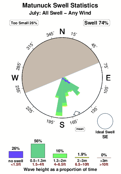
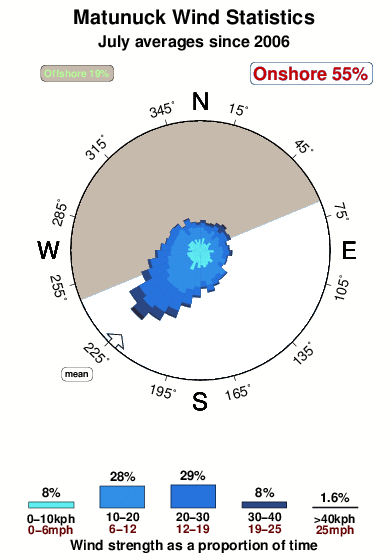
Período Dominante (s) 6 5 5 6 Overall Matunuck Surf Consistency and Wind Distribution in Julho
fotos da galeria
Contornos: Estradas & Rios: Escolha um spot de surf da lista 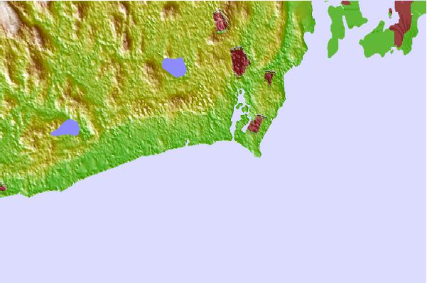
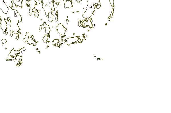
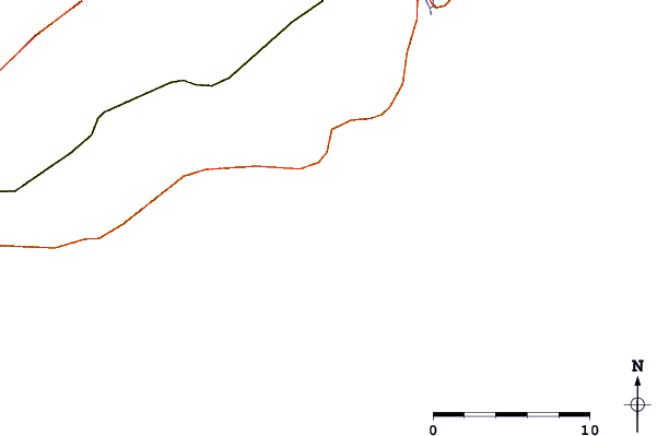
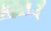
Use este mapa de relevo para navegar até Rhode Island surf quebras e estações que estão na área de maré Matunuck
Outros Spots de Surf mais próximos de Matunuck:
(Clique no nome do local para maiores detalhes)- Closest spot0 mi
- Second closest spot1 mi
- Third closest spot1 mi
- Fourth closest spot2 mi
- Fifth closest spot2 mi
Bóias ondográficas mais próxima de Matunuck:
- Closest bóia ondográfica35 mi
- Second closest bóia ondográfica54 mi
- Third closest bóia ondográfica60 mi
- Fourth closest bóia ondográfica70 mi
- Fifth closest bóia ondográfica70 mi
Estações de maré mais próximo de Matunuck:
- Closest estação de maréMoonstone Beach1 mi
- Second closest estação de maréPoint Judith Harbor of Refuge2 mi
- Third closest estação de maréNarragansett Pier, Narragansett Bay6 mi
- Fourth closest estação de maréCharlestown6 mi
- Fifth closest estação de maréWatson Pier, Boston Neck, Narragansett Bay8 mi
Airports
- The closest passenger airport to Matunuck is Theodore Francis Green State (Providence) Airport (PVD) in USA, 40 km (25 miles) away (directly).
- The second nearest airport to Matunuck is North Central State (Smithfield) Airport (SFZ), also in USA, 61 km (38 miles) away.
- Third is Otis Angb (Falmouth) Airport (FMH) in USA, 90 km (56 miles) away.
- Hartford Brainard Airport (HFD) in USA is 101 km (63 miles) away.
- The Francis S Gabreski (West Hampton Beach) Airport (FOK), also in USA is the fifth nearest airport to Matunuck and is 109 km (68 miles) away.
- /breaks/Matunuck/forecasts/latest


 Nearest