
Previsão:

Previsão de curto prazoprincipalmente seco. Warm (máx. 23°C na Segunda à tarde, mín 20°C no Domingo à noite). o vento será geralmente fraco. | |||||||||||||||||||||||
Domingo 26 | Segunda-feira 27 | Terça-feira 28 | |||||||||||||||||||||
4 AM | 7 AM | 10 AM | 1 PM | 4 PM | 7 PM | 10 PM | 1 AM | 4 AM | 7 AM | 10 AM | 1 PM | 4 PM | 7 PM | 10 PM | 1 AM | 4 AM | 7 AM | 10 AM | 1 PM | 4 PM | 7 PM | 10 PM | |
Mapa da altura do Swell |  |  | 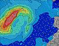 |  | 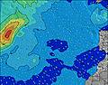 |  |  | 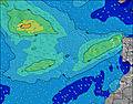 |  | ||||||||||||||
Swell Altura (m) Direção Período (s) | NNE 8 | NNE 8 | NNE 8 | NNE 8 | NNE 8 | NNE 8 | NNE 8 | NNE 8 | NNE 8 | NNE 8 | NNE 8 | NNE 8 | NNE 8 | NNE 8 | NNE 8 | NNE 8 | NNE 8 | NNE 8 | NNE 8 | NNE 8 | NNE 8 | NNE 7 | NNE 7 |
Onda Gráfico | |||||||||||||||||||||||
672 | 672 | 696 | 643 | 659 | 597 | 560 | 492 | 480 | 388 | 378 | 318 | 283 | 283 | 283 | 283 | 244 | 204 | 204 | 204 | 204 | 199 | 199 | |
Vento (km/h) | |||||||||||||||||||||||
Estado do Vento maral cruzado-maral Cruzado cruzado-terral terral cristalino | on | on | cross-on | cross-on | on | on | on | on | on | on | on | on | on | on | on | on | on | on | on | on | on | on | on |
Maré Alta | 12:33PM1.73m | 00:58AM1.65m | 1:14PM1.85m | 1:36AM1.75m | 1:50PM1.96m | ||||||||||||||||||
Maré Baixa | 6:15AM0.61m | 6:51PM0.51m | 6:57AM0.51m | 7:29PM0.41m | 7:33AM0.41m | 8:04PM0.32m | |||||||||||||||||
— | 7:20 | — | — | — | — | — | — | — | 7:20 | — | — | — | — | — | — | — | 7:22 | — | — | — | — | — | |
— | — | — | — | — | 8:55 | — | — | — | — | — | — | — | 8:54 | — | — | — | — | — | — | — | 8:54 | — | |
mm | — | — | — | — | — | — | — | — | — | — | — | — | — | — | — | — | — | — | — | — | — | — | — |
Temp. °C | 20 | 20 | 21 | 22 | 22 | 22 | 21 | 21 | 21 | 20 | 21 | 22 | 23 | 22 | 21 | 20 | 20 | 20 | 21 | 22 | 23 | 22 | 20 |
Ressent. °C | 17 | 18 | 19 | 20 | 20 | 21 | 20 | 20 | 20 | 18 | 20 | 21 | 22 | 21 | 21 | 19 | 19 | 19 | 20 | 21 | 22 | 21 | 19 |
Swell 1 Altura (m) Direção Período (s) | W 10 | NW 10 | NW 10 | NW 10 | NW 10 | NW 9 | NW 9 | NW 9 | NW 9 | NW 9 | NW 9 | NW 9 | NW 9 | NW 9 | NW 9 | NW 8 | NW 8 | NW 8 | N 13 | N 13 | N 12 | N 12 | N 11 |
2 | 4 | 4 | 4 | 4 | 3 | 3 | 3 | 3 | 3 | 3 | 3 | 3 | 3 | 3 | 3 | 3 | 3 | 3 | 3 | 12 | 11 | 10 | |
Swell 2 Altura (m) Direção Período (s) | S 14 | S 14 | S 14 | S 11 | S 11 | S 11 | S 12 | S 12 | S 13 | S 13 | S 13 | S 13 | S 13 | S 13 | S 13 | N 15 | N 14 | N 13 | NW 8 | NW 8 | NW 12 | NW 12 | NW 12 |
4 | 4 | 4 | 2 | 2 | 3 | 3 | 3 | 3 | 3 | 3 | 3 | 3 | 3 | 3 | 4 | 4 | 4 | 3 | 3 | 6 | 6 | 6 | |
Swell 3 Altura (m) Direção Período (s) | — | — | — | S 14 | — | — | — | — | — | W 9 | — | — | — | — | — | N 15 | — | W 13 | W 13 | W 12 | NW 8 | W 8 | W 8 |
— | — | — | 4 | — | — | — | — | — | 2 | — | — | — | — | — | 4 | — | 3 | 3 | 3 | 3 | 1 | 1 | |
Ondas de vento Altura (m) Direção Período (s) | NNE 8 | NNE 8 | NNE 8 | NNE 8 | NNE 8 | NNE 8 | NNE 8 | NNE 8 | NNE 8 | NNE 8 | NNE 8 | NNE 8 | NNE 8 | NNE 8 | NNE 8 | NNE 8 | NNE 8 | NNE 8 | NNE 8 | NNE 8 | NNE 8 | NNE 7 | NNE 7 |
672 | 672 | 696 | 643 | 659 | 597 | 560 | 492 | 480 | 388 | 378 | 318 | 283 | 283 | 283 | 283 | 244 | 204 | 204 | 204 | 204 | 199 | 199 | |
Terral ou glassy mais perto | |||||||||||||||||||||||
Distância (km) | 115 | 115 | 115 | 115 | 38 | 115 | 115 | 115 | 70 | 70 | 38 | 38 | 38 | 38 | 38 | 38 | 38 | 38 | 38 | 38 | 70 | 124 | 38 |
Melhor previsões de ondas em Gran Canaria | |||||||||||||||||||||||
Melhor previsões de ondas em Spain (Africa) | |||||||||||||||||||||||
Buscador de Ondas Global | |||||||||||||||||||||||
- Map Icons:
 Break
Break Live Wave Height (m)
 Live Wind Speed (km/h)
 Surf Rating (10 Max)
 Ocean Swells (m)
- Wind Speed (km/h)
widget de graça do Surf-Forecast.com para o seu site
O relatório de surf / widget do tempo abaixo está disponível para incorporar em sites de terceiros gratuitamente e fornece um resumo das nossas Las Piscinas surf tempo. Simplesmente pegar o trecho de código html que fornecemos e colá-lo em seu próprio site. Você pode escolher seu idioma preferido e unidades métrico/imperial para o surf tempo de alimentação para atender aos usuários do seu site.... Clique aqui para adquirir o código.
 Nearest