
Previsão:

Previsão de curto prazoChuva intensa (total 115mm), mais intensa durante Quinta à noite. Very mild (máx. 16°C na Quarta à tarde, mín 12°C na Qui à noite). Ventos aumentam (vento fraco de Nor-Nordeste na Quarta à noite, vento forte de Nor-Nordeste na Quinta à tarde). | ||||||||||||||||||||||||
Quar 15 | Quinta-feira 16 | Sexta-feira 17 | Sáb 18 | |||||||||||||||||||||
11 AM | 2 PM | 5 PM | 8 PM | 11 PM | 2 AM | 5 AM | 8 AM | 11 AM | 2 PM | 5 PM | 8 PM | 11 PM | 2 AM | 5 AM | 8 AM | 11 AM | 2 PM | 5 PM | 8 PM | 11 PM | 2 AM | 5 AM | 8 AM | |
Mapa da altura do Swell |  |  | 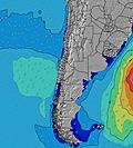 | 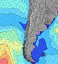 |  |  | 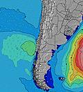 | 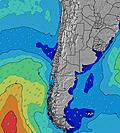 |  | |||||||||||||||
Swell Altura (m) Direção Período (s) | WNW 11 | WNW 10 | WNW 10 | W 10 | WNW 8 | WNW 8 | NW 7 | NNW 7 | NNW 8 | NNW 8 | WNW 11 | NW 11 | NNW 10 | NNW 10 | NNW 10 | NNW 10 | NNW 10 | NNW 9 | NNW 9 | NNW 9 | NNW 9 | WNW 10 | N 8 | NNW 9 |
Onda Gráfico | ||||||||||||||||||||||||
423 | 351 | 383 | 377 | 188 | 206 | 246 | 428 | 791 | 1728 | 1439 | 3104 | 1184 | 1883 | 1402 | 1611 | 2194 | 2003 | 971 | 772 | 518 | 403 | 548 | 954 | |
Vento (km/h) | ||||||||||||||||||||||||
Estado do Vento maral cruzado-maral Cruzado cruzado-terral terral cristalino | cross-on | on | on | cross-on | cross-on | cross-on | cross-on | on | cross-on | cross-on | cross-on | cross-on | cross-on | on | cross-on | cross-on | on | on | on | on | cross-on | cross-on | cross-on | cross-on |
Maré Alta | 10:54AM1.66m | 11:32PM0.99m | 11:41AM1.63m | 00:19AM1.02m | 12:27PM1.55m | 1:06AM1.05m | ||||||||||||||||||
Maré Baixa | 5:41PM-0.06m | 5:05AM0.07m | 6:25PM-0.05m | 5:55AM0.10m | 7:08PM-0.01m | 6:47AM0.16m | ||||||||||||||||||
— | — | — | — | — | — | 7:48 | — | — | — | — | — | — | — | 7:47 | — | — | — | — | — | — | — | 7:47 | — | |
— | — | 5:57 | — | — | — | — | — | — | — | 5:57 | — | — | — | — | — | — | — | 5:58 | — | — | — | — | 5:59 | |
mm | — | — | — | — | — | — | — | — | 2 | 6 | 7 | 6 | 8 | 15 | 7 | 10 | 12 | 3 | 3 | 6 | 6 | 5 | 5 | 11 |
Temp. °C | 15 | 16 | 15 | 14 | 14 | 14 | 15 | 15 | 14 | 14 | 13 | 13 | 13 | 12 | 12 | 13 | 14 | 14 | 14 | 13 | 13 | 13 | 12 | 12 |
Ressent. °C | 11 | 11 | 12 | 12 | 11 | 9 | 8 | 7 | 4 | 0 | 2 | 6 | 5 | 6 | 7 | 7 | 6 | 5 | 7 | 6 | 5 | 9 | 7 | 8 |
Swell 1 Altura (m) Direção Período (s) | WNW 11 | WNW 10 | WNW 10 | W 10 | WNW 8 | WNW 8 | NW 7 | SW 11 | SW 12 | SW 12 | WNW 11 | NW 11 | NNW 10 | WNW 11 | WNW 10 | WNW 10 | SW 14 | SW 14 | WNW 10 | WNW 10 | WNW 10 | WNW 10 | WNW 10 | SW 13 |
423 | 351 | 383 | 377 | 188 | 206 | 246 | 46 | 48 | 35 | 1439 | 3104 | 1184 | 561 | 551 | 349 | 234 | 218 | 443 | 434 | 434 | 370 | 402 | 130 | |
Swell 2 Altura (m) Direção Período (s) | SW 11 | SW 11 | SW 11 | SW 12 | SW 10 | SW 11 | SW 10 | WNW 13 | SW 18 | SW 17 | SW 17 | SW 16 | WNW 11 | SW 15 | SW 15 | SW 14 | W 16 | — | SW 13 | SW 13 | SW 13 | SW 13 | SW 13 | WSW 13 |
242 | 176 | 79 | 38 | 100 | 94 | 68 | 17 | 49 | 47 | 46 | 129 | 1155 | 191 | 136 | 203 | 5 | — | 208 | 208 | 205 | 134 | 132 | 59 | |
Swell 3 Altura (m) Direção Período (s) | NW 14 | NW 14 | NW 14 | NW 13 | W 10 | W 10 | WNW 13 | SW 18 | WNW 13 | — | SW 12 | — | SW 16 | — | SW 11 | W 16 | — | — | WSW 15 | WSW 15 | W 15 | W 14 | WSW 13 | — |
8 | 8 | 7 | 7 | 31 | 8 | 17 | 13 | 17 | — | 21 | — | 159 | — | 30 | 5 | — | — | 21 | 42 | 17 | 16 | 35 | — | |
Ondas de vento Altura (m) Direção Período (s) | — | — | — | — | — | NNE 4 | NE 4 | NNW 7 | NNW 8 | NNW 8 | N 8 | — | — | NNW 10 | NNW 10 | NNW 10 | NNW 10 | NNW 9 | NNW 9 | NNW 9 | NNW 9 | N 8 | N 8 | NNW 9 |
— | — | — | — | — | 13 | 8 | 428 | 791 | 1728 | 1251 | — | — | 1883 | 1402 | 1611 | 2194 | 2003 | 971 | 772 | 518 | 403 | 548 | 954 | |
Terral ou glassy mais perto | ||||||||||||||||||||||||
Distância (km) | 58 | 58 | 1 | 1 | 13 | 97 | 70 | 86 | 1299 | 189 | 425 | 425 | 58 | 97 | 86 | 97 | 289 | 189 | 351 | 289 | 97 | 58 | 58 | 495 |
Melhor previsões de ondas em Santiago | ||||||||||||||||||||||||
Melhor previsões de ondas em Chile | ||||||||||||||||||||||||
Buscador de Ondas Global | ||||||||||||||||||||||||
- Map Icons:
 Break
Break Live Wave Height (m)
 Live Wind Speed (km/h)
 Surf Rating (10 Max)
 Ocean Swells (m)
- Wind Speed (km/h)
widget de graça do Surf-Forecast.com para o seu site
O relatório de surf / widget do tempo abaixo está disponível para incorporar em sites de terceiros gratuitamente e fornece um resumo das nossas Isla Negra surf tempo. Simplesmente pegar o trecho de código html que fornecemos e colá-lo em seu próprio site. Você pode escolher seu idioma preferido e unidades métrico/imperial para o surf tempo de alimentação para atender aos usuários do seu site.... Clique aqui para adquirir o código.
 Nearest