
Previsão:

Previsão de curto prazoChuva intensa (total 30mm), mais intensa durante Terça de manhã. Warm (máx. 29°C na Segunda à tarde, mín 26°C na Seg à noite). principalmente ventos frescos. | |||||||||||||||||||||||
Segunda-feira 3 | Terça-feira 4 | Quarta-feira 5 | |||||||||||||||||||||
5 AM | 8 AM | 11 AM | 2 PM | 5 PM | 8 PM | 11 PM | 2 AM | 5 AM | 8 AM | 11 AM | 2 PM | 5 PM | 8 PM | 11 PM | 2 AM | 5 AM | 8 AM | 11 AM | 2 PM | 5 PM | 8 PM | 11 PM | |
Mapa da altura do Swell |  |  | 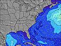 | 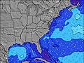 | 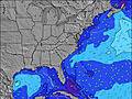 | 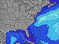 | 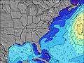 | 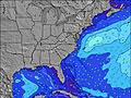 | 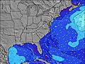 | ||||||||||||||
Swell Altura (m) Direção Período (s) | SSE 7 | SSE 7 | SSE 7 | SSE 7 | SSE 7 | S 6 | SSE 7 | SSE 7 | SSE 7 | SSE 7 | S 7 | SSE 6 | S 6 | S 6 | S 6 | SSE 6 | SE 6 | SSE 6 | SSE 6 | SE 6 | SE 6 | SE 6 | SE 6 |
Onda Gráfico | |||||||||||||||||||||||
147 | 139 | 145 | 57 | 77 | 104 | 181 | 121 | 157 | 64 | 145 | 53 | 32 | 24 | 21 | 47 | 59 | 75 | 77 | 30 | 62 | 37 | 29 | |
Vento (km/h) | |||||||||||||||||||||||
Estado do Vento maral cruzado-maral Cruzado cruzado-terral terral cristalino | cross-on | cross-on | cross-on | cross-on | cross-on | cross-on | cross-on | cross | cross | cross-on | cross-on | cross-on | cross-on | cross-on | cross-on | cross-on | cross-on | cross-on | cross-on | cross-on | cross-on | cross-on | cross-on |
Maré Alta | 12:35PM1.35m | 00:47AM1.29m | 1:26PM1.38m | 1:36AM1.23m | 2:24PM1.40m | ||||||||||||||||||
Maré Baixa | 7:23AM0.05m | 7:42PM0.16m | 8:05AM0.05m | 8:36PM0.20m | 8:54AM0.06m | 9:38PM0.24m | |||||||||||||||||
6:28 | — | — | — | — | — | — | — | 6:30 | — | — | — | — | — | — | — | 6:30 | — | — | — | — | — | — | |
— | — | — | — | — | 8:14 | — | — | — | — | — | — | — | 8:13 | — | — | — | — | — | — | — | 8:12 | — | |
mm | 4 | 2 | — | 2 | 2 | 3 | 1 | 1 | 2 | 4 | 2 | 1 | 1 | 1 | 1 | 1 | 1 | — | 1 | — | — | — | — |
Temp. °C | 27 | 27 | 28 | 29 | 29 | 26 | 26 | 26 | 26 | 26 | 27 | 28 | 28 | 28 | 27 | 27 | 27 | 27 | 28 | 27 | 28 | 28 | 28 |
Ressent. °C | 29 | 29 | 29 | 29 | 29 | 25 | 26 | 28 | 28 | 30 | 31 | 30 | 29 | 29 | 29 | 29 | 29 | 28 | 31 | 30 | 31 | 31 | 31 |
Swell 1 Altura (m) Direção Período (s) | SSE 7 | SSE 7 | SSE 7 | — | — | — | — | — | SSE 7 | SSE 7 | SSE 7 | SE 7 | SE 7 | SE 6 | SE 6 | — | SE 6 | SE 6 | SE 6 | — | SE 6 | — | — |
77 | 61 | 59 | — | — | — | — | — | 64 | 51 | 62 | 23 | 11 | 11 | 19 | — | 59 | 37 | 37 | — | 62 | — | — | |
Swell 2 Altura (m) Direção Período (s) | — | — | — | — | — | — | — | — | — | — | — | — | — | — | — | — | — | — | — | — | — | — | — |
— | — | — | — | — | — | — | — | — | — | — | — | — | — | — | — | — | — | — | — | — | — | — | |
Swell 3 Altura (m) Direção Período (s) | — | — | — | — | — | — | — | — | — | — | — | — | — | — | — | — | — | — | — | — | — | — | — |
— | — | — | — | — | — | — | — | — | — | — | — | — | — | — | — | — | — | — | — | — | — | — | |
Ondas de vento Altura (m) Direção Período (s) | SSE 7 | SSE 7 | SSE 7 | SSE 7 | SSE 7 | S 6 | SSE 7 | SSE 7 | SSE 7 | S 6 | S 7 | SSE 6 | S 6 | S 6 | S 6 | SSE 6 | SSE 6 | SSE 6 | SSE 6 | SE 6 | SE 6 | SE 6 | SE 6 |
147 | 139 | 145 | 57 | 77 | 104 | 181 | 121 | 157 | 64 | 145 | 53 | 32 | 24 | 21 | 47 | 43 | 75 | 77 | 30 | 37 | 37 | 29 | |
Terral ou glassy mais perto | |||||||||||||||||||||||
Distância (km) | 799 | 170 | 460 | 349 | 432 | 417 | 450 | 6 | 6 | 6 | 129 | 114 | 450 | 499 | 465 | 428 | 114 | 428 | 450 | 390 | 411 | 450 | 465 |
Melhor previsões de ondas em South Carolina | |||||||||||||||||||||||
Melhor previsões de ondas em United States | |||||||||||||||||||||||
Buscador de Ondas Global | |||||||||||||||||||||||
- Map Icons:
 Break
Break Live Wave Height (m)
 Live Wind Speed (km/h)
 Surf Rating (10 Max)
 Ocean Swells (m)
- Wind Speed (km/h)
widget de graça do Surf-Forecast.com para o seu site
O relatório de surf / widget do tempo abaixo está disponível para incorporar em sites de terceiros gratuitamente e fornece um resumo das nossas Garden City Pier surf tempo. Simplesmente pegar o trecho de código html que fornecemos e colá-lo em seu próprio site. Você pode escolher seu idioma preferido e unidades métrico/imperial para o surf tempo de alimentação para atender aos usuários do seu site.... Clique aqui para adquirir o código.
 Nearest