
Previsão:

Previsão de curto prazoprincipalmente seco. Warm (máx. 20°C no Domingo de manhã, mín 16°C na Seg à noite). o vento será geralmente fraco. | ||||||||||||||||||||||||
Domingo 2 | Segunda-feira 3 | Terça-feira 4 | ||||||||||||||||||||||
2 AM | 5 AM | 8 AM | 11 AM | 2 PM | 5 PM | 8 PM | 11 PM | 2 AM | 5 AM | 8 AM | 11 AM | 2 PM | 5 PM | 8 PM | 11 PM | 2 AM | 5 AM | 8 AM | 11 AM | 2 PM | 5 PM | 8 PM | 11 PM | |
Mapa da altura do Swell |  | 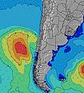 |  |  | 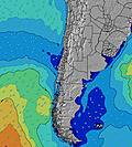 |  |  | 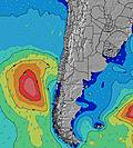 |  | |||||||||||||||
Swell Altura (m) Direção Período (s) | SW 10 | WSW 15 | WSW 14 | SW 9 | SW 10 | SW 10 | SW 10 | WSW 13 | SW 11 | SW 10 | SW 11 | SW 12 | SW 9 | SW 13 | SW 12 | SW 12 | SW 12 | SW 12 | SW 12 | SW 12 | SW 12 | SW 12 | SW 12 | SW 12 |
Onda Gráfico | ||||||||||||||||||||||||
255 | 142 | 140 | 159 | 250 | 245 | 204 | 154 | 422 | 241 | 369 | 319 | 149 | 653 | 481 | 773 | 827 | 827 | 813 | 736 | 736 | 736 | 736 | 736 | |
Vento (km/h) | ||||||||||||||||||||||||
Estado do Vento maral cruzado-maral Cruzado cruzado-terral terral cristalino | cross-on | cross-on | cross-on | on | on | cross-on | glassy | glassy | glassy | glassy | glassy | on | glassy | glassy | glassy | cross-off | cross-off | cross-off | cross-off | cross | cross | glassy | glassy | cross-off |
Maré Alta | 11:31PM0.97m | 11:31AM1.27m | 00:10AM1.00m | 12:04PM1.19m | 00:53AM1.03m | 12:42PM1.10m | ||||||||||||||||||
Maré Baixa | 5:05AM0.44m | 6:11PM0.35m | 5:48AM0.48m | 6:41PM0.36m | 6:39AM0.53m | 7:14PM0.38m | ||||||||||||||||||
— | 7:09 | — | — | — | — | — | — | — | 7:09 | — | — | — | — | — | — | — | 7:09 | — | — | — | — | — | — | |
— | — | — | — | — | 6:22 | — | — | — | — | — | — | — | 6:23 | — | — | — | — | — | — | — | 6:23 | — | — | |
mm | — | — | — | — | — | — | — | — | — | — | — | — | — | — | — | — | — | — | — | — | — | — | — | — |
Temp. °C | 17 | 18 | 17 | 20 | 19 | 18 | 18 | 17 | 17 | 17 | 17 | 19 | 19 | 18 | 16 | 17 | 16 | 16 | 17 | 19 | 19 | 18 | 16 | 17 |
Ressent. °C | 17 | 18 | 16 | 20 | 19 | 18 | 20 | 17 | 18 | 18 | 18 | 19 | 20 | 20 | 17 | 17 | 15 | 15 | 17 | 19 | 19 | 19 | 16 | 17 |
Swell 1 Altura (m) Direção Período (s) | SW 10 | WSW 10 | WSW 10 | SW 9 | SW 10 | SW 10 | SW 10 | SW 9 | SW 11 | SW 10 | SW 11 | SW 12 | SW 9 | SW 13 | SW 12 | SW 12 | SW 12 | SW 12 | SW 12 | SW 12 | SW 12 | SW 12 | SW 12 | SW 12 |
255 | 125 | 125 | 159 | 250 | 245 | 204 | 152 | 422 | 241 | 369 | 319 | 149 | 653 | 481 | 773 | 827 | 827 | 813 | 736 | 736 | 736 | 736 | 736 | |
Swell 2 Altura (m) Direção Período (s) | WSW 15 | WSW 15 | WSW 14 | WSW 14 | WSW 14 | WSW 14 | WSW 13 | SW 12 | WSW 13 | SSW 12 | WSW 13 | WSW 10 | SSW 12 | SSW 12 | SW 7 | W 12 | W 12 | W 11 | W 11 | W 12 | W 12 | SW 20 | SW 21 | SW 21 |
85 | 142 | 140 | 136 | 129 | 105 | 154 | 142 | 116 | 129 | 116 | 81 | 94 | 28 | 62 | 3 | 3 | 3 | 3 | 3 | 3 | 16 | 17 | 17 | |
Swell 3 Altura (m) Direção Período (s) | — | SW 10 | SW 10 | WSW 10 | SSW 14 | SW 13 | SSW 13 | WSW 13 | SSW 12 | WSW 13 | WSW 10 | SW 14 | SW 13 | W 12 | SSW 12 | — | W 12 | — | — | — | — | W 12 | W 11 | W 11 |
— | 61 | 57 | 39 | 20 | 83 | 111 | 154 | 101 | 114 | 10 | 65 | 113 | 3 | 28 | — | 3 | — | — | — | — | 3 | 3 | 2 | |
Ondas de vento Altura (m) Direção Período (s) | — | — | — | — | — | — | — | — | — | — | — | — | — | — | — | — | — | — | — | — | — | — | — | — |
— | — | — | — | — | — | — | — | — | — | — | — | — | — | — | — | — | — | — | — | — | — | — | — | |
Terral ou glassy mais perto | ||||||||||||||||||||||||
Distância (km) | 2 | 2 | 2 | 2 | 2 | 2 | 0 | 0 | 0 | 0 | 0 | 2 | 0 | 0 | 0 | 0 | 0 | 0 | 0 | 0 | 0 | 0 | 0 | 0 |
Melhor previsões de ondas em Tarapaca | ||||||||||||||||||||||||
Melhor previsões de ondas em Chile | ||||||||||||||||||||||||
Buscador de Ondas Global | ||||||||||||||||||||||||
- Map Icons:
 Break
Break Live Wave Height (m)
 Live Wind Speed (km/h)
 Surf Rating (10 Max)
 Ocean Swells (m)
- Wind Speed (km/h)
widget de graça do Surf-Forecast.com para o seu site
O relatório de surf / widget do tempo abaixo está disponível para incorporar em sites de terceiros gratuitamente e fornece um resumo das nossas El Faro surf tempo. Simplesmente pegar o trecho de código html que fornecemos e colá-lo em seu próprio site. Você pode escolher seu idioma preferido e unidades métrico/imperial para o surf tempo de alimentação para atender aos usuários do seu site.... Clique aqui para adquirir o código.
 Nearest