
Previsão:

Previsão de curto prazochuviscos (total 2mm), principalmente caindo no Domingo à noite. Warm (máx. 24°C no Domingo de manhã, mín 23°C no Domingo à noite). o vento será geralmente fraco. | ||||||||||||||||||||||||
Domingo 2 | Segunda-feira 3 | Terça-feira 4 | ||||||||||||||||||||||
1 AM | 4 AM | 7 AM | 10 AM | 1 PM | 4 PM | 7 PM | 10 PM | 1 AM | 4 AM | 7 AM | 10 AM | 1 PM | 4 PM | 7 PM | 10 PM | 1 AM | 4 AM | 7 AM | 10 AM | 1 PM | 4 PM | 7 PM | 10 PM | |
Mapa da altura do Swell |  |  |  |  |  | 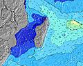 | 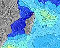 | 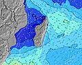 | 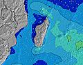 | |||||||||||||||
Swell Altura (m) Direção Período (s) | SSW 14 | SSW 14 | SSW 14 | SSW 14 | SSW 16 | SSW 16 | SW 15 | SW 15 | SW 14 | SW 14 | SW 14 | SW 14 | SW 14 | SW 13 | SW 13 | SW 13 | SW 13 | SW 13 | SW 13 | SW 13 | S 13 | S 13 | S 13 | S 12 |
Onda Gráfico | ||||||||||||||||||||||||
921 | 1028 | 752 | 626 | 1241 | 1098 | 918 | 773 | 667 | 648 | 639 | 557 | 526 | 392 | 340 | 246 | 246 | 205 | 168 | 161 | 165 | 215 | 155 | 143 | |
Vento (km/h) | ||||||||||||||||||||||||
Estado do Vento maral cruzado-maral Cruzado cruzado-terral terral cristalino | glassy | glassy | cross-off | cross-off | cross | on | cross | cross-off | off | cross | cross-off | glassy | glassy | glassy | cross-off | glassy | glassy | cross-off | cross-off | cross-off | cross-off | glassy | glassy | glassy |
Maré Alta | 2:27AM0.55m | 3:09PM0.53m | 3:00AM0.53m | 3:39PM0.52m | 3:37AM0.48m | 4:14PM0.50m | ||||||||||||||||||
Maré Baixa | 8:52AM0.08m | 9:04PM0.18m | 9:19AM0.12m | 9:42PM0.19m | 9:50AM0.16m | |||||||||||||||||||
— | 6:50 | — | — | — | — | — | — | — | 6:48 | — | — | — | — | — | — | — | 6:48 | — | — | — | — | — | — | |
— | — | — | — | — | 6:00 | — | — | — | — | — | — | — | 6:00 | — | — | — | — | — | — | — | 6:00 | — | — | |
mm | 1 | — | — | — | — | — | — | — | — | 1 | — | — | — | — | — | — | — | — | — | — | — | — | — | — |
Temp. °C | 23 | 23 | 23 | 24 | 24 | 24 | 24 | 24 | 23 | 23 | 23 | 24 | 24 | 24 | 24 | 23 | 23 | 23 | 23 | 24 | 24 | 23 | 24 | 23 |
Ressent. °C | 25 | 25 | 24 | 25 | 25 | 26 | 26 | 25 | 24 | 25 | 24 | 26 | 26 | 25 | 26 | 26 | 24 | 24 | 24 | 25 | 25 | 25 | 26 | 25 |
Swell 1 Altura (m) Direção Período (s) | SSW 14 | SSW 14 | SSW 14 | SSW 14 | SSW 16 | SSW 16 | SW 15 | SW 15 | SW 14 | SW 14 | SW 14 | SW 14 | SW 14 | SW 13 | SW 13 | SW 13 | SW 13 | SW 13 | SW 13 | SW 13 | S 13 | S 13 | S 13 | S 12 |
921 | 1028 | 752 | 626 | 1241 | 1098 | 918 | 773 | 667 | 648 | 639 | 557 | 526 | 392 | 340 | 246 | 246 | 205 | 168 | 161 | 165 | 215 | 155 | 143 | |
Swell 2 Altura (m) Direção Período (s) | SSW 18 | SSW 18 | SW 17 | SSW 16 | S 24 | SE 8 | NE 4 | S 20 | SSW 19 | SSW 18 | SSW 18 | SSW 18 | S 17 | NE 6 | NE 6 | NE 10 | NE 10 | S 14 | S 14 | S 13 | SW 12 | NE 10 | NE 10 | NE 6 |
364 | 283 | 419 | 566 | 11 | 43 | 7 | 198 | 379 | 456 | 422 | 408 | 287 | 34 | 32 | 100 | 67 | 146 | 132 | 128 | 96 | 69 | 69 | 21 | |
Swell 3 Altura (m) Direção Período (s) | SSW 18 | ESE 8 | — | NE 5 | S 24 | S 22 | SSW 21 | ENE 10 | E 10 | NE 5 | NE 6 | NE 6 | NE 6 | S 16 | S 16 | S 16 | S 15 | NE 10 | NE 11 | NE 11 | NE 10 | SW 12 | SW 12 | SW 12 |
124 | 46 | — | 10 | 44 | 85 | 89 | 32 | 48 | 10 | 23 | 38 | 30 | 257 | 183 | 174 | 155 | 69 | 71 | 71 | 54 | 53 | 92 | 51 | |
Ondas de vento Altura (m) Direção Período (s) | — | — | NE 5 | — | — | — | — | — | — | — | — | — | — | — | — | — | — | — | — | — | — | — | — | — |
— | — | 10 | — | — | — | — | — | — | — | — | — | — | — | — | — | — | — | — | — | — | — | — | — | |
Terral ou glassy mais perto | ||||||||||||||||||||||||
Distância (km) | 0 | 0 | 0 | 0 | 2 | 6 | 1 | 0 | 0 | 1 | 0 | 0 | 0 | 0 | 0 | 0 | 0 | 0 | 0 | 0 | 0 | 0 | 0 | 0 |
Melhor previsões de ondas em Réunion Island | ||||||||||||||||||||||||
Melhor previsões de ondas em Reunion | ||||||||||||||||||||||||
Buscador de Ondas Global | ||||||||||||||||||||||||
- Map Icons:
 Break
Break Live Wave Height (m)
 Live Wind Speed (km/h)
 Surf Rating (10 Max)
 Ocean Swells (m)
- Wind Speed (km/h)
widget de graça do Surf-Forecast.com para o seu site
O relatório de surf / widget do tempo abaixo está disponível para incorporar em sites de terceiros gratuitamente e fornece um resumo das nossas Boucan Rights surf tempo. Simplesmente pegar o trecho de código html que fornecemos e colá-lo em seu próprio site. Você pode escolher seu idioma preferido e unidades métrico/imperial para o surf tempo de alimentação para atender aos usuários do seu site.... Clique aqui para adquirir o código.
 Nearest