Shingles Previsão para Surf
/ West Coast South Island (21 surf breaks) /Previsão:

Surf em ShinglesPrevisão / West Coast South Island / New Zealand
Atualização das previsões em hora min s Forecast update imminent
Estas são ondas em águas abertas. Nas praias as ondas geralmente são menores, especialmente em picos mais abrigados.
A temperatura do mar em Shingles hoje é
18.4° C
(O que é normal para esta época do ano)Actualizações em hora min s Forecast update imminent
Sexta-feira 20 | Sábado 21 | Domingo 22 | Seg 23 | |||||||||||||||||||||
| 4 AM | 7 AM | 10 AM | 1 PM | 4 PM | 7 PM | 10 PM | 1 AM | 4 AM | 7 AM | 10 AM | 1 PM | 4 PM | 7 PM | 10 PM | 1 AM | 4 AM | 7 AM | 10 AM | 1 PM | 4 PM | 7 PM | 10 PM | 1 AM | |
Avaliação (10 max) | ||||||||||||||||||||||||
Mapa da altura do Swell |    |    |    |  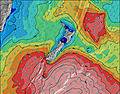 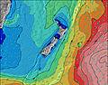 | ||||||||||||||||||||
| Maiores ondas (m) & direção (?) | ||||||||||||||||||||||||
| Período(s) (?) | 8 | 7 | 7 | 8 | 8 | 9 | 9 | 10 | 13 | 13 | 13 | 13 | 13 | 13 | 14 | 14 | 14 | 15 | 9 | 9 | 9 | 10 | 14 | 14 |
Onda (?)Gráfico | ||||||||||||||||||||||||
| 478 | 311 | 295 | 593 | 947 | 1081 | 1156 | 1109 | 2496 | 2458 | 2323 | 2359 | 2187 | 1491 | 2009 | 2005 | 1382 | 1007 | 868 | 940 | 1019 | 1103 | 2480 | 2233 | |
Vento (km/h) | ||||||||||||||||||||||||
| Estado do Vento (?) onshore cruzado-maral Cruzado cruzado-terral terral cristalino | cross- off | cross | cross- off | cross- off | cross- off | cross- off | cross- off | off | off | off | cross- off | cross- off | cross- off | cross- off | cross | cross- on | cross- on | cross- off | cross- off | cross- off | cross- off | cross- off | off | off |
Maré Alta / altura (m) | 1:11AM 3.18 | 1:25PM 3.28 | 1:48AM 3.14 | 2:04PM 3.22 | 2:27AM 3.06 | 2:47PM 3.09 | ||||||||||||||||||
Maré Baixa / altura (m) | 7:16AM 0.29 | 7:39PM 0.25 | 7:54AM 0.32 | 8:19PM 0.32 | 8:35AM 0.41 | 9:03PM 0.45 | ||||||||||||||||||
Sexta-feira 20 | Sábado 21 | Domingo 22 | Seg 23 | |||||||||||||||||||||
| Nascer do sol | - | - | 7:01 | - | - | - | - | - | - | - | 7:03 | - | - | - | - | - | - | - | 7:03 | - | - | - | - | - |
| Pôr do sol | - | - | - | - | - | 8:31 | - | - | - | - | - | - | - | 8:30 | - | - | - | - | - | - | - | 8:29 | - | - |
Chuva (mm) | 1 | - | 2 | 1 | - | - | - | - | - | - | - | - | - | - | - | - | 5 | 5 | - | - | - | - | - | - |
| Temp. °C | 15 | 15 | 16 | 18 | 17 | 16 | 13 | 12 | 12 | 12 | 15 | 16 | 16 | 16 | 14 | 15 | 15 | 15 | 16 | 17 | 17 | 16 | 15 | 15 |
| Feels °C (?) | 12 | 14 | 13 | 11 | 9 | 9 | 8 | 8 | 8 | 9 | 11 | 12 | 12 | 13 | 11 | 12 | 11 | 11 | 11 | 11 | 11 | 12 | 12 | 13 |
- Map Icons:
 Break
Break Live Wave Height (m)
 Live Wind Speed (km/h)
 Surf Rating (10 Max)
 Ocean Swells (m)
- Wind Speed (km/h)
widget de graça do Surf-Forecast.com para o seu site
O relatório de surf / widget do tempo abaixo está disponível para incorporar em sites de terceiros gratuitamente e fornece um resumo das nossas Shingles surf tempo. Simplesmente pegar o trecho de código html que fornecemos e colá-lo em seu próprio site. Você pode escolher seu idioma preferido e unidades métrico/imperial para o surf tempo de alimentação para atender aos usuários do seu site.... Clique aqui para adquirir o código.
 Nearest