Previsão:

Surf em SeransPrevisão / Galicia / Spain
Atualização das previsões em hora min s Forecast update imminent
Estas são ondas em águas abertas. Nas praias as ondas geralmente são menores, especialmente em picos mais abrigados.
A temperatura do mar em Serans hoje é
14.5° C
(O que é normal para esta época do ano)Actualizações em hora min s Forecast update imminent
Quinta-feira 18 | Sexta-feira 19 | Sábado 20 | Dom 21 | |||||||||||||||||||||
| 4 AM | 7 AM | 10 AM | 1 PM | 4 PM | 7 PM | 10 PM | 1 AM | 4 AM | 7 AM | 10 AM | 1 PM | 4 PM | 7 PM | 10 PM | 1 AM | 4 AM | 7 AM | 10 AM | 1 PM | 4 PM | 7 PM | 10 PM | 1 AM | |
Avaliação (10 max) | ||||||||||||||||||||||||
Mapa da altura do Swell |    |  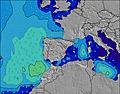 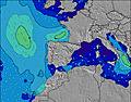 |  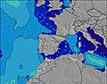 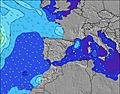 |  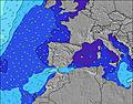 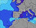 | ||||||||||||||||||||
| Maiores ondas (m) & direção (?) | ||||||||||||||||||||||||
| Período(s) (?) | 23 | 21 | 20 | 19 | 19 | 18 | 17 | 17 | 17 | 16 | 16 | 17 | 17 | 17 | 17 | 16 | 16 | 16 | 13 | 14 | 13 | 13 | 13 | 14 |
Onda (?)Gráfico | ||||||||||||||||||||||||
| 4855 | 16639 | 17647 | 16538 | 17696 | 13991 | 12496 | 10444 | 11788 | 10362 | 9687 | 6936 | 6936 | 6427 | 5600 | 4361 | 3552 | 2808 | 1543 | 3213 | 4970 | 7174 | 8019 | 8880 | |
Vento (km/h) | ||||||||||||||||||||||||
| Estado do Vento (?) onshore cruzado-maral Cruzado cruzado-terral terral cristalino | cross- off | cross- off | cross- off | cross- off | off | cross | cross- on | cross- on | on | on | on | on | on | on | on | glass | off | off | off | cross- off | cross- off | cross | cross | cross |
Maré Alta / altura (m) | 3:03PM 2.59 | 3:19AM 2.80 | 3:40PM 2.65 | 3:55AM 2.87 | 4:16PM 2.68 | |||||||||||||||||||
Maré Baixa / altura (m) | 8:54AM 0.58 | 9:03PM 0.58 | 9:32AM 0.50 | 9:40PM 0.53 | 10:08AM 0.44 | 10:15PM 0.49 | ||||||||||||||||||
Quinta-feira 18 | Sexta-feira 19 | Sábado 20 | Dom 21 | |||||||||||||||||||||
| Nascer do sol | - | - | 9:00 | - | - | - | - | - | - | - | 9:00 | - | - | - | - | - | - | - | 9:02 | - | - | - | - | - |
| Pôr do sol | - | - | - | - | 6:04 | - | - | - | - | - | - | - | 6:04 | - | - | - | - | - | - | - | 6:05 | - | - | - |
Chuva (mm) | - | - | - | 2 | 10 | 26 | 10 | 1 | - | 1 | - | - | - | - | - | - | - | - | - | 11 | 2 | 1 | 1 | 2 |
| Temp. °C | 13 | 13 | 13 | 13 | 13 | 13 | 12 | 11 | 11 | 11 | 10 | 12 | 12 | 11 | 10 | 9 | 10 | 11 | 12 | 12 | 11 | 10 | 10 | 9 |
| Feels °C (?) | 5 | 4 | 3 | 2 | 4 | 12 | 6 | 7 | 7 | 7 | 6 | 8 | 7 | 7 | 7 | 7 | 7 | 5 | 4 | 6 | 1 | 1 | 1 | 1 |
- Map Icons:
 Break
Break Live Wave Height (m)
 Live Wind Speed (km/h)
 Surf Rating (10 Max)
 Ocean Swells (m)
- Wind Speed (km/h)
widget de graça do Surf-Forecast.com para o seu site
O relatório de surf / widget do tempo abaixo está disponível para incorporar em sites de terceiros gratuitamente e fornece um resumo das nossas Serans surf tempo. Simplesmente pegar o trecho de código html que fornecemos e colá-lo em seu próprio site. Você pode escolher seu idioma preferido e unidades métrico/imperial para o surf tempo de alimentação para atender aos usuários do seu site.... Clique aqui para adquirir o código.
 Nearest