Seal Rocks Previsão para Surf
/ NSW – Port Macquarie (37 breaks) / New South Wales (297 breaks) /Previsão:

Surf em Seal RocksPrevisão / NSW – Port Macquarie / Australia
Atualização das previsões em hora min s Forecast update imminent
Estas são ondas em águas abertas. Nas praias as ondas geralmente são menores, especialmente em picos mais abrigados.
A temperatura do mar em Seal Rocks hoje é
23.0° C
(O que é 1.3°C mais quente do que o normal para esta época do ano)Actualizações em hora min s Forecast update imminent
Previsão de curto prazoChuva intensa (total 35mm), mais intensa durante Quarta de manhã. Warm (máx. 20°C na Terça à tarde, mín 17°C na Sexta de manhã). Ventos diminuem (ventos frescos de Este-Sudeste na Quarta à tarde, calmo na Sex de manhã). | ||||||||||||||||||||||||
Tue 12 | Wednesday 13 | Thursday 14 | Fri 15 | |||||||||||||||||||||
1 PM | 4 PM | 7 PM | 10 PM | 1 AM | 4 AM | 7 AM | 10 AM | 1 PM | 4 PM | 7 PM | 10 PM | 1 AM | 4 AM | 7 AM | 10 AM | 1 PM | 4 PM | 7 PM | 10 PM | 1 AM | 4 AM | 7 AM | 10 AM | |
Mapa da altura do Swell |    |    |    |  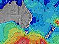 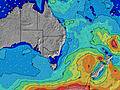 | ||||||||||||||||||||
SSE 11 | SSE 11 | SSE 11 | SSE 10 | SE 7 | SE 7 | SE 7 | SE 7 | SE 7 | SE 7 | SSE 7 | SE 7 | ESE 7 | ESE 7 | ESE 7 | ESE 7 | ESE 7 | ESE 7 | ESE 7 | ESE 7 | ESE 7 | ESE 7 | ESE 7 | ESE 7 | |
711 | 698 | 672 | 653 | 198 | 233 | 234 | 279 | 285 | 309 | 177 | 312 | 266 | 266 | 250 | 243 | 192 | 192 | 176 | 145 | 124 | 124 | 136 | 136 | |
Vento (km/h) | ||||||||||||||||||||||||
Estado do Vento maral cruzado-maral Cruzado cruzado-terral terral cristalino | cross-off | cross-off | cross-off | cross | cross | cross | cross | cross | cross-on | cross | cross | cross-on | cross-on | cross-on | cross-on | cross-on | cross | cross | cross | cross-on | on | glassy | off | off |
Maré Alta | 4:46PM1.27m | 4:36AM1.32m | 5:30PM1.43m | 5:31AM1.32m | 6:14PM1.59m | 6:26AM1.31m | ||||||||||||||||||
Maré Baixa | 10:41PM0.45m | 11:01AM0.15m | 11:40PM0.33m | 11:43AM0.11m | 00:35AM0.21m | |||||||||||||||||||
— | — | — | — | — | 6:30 | — | — | — | — | — | — | — | 6:30 | — | — | — | — | — | — | — | 6:31 | — | — | |
— | 5:01 | — | — | — | — | — | — | — | 5:01 | — | — | — | — | — | — | — | 5:00 | — | — | — | — | — | 5:00 | |
— | — | — | 1 | 1 | — | — | — | 4 | 3 | 3 | 1 | 1 | 3 | 1 | 2 | 2 | 2 | 2 | 4 | 2 | — | — | 1 | |
Temp. °C | 20 | 20 | 20 | 20 | 20 | 19 | 20 | 19 | 19 | 19 | 19 | 20 | 19 | 20 | 20 | 19 | 19 | 19 | 19 | 19 | 19 | 18 | 18 | 17 |
16 | 16 | 15 | 16 | 15 | 14 | 16 | 16 | 15 | 14 | 14 | 16 | 16 | 16 | 16 | 16 | 16 | 15 | 16 | 17 | 19 | 18 | 17 | 17 | |
Swell 1 Altura (m) Direção Período (s) | E 12 | E 12 | E 12 | E 12 | S 10 | S 10 | S 10 | S 10 | S 10 | S 10 | SSE 7 | S 10 | S 10 | S 10 | S 10 | S 10 | S 9 | S 9 | ESE 7 | ESE 7 | ESE 7 | ESE 7 | ESE 7 | ESE 7 |
138 | 138 | 100 | 98 | 164 | 164 | 133 | 102 | 102 | 100 | 177 | 96 | 94 | 68 | 67 | 90 | 78 | 79 | 176 | 145 | 124 | 124 | 136 | 136 | |
Swell 2 Altura (m) Direção Período (s) | NE 10 | NE 10 | S 14 | S 26 | E 12 | E 11 | E 11 | E 11 | E 11 | E 11 | S 10 | S 16 | S 16 | S 15 | S 14 | S 14 | S 13 | E 10 | S 9 | S 9 | S 9 | S 10 | S 9 | S 9 |
4 | 4 | 36 | 13 | 66 | 61 | 60 | 38 | 38 | 37 | 98 | 83 | 78 | 41 | 35 | 33 | 32 | 8 | 79 | 81 | 61 | 64 | 43 | 43 | |
Swell 3 Altura (m) Direção Período (s) | NE 11 | NE 10 | NE 10 | NE 10 | S 25 | S 24 | S 23 | S 22 | S 20 | S 18 | E 11 | E 11 | E 11 | E 11 | E 10 | E 10 | E 10 | — | E 10 | E 10 | E 10 | E 10 | E 10 | E 9 |
4 | 4 | 4 | 4 | 12 | 45 | 42 | 38 | 72 | 57 | 37 | 21 | 21 | 20 | 19 | 19 | 19 | — | 8 | 8 | 17 | 16 | 17 | 16 | |
Ondas de vento Altura (m) Direção Período (s) | SSE 11 | SSE 11 | SSE 11 | SSE 10 | SE 7 | SE 7 | SE 7 | SE 7 | SE 7 | SE 7 | E 6 | SE 7 | ESE 7 | ESE 7 | ESE 7 | ESE 7 | ESE 7 | ESE 7 | — | — | — | — | — | WSW 2 |
711 | 698 | 672 | 653 | 198 | 233 | 234 | 279 | 285 | 309 | 139 | 312 | 266 | 266 | 250 | 243 | 192 | 192 | — | — | — | — | — | 1 | |
Terral ou glassy mais perto | ||||||||||||||||||||||||
Distância (km) | 343 | 343 | 29 | 48 | 93 | 29 | 29 | 48 | 162 | 339 | 166 | 130 | 162 | 162 | 131 | 48 | 162 | 87 | 84 | 29 | 1 | 0 | 0 | 0 |
Melhor previsões de ondas em Port Macquarie | ||||||||||||||||||||||||
Melhor previsões de ondas em Australia | ||||||||||||||||||||||||
Header Global | ||||||||||||||||||||||||
- Map Icons:
 Break
Break Live Wave Height (m)
 Live Wind Speed (km/h)
 Surf Rating (10 Max)
 Ocean Swells (m)
- Wind Speed (km/h)
widget de graça do Surf-Forecast.com para o seu site
O relatório de surf / widget do tempo abaixo está disponível para incorporar em sites de terceiros gratuitamente e fornece um resumo das nossas Seal Rocks surf tempo. Simplesmente pegar o trecho de código html que fornecemos e colá-lo em seu próprio site. Você pode escolher seu idioma preferido e unidades métrico/imperial para o surf tempo de alimentação para atender aos usuários do seu site.... Clique aqui para adquirir o código.
 Nearest