

- Forecast
- Maps
- Live
- Weather State
- Spot Information
Raglan-Manu Bay Surf Forecast
/ Raglan and West Waikato (7 surf breaks) /
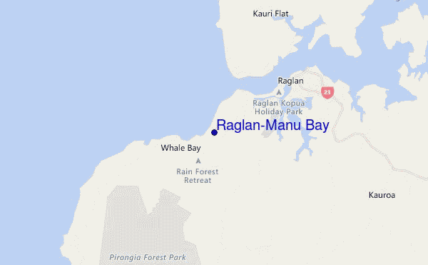
Raglan-Manu Bay surf Forecast / Raglan and West Waikato / New Zealand
- Map Icons:
 Break
Break Live Wave Height (m)
 Live Wind Speed (km/h)
 Surf Rating (10 Max)
 Ocean Swells (m)
- Wind Speed (km/h)
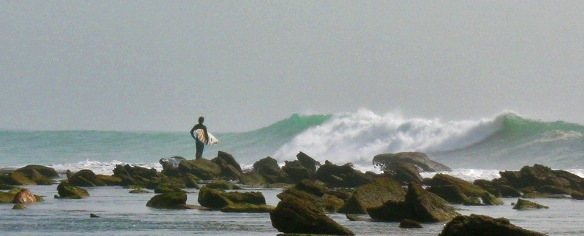
How big are the waves at Raglan-Manu Bay today?
The current surf forecast for Raglan-Manu Bay at 5PM is: 2.3m 14s primary swell from a West-southwest direction and 2.1m 14s secondary swell from a West-southwest direction (forecast issued at 11:00am April 26). The wind direction is predicted to be cross-offshore and the swell rating is 3.
| Time (NZST) & Date | Wave Height | Wave Period |
|---|---|---|
| Morning (26 Apr) | 5.5ft (1.7m) | 15s |
| Afternoon (26 Apr) | 7ft (2.1m) | 14s |
| Evening (26 Apr) | 8ft (2.4m) | 14s |
Table - waves today at Raglan-Manu Bay. (Swell directed towards the surf break)
Friday 26 | Saturday 27 | Sunday 28 | Monday 29 | Tuesday 30 | Wednesday 01 | Thursday 02 | Friday 03 | |||||||||||||||||||||||||||||||||||||||||||||||||||||
| 9 AM | 12 PM | 3 PM | 6 PM | 9 PM | 0 AM | 3 AM | 6 AM | 9 AM | 12 PM | 3 PM | 6 PM | 9 PM | 0 AM | 3 AM | 6 AM | 9 AM | 12 PM | 3 PM | 6 PM | 9 PM | 0 AM | 3 AM | 6 AM | 9 AM | 12 PM | 3 PM | 6 PM | 9 PM | 0 AM | 3 AM | 6 AM | 9 AM | 12 PM | 3 PM | 6 PM | 9 PM | 0 AM | 3 AM | 6 AM | 9 AM | 12 PM | 3 PM | 6 PM | 9 PM | 0 AM | 3 AM | 6 AM | 9 AM | 12 PM | 3 PM | 6 PM | 9 PM | 0 AM | 3 AM | 6 AM | 9 AM | 12 PM | 3 PM | 6 PM | |
Rating (10 max) | ||||||||||||||||||||||||||||||||||||||||||||||||||||||||||||
Swell Height Map |    |    |    |  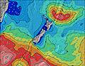 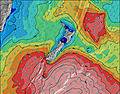 |  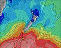 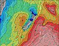 |  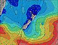 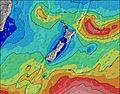 |  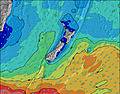 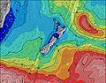 | 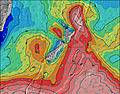 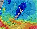 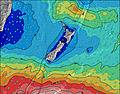 | ||||||||||||||||||||||||||||||||||||||||||||||||||||
| Wave Height (m) & direction (?) | ||||||||||||||||||||||||||||||||||||||||||||||||||||||||||||
| Period(s) (?) | 15 | 15 | 14 | 14 | 14 | 12 | 13 | 14 | 14 | 15 | 15 | 15 | 15 | 15 | 15 | 14 | 14 | 14 | 14 | 14 | 14 | 13 | 13 | 13 | 13 | 12 | 12 | 12 | 12 | 12 | 12 | 12 | 14 | 14 | 14 | 14 | 14 | 14 | 14 | 14 | 14 | 14 | 14 | 13 | 13 | 13 | 13 | 13 | 16 | 16 | 15 | 15 | 14 | 14 | 14 | 14 | 13 | 13 | 13 | 13 |
Wave (?)Graph | ||||||||||||||||||||||||||||||||||||||||||||||||||||||||||||
| Energy (?) | 1223 | 1659 | 1797 | 2167 | 2312 | 2163 | 2586 | 3158 | 3248 | 3385 | 3207 | 2880 | 2675 | 2290 | 2111 | 1690 | 1517 | 1171 | 1032 | 892 | 704 | 586 | 577 | 569 | 476 | 447 | 359 | 353 | 353 | 211 | 171 | 171 | 384 | 487 | 487 | 487 | 474 | 362 | 362 | 352 | 352 | 367 | 415 | 402 | 475 | 506 | 569 | 596 | 1375 | 1393 | 1271 | 1220 | 1061 | 930 | 862 | 714 | 595 | 586 | 506 | 514 |
Wind (km/h) | ||||||||||||||||||||||||||||||||||||||||||||||||||||||||||||
| Wind State (?) onshore cross-onshore cross-shore cross-offshore offshore glassy | cross- on | cross- on | cross- on | cross | cross | cross | cross- off | cross- off | cross- off | cross- off | cross | cross- off | cross | cross- off | off | cross- off | cross- off | cross | glass | glass | cross | cross- off | cross- off | cross- off | cross- off | cross- off | cross- off | cross- off | cross- off | off | off | off | off | off | cross- off | cross- off | cross- off | cross- off | cross- off | cross- off | cross- off | cross- off | cross- off | cross- off | cross- off | cross- off | cross- off | cross | cross | cross | cross | cross | glass | cross- off | cross- off | cross- off | cross- off | cross- off | cross | cross |
High Tide / height (m) | 11:28AM 2.80 | 11:46PM 2.87 | 12:02PM 2.73 | 12:22AM 2.80 | 12:41PM 2.63 | 1:04AM 2.70 | 1:28PM 2.51 | 1:56AM 2.57 | 2:31PM 2.39 | 3:02AM 2.48 | 3:47PM 2.33 | 4:18AM 2.46 | 4:58PM 2.36 | 5:29AM 2.54 | ||||||||||||||||||||||||||||||||||||||||||||||
Low Tide / height (m) | 5:42PM 0.30 | 6:00AM 0.45 | 6:19PM 0.41 | 6:40AM 0.57 | 7:00PM 0.54 | 7:27AM 0.70 | 7:47PM 0.68 | 8:24AM 0.80 | 8:46PM 0.78 | 9:30AM 0.84 | 9:57PM 0.82 | 10:42AM 0.79 | 11:10PM 0.75 | 11:52AM 0.64 | ||||||||||||||||||||||||||||||||||||||||||||||
Friday 26 | Saturday 27 | Sunday 28 | Monday 29 | Tuesday 30 | Wednesday 01 | Thursday 02 | Friday 03 | |||||||||||||||||||||||||||||||||||||||||||||||||||||
| Sunrise | 6:56 | - | - | - | - | - | - | - | 6:58 | - | - | - | - | - | - | - | 6:58 | - | - | - | - | - | - | - | 7:00 | - | - | - | - | - | - | - | 7:01 | - | - | - | - | - | - | - | 7:01 | - | - | - | - | - | - | - | 7:03 | - | - | - | - | - | - | - | 7:03 | - | - | - |
| Sunset | - | - | 5:37 | - | - | - | - | - | - | - | 5:37 | - | - | - | - | - | - | - | 5:36 | - | - | - | - | - | - | - | 5:35 | - | - | - | - | - | - | - | 5:32 | - | - | - | - | - | - | - | 5:31 | - | - | - | - | - | - | - | 5:30 | - | - | - | - | - | - | - | 5:30 | - |
Rain (mm) | 2 | 1 | - | 1 | - | - | - | - | - | - | - | - | - | - | - | - | - | - | - | - | - | - | - | - | - | - | - | - | - | - | - | - | - | - | - | - | - | - | - | - | - | - | - | - | - | - | - | - | - | - | - | - | - | - | - | - | - | - | 1 | 1 |
| Temp. °C | 16 | 17 | 17 | 15 | 14 | 14 | 14 | 13 | 14 | 14 | 15 | 14 | 14 | 14 | 13 | 12 | 12 | 15 | 16 | 16 | 15 | 14 | 13 | 13 | 13 | 16 | 18 | 15 | 15 | 14 | 13 | 13 | 14 | 16 | 18 | 16 | 15 | 14 | 13 | 13 | 14 | 16 | 18 | 16 | 14 | 13 | 14 | 14 | 14 | 15 | 15 | 13 | 12 | 11 | 10 | 10 | 11 | 15 | 15 | 14 |
| Feels °C (?) | 14 | 13 | 12 | 9 | 8 | 8 | 8 | 8 | 10 | 10 | 10 | 10 | 11 | 12 | 11 | 10 | 9 | 13 | 14 | 14 | 12 | 12 | 10 | 10 | 10 | 12 | 14 | 13 | 13 | 11 | 10 | 11 | 12 | 14 | 15 | 13 | 12 | 10 | 8 | 8 | 10 | 13 | 13 | 12 | 9 | 9 | 11 | 10 | 10 | 11 | 11 | 10 | 10 | 9 | 7 | 7 | 8 | 12 | 13 | 13 |
FREE! Surf-Forecast.com widget for your website
The surf report / weather widget below is available to embed on third party websites free of charge and provides a summary of our Raglan-Manu Bay surf forecast. Simply grab the html code snippet that we provide and paste it into your own site. You can choose your preferred language and metric/imperial units for the surf forecast feed to suit users of your site. Click here to get the code.


 Nearest