

- Forecast
- Maps
- Live
- Weather State
- Spot Information
Ohiwa-Port Ohope Surf Forecast
/ Bay of Plenty (18 surf breaks) /
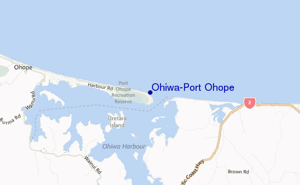
Ohiwa-Port Ohope surf Forecast / Bay of Plenty / New Zealand
- Map Icons:
 Break
Break Live Wave Height (m)
 Live Wind Speed (km/h)
 Surf Rating (10 Max)
 Ocean Swells (m)
- Wind Speed (km/h)
How big are the waves at Ohiwa-Port Ohope today?
The current surf forecast for Ohiwa-Port Ohope at 11PM is: 1.0m 5s primary swell from a North-northwest direction and 0.3m 12s secondary swell from a North-northeast direction, 0.1m 9s secondary swell from a Northeast direction (forecast issued at 05:00pm April 25). The wind direction is predicted to be cross-onshore.
| Time (NZST) & Date | Wave Height | Wave Period |
|---|---|---|
| Morning (25 Apr) | - | - |
| Afternoon (25 Apr) | 1ft (0.3m) | 12s |
| Evening (25 Apr) | 3.5ft (1.0m) | 5s |
Table - waves today at Ohiwa-Port Ohope. (Swell directed towards the surf break)
 Recent Eyeball Surf Reports for Bay of Plenty
Thursday 25 | Friday 26 | Saturday 27 | Sunday 28 | Monday 29 | Tuesday 30 | Wednesday 01 | Thursday 02 | Fri 03 | ||||||||||||||||||||||||||||||||||||||||||||||||||||
| 3 PM | 6 PM | 9 PM | 0 AM | 3 AM | 6 AM | 9 AM | 12 PM | 3 PM | 6 PM | 9 PM | 0 AM | 3 AM | 6 AM | 9 AM | 12 PM | 3 PM | 6 PM | 9 PM | 0 AM | 3 AM | 6 AM | 9 AM | 12 PM | 3 PM | 6 PM | 9 PM | 0 AM | 3 AM | 6 AM | 9 AM | 12 PM | 3 PM | 6 PM | 9 PM | 0 AM | 3 AM | 6 AM | 9 AM | 12 PM | 3 PM | 6 PM | 9 PM | 0 AM | 3 AM | 6 AM | 9 AM | 12 PM | 3 PM | 6 PM | 9 PM | 0 AM | 3 AM | 6 AM | 9 AM | 12 PM | 3 PM | 6 PM | 9 PM | 0 AM | |
Rating (10 max) | ||||||||||||||||||||||||||||||||||||||||||||||||||||||||||||
Swell Height Map |    |    |    |    |    |    |    |    |   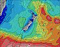 | |||||||||||||||||||||||||||||||||||||||||||||||||||
| Wave Height (m) & direction (?) | ||||||||||||||||||||||||||||||||||||||||||||||||||||||||||||
| Period(s) (?) | 12 | 12 | 5 | 5 | 5 | 5 | 5 | 5 | 5 | 6 | 6 | 7 | 11 | 10 | 10 | 10 | 10 | 10 | 10 | 9 | 9 | 10 | 10 | 9 | 9 | 9 | 9 | 9 | 9 | 9 | 8 | 8 | 8 | 7 | 7 | 8 | 8 | 8 | 8 | 8 | 9 | 9 | 9 | 9 | 10 | 10 | 10 | 10 | 10 | 10 | 10 | 12 | 11 | 11 | 11 | 11 | 11 | 11 | 11 | 11 |
Wave (?)Graph | ||||||||||||||||||||||||||||||||||||||||||||||||||||||||||||
| Energy (?) | 29 | 29 | 40 | 56 | 55 | 55 | 69 | 88 | 74 | 67 | 74 | 70 | 238 | 331 | 380 | 394 | 339 | 356 | 307 | 258 | 258 | 230 | 230 | 173 | 166 | 162 | 99 | 79 | 109 | 104 | 69 | 82 | 77 | 86 | 104 | 131 | 163 | 191 | 219 | 224 | 240 | 318 | 359 | 375 | 391 | 408 | 433 | 520 | 541 | 527 | 286 | 644 | 604 | 503 | 458 | 386 | 302 | 230 | 176 | 135 |
Wind (km/h) | ||||||||||||||||||||||||||||||||||||||||||||||||||||||||||||
| Wind State (?) onshore cross-onshore cross-shore cross-offshore offshore glassy | cross- on | cross- on | cross- on | cross | cross- on | cross- on | cross | cross- on | cross- on | cross- off | cross- off | cross- off | off | off | off | glass | cross- on | glass | glass | cross- off | cross- off | cross- off | cross- off | cross- on | cross- on | glass | cross | cross- off | cross- off | cross- off | cross- off | glass | cross- on | cross- off | cross- off | cross- off | cross- off | cross- off | cross- off | cross- off | cross- off | cross- off | cross- off | cross- off | cross- off | cross- off | cross- off | cross | cross- off | cross- off | cross- off | cross- off | cross- off | cross- off | cross- off | cross- on | on | glass | glass | glass |
High Tide / height (m) | 8:23PM 1.78 | 8:30AM 1.72 | 9:01PM 1.80 | 9:14AM 1.72 | 9:41PM 1.81 | 9:59AM 1.73 | 10:24PM 1.80 | 10:42AM 1.75 | 11:12PM 1.79 | 11:25AM 1.76 | 12:05AM 1.79 | 12:11PM 1.76 | 1:00AM 1.81 | 1:05PM 1.75 | ||||||||||||||||||||||||||||||||||||||||||||||
Low Tide / height (m) | 2:24PM 0.46 | 2:43AM 0.56 | 3:02PM 0.46 | 3:25AM 0.55 | 3:42PM 0.48 | 4:08AM 0.56 | 4:24PM 0.51 | 4:52AM 0.58 | 5:09PM 0.53 | 5:40AM 0.61 | 5:56PM 0.53 | 6:34AM 0.63 | 6:47PM 0.54 | 7:31AM 0.62 | 7:41PM 0.54 | |||||||||||||||||||||||||||||||||||||||||||||
Thursday 25 | Friday 26 | Saturday 27 | Sunday 28 | Monday 29 | Tuesday 30 | Wednesday 01 | Thursday 02 | Fri 03 | ||||||||||||||||||||||||||||||||||||||||||||||||||||
| Sunrise | - | - | - | - | - | - | 6:48 | - | - | - | - | - | - | - | 6:48 | - | - | - | - | - | - | - | 6:50 | - | - | - | - | - | - | - | 6:50 | - | - | - | - | - | - | - | 6:52 | - | - | - | - | - | - | - | 6:52 | - | - | - | - | - | - | - | 6:54 | - | - | - | - | - |
| Sunset | 5:30 | - | - | - | - | - | - | - | 5:29 | - | - | - | - | - | - | - | 5:27 | - | - | - | - | - | - | - | 5:25 | - | - | - | - | - | - | - | 5:24 | - | - | - | - | - | - | - | 5:23 | - | - | - | - | - | - | - | 5:22 | - | - | - | - | - | - | - | 5:22 | - | - | - |
Rain (mm) | - | - | 1 | 1 | 1 | 2 | 2 | 1 | - | 1 | - | - | - | - | - | - | - | - | - | - | - | - | - | - | - | - | - | - | - | - | - | - | - | - | - | - | - | - | - | - | - | - | - | - | - | - | - | - | - | 1 | 2 | 5 | 1 | - | - | 1 | - | - | - | - |
| Temp. °C | 14 | 14 | 16 | 15 | 15 | 15 | 17 | 19 | 18 | 15 | 13 | 10 | 8 | 8 | 10 | 15 | 16 | 14 | 12 | 12 | 12 | 12 | 13 | 16 | 16 | 15 | 14 | 13 | 12 | 12 | 13 | 17 | 16 | 15 | 14 | 14 | 14 | 14 | 14 | 17 | 18 | 16 | 16 | 16 | 16 | 16 | 17 | 19 | 18 | 17 | 16 | 16 | 17 | 17 | 18 | 19 | 19 | 17 | 16 | 15 |
| Feels °C (?) | 12 | 13 | 14 | 14 | 14 | 14 | 16 | 18 | 16 | 14 | 12 | 6 | 4 | 4 | 7 | 12 | 12 | 12 | 10 | 10 | 10 | 10 | 11 | 14 | 14 | 14 | 12 | 11 | 10 | 10 | 10 | 15 | 14 | 12 | 11 | 12 | 12 | 12 | 11 | 14 | 14 | 12 | 13 | 12 | 13 | 13 | 13 | 15 | 14 | 13 | 12 | 13 | 17 | 17 | 18 | 18 | 19 | 18 | 17 | 15 |
FREE! Surf-Forecast.com widget for your website
The surf report / weather widget below is available to embed on third party websites free of charge and provides a summary of our Ohiwa-Port Ohope surf forecast. Simply grab the html code snippet that we provide and paste it into your own site. You can choose your preferred language and metric/imperial units for the surf forecast feed to suit users of your site. Click here to get the code.


 Nearest