- Forecast
- Maps
- Live
- Weather State
- Spot Information
Morro do Maluf Previsão de Surf
/ São Paulo (84 surf breaks) /
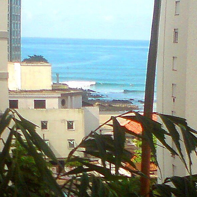
Surf em Morro do MalufPrevisão / São Paulo / Brazil
Previsão de curto prazo: principalmente seco. Warm (máx. 27°C no Domingo de manhã, mín 17°C na Seg à noite). o vento será geralmente fraco. | Dias 3-6 Resumo do Tempo chuva moderada (total 18mm), mais intensa na Sexta à tarde. Warm (máx. 20°C na Quarta à tarde, mín 18°C na Terça à noite). o vento será geralmente fraco. | |||||||||||||||||||||
Domingo 03 | Segunda-feira 04 | Terça-feira 05 | Quarta-feira 06 | Quinta-feira 07 | Sexta-feira 08 | Sáb 09 | ||||||||||||||||
| noite | manhã | tarde | noite | manhã | tarde | noite | manhã | tarde | noite | manhã | tarde | noite | manhã | tarde | noite | manhã | tarde | noite | manhã | tarde | ||
Avaliação (10 max) | ||||||||||||||||||||||
Mapa da altura do Swell |  |  |  |  |  |  |  |  | ||||||||||||||
| Maiores ondas (m) & direção (?) | ||||||||||||||||||||||
| Período(s) (?) | 6 | 7 | 7 | 7 | 7 | 8 | 7 | 15 | 13 | 9 | 9 | 17 | 15 | 14 | 13 | 13 | 12 | 12 | 6 | 9 | 9 | |
Onda (?)Gráfico | ||||||||||||||||||||||
| Energia (?) | 170 | 83 | 75 | 53 | 37 | 47 | 40 | 55 | 78 | 233 | 182 | 424 | 645 | 531 | 408 | 327 | 235 | 180 | 183 | 353 | 516 | |
Vento (km/h) | ||||||||||||||||||||||
| Estado do Vento (?) onshore cruzado-maral Cruzado cruzado-terral terral cristalino | off | cross- off | cross- off | glass | on | on | cross- on | cross- on | on | cross- on | glass | cross- on | glass | glass | on | cross- on | glass | on | on | on | on | |
Maré Alta / altura (m) | 12:24PM 0.81 | 9:20PM 0.72 | 1:06PM 0.92 | 12:23AM 0.78 | 1:35PM 1.03 | 1:01AM 0.89 | 2:01PM 1.13 | 1:30AM 0.99 | 2:26PM 1.20 | 1:58AM 1.10 | 2:52PM 1.25 | 2:27AM 1.19 | 3:18PM 1.28 | |||||||||
Maré Baixa / altura (m) | 3:57AM 0.46 | 5:16PM 0.59 | 5:22AM 0.39 | 6:28PM 0.51 | 6:25AM 0.28 | 7:17PM 0.43 | 7:14AM 0.16 | 7:56PM 0.35 | 7:56AM 0.05 | 8:32PM 0.30 | 8:36AM -0.03 | 9:06PM 0.28 | 9:13AM -0.08 | |||||||||
Domingo 03 | Segunda-feira 04 | Terça-feira 05 | Quarta-feira 06 | Quinta-feira 07 | Sexta-feira 08 | Sáb 09 | ||||||||||||||||
| Nascer do sol | - | 6:39 | - | - | 6:39 | - | - | 6:37 | - | - | 6:37 | - | - | 6:37 | - | - | 6:35 | - | - | 6:35 | - | |
| Pôr do sol | - | - | 5:42 | - | - | 5:43 | - | - | 5:43 | - | - | 5:44 | - | - | 5:44 | - | - | 5:44 | - | - | 5:45 | |
Chuva (mm) | - | - | - | - | - | - | - | - | - | - | - | - | 1 | - | 1 | 3 | - | 13 | 25 | 2 | 1 | |
| Temp. °C | 21 | 27 | 26 | 23 | 20 | 20 | 18 | 19 | 18 | 18 | 19 | 20 | 20 | 19 | 19 | 19 | 20 | 19 | 18 | 17 | 17 | |
| Feels °C (?) | 20 | 23 | 22 | 22 | 17 | 19 | 18 | 18 | 16 | 18 | 21 | 20 | 21 | 19 | 19 | 19 | 22 | 19 | 14 | 13 | 12 | |
- Map Icons:
 Break
Break Live Wave Height (m)
 Live Wind Speed (km/h)
 Surf Rating (10 Max)
 Ocean Swells (m)
- Wind Speed (km/h)
 Relatórios Recentes de Surf dos Informantes São Paulo

1 h 27 min ago
widget de graça do Surf-Forecast.com para o seu site
O relatório de surf / widget do tempo abaixo está disponível para incorporar em sites de terceiros gratuitamente e fornece um resumo das nossas Morro do Maluf surf tempo. Simplesmente pegar o trecho de código html que fornecemos e colá-lo em seu próprio site. Você pode escolher seu idioma preferido e unidades métrico/imperial para o surf tempo de alimentação para atender aos usuários do seu site.... Clique aqui para adquirir o código.
Informação sobre a previsão de Surf de Morro do Maluf
A previsão para surf acima mencionada para Morro do Maluf proporciona informações essenciais para determinar se as condições de surf serão boas nos próximos 12 dias. Um guia geral para surfar em Morro do Maluf pode ser encontrado selecionando a opção guia local para surf no menu cinza. Nossa previsão de surf em Morro do Maluf é sem igual, pois inclui a energia da onda (poder)que define a sensação real do surf, ao invés de incluir somente a altura ou o período das ondas. Se você surfa com regularidade no mesmo lugar (Morro do Maluf), então faça uma anotação mental da energia da onda indicada na tabela de previsão do surf a cada vez que você for lá. Em pouco tempo você talvez comece a escolher seus dias de surf baseado somente na energia da onda, combinado com nossa previsão de condições favoráveis de vento terral classificação por estrelas ajudará nisto e, com certeza, você também encontrará a altura usual de ondas e prognósticos do período das ondas em nossa previsão para o surf, assim como a quebra dos componentes do swell sob nossas opções de usuário avançadas (para revelar isto, clique no título caractere de Einstein em horários da maré).
Informações adicionais sobre perguntas frequentes a cerca nossa previsão do surf em Morro do Maluf podem ser encontradas embaixo da aba de ajuda no menú ao topo e também ao mover o mouse sobre as question marks na própria tabela de previsão do surf. Por favor, sempre tenha em mente que a previsão é para águas abertas próximas à costa e que fatores locais em cada surf break influenciam na real altura da onda, como o perfil da praia ou do recife, profundidades da água fora da costa e abrigo.
Morro do Maluf is 17 km (11 miles) from the city of Bertioga. If you plan a holiday in São Paulo, look for hotels and other accommodation in Bertioga. Bertioga has rooms for a wide range of budgets as well as car hire and transport links.


 Nearest