Doran Beach Previsão para Surf
/ CAL – Sonoma (10 breaks) / California (404 breaks) /Previsão:


Surf em Doran BeachPrevisão / CAL – Sonoma / USA
Atualização das previsões em hora min s Forecast update imminent
Estas são ondas em águas abertas. Nas praias as ondas geralmente são menores, especialmente em picos mais abrigados.
A temperatura do mar em Doran Beach hoje é
12.8° C
(O que é um pouco mais quente que o habitual)Actualizações em hora min s Forecast update imminent
Sábado 17 | Domingo 18 | Segunda-feira 19 | Ter 20 | |||||||||||||||||||||
| 7 AM | 10 AM | 1 PM | 4 PM | 7 PM | 10 PM | 1 AM | 4 AM | 7 AM | 10 AM | 1 PM | 4 PM | 7 PM | 10 PM | 1 AM | 4 AM | 7 AM | 10 AM | 1 PM | 4 PM | 7 PM | 10 PM | 1 AM | 4 AM | |
Avaliação (10 max) | ||||||||||||||||||||||||
Mapa da altura do Swell |  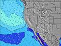  |    |    |  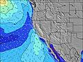 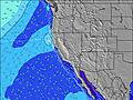 | ||||||||||||||||||||
| Maiores ondas (m) & direção (?) | ||||||||||||||||||||||||
| Período(s) (?) | 12 | 12 | 18 | 17 | 16 | 16 | 15 | 15 | 15 | 14 | 14 | 13 | 13 | 13 | 14 | 14 | 14 | 14 | 13 | 13 | 13 | 13 | 14 | 18 |
Onda (?)Gráfico | ||||||||||||||||||||||||
| 186 | 179 | 163 | 220 | 267 | 422 | 367 | 428 | 723 | 674 | 618 | 609 | 609 | 539 | 547 | 596 | 507 | 326 | 246 | 246 | 192 | 186 | 331 | 418 | |
Vento (km/h) | ||||||||||||||||||||||||
| Estado do Vento (?) onshore cruzado-maral Cruzado cruzado-terral terral cristalino | cross- off | cross- off | cross- off | glass | glass | cross- off | cross- off | cross- off | cross- off | cross- off | glass | cross- off | glass | glass | cross- off | cross- off | cross- off | glass | glass | cross- off | glass | glass | cross- off | cross- off |
Maré Alta / altura (m) | 9:11AM 1.83 | 11:35PM 1.37 | 9:50AM 1.83 | 12:03AM 1.38 | 10:29AM 1.81 | 12:31AM 1.41 | ||||||||||||||||||
Maré Baixa / altura (m) | 4:39PM -0.16 | 4:20AM 0.98 | 5:11PM -0.20 | 4:56AM 0.93 | 5:42PM -0.20 | |||||||||||||||||||
Sábado 17 | Domingo 18 | Segunda-feira 19 | Ter 20 | |||||||||||||||||||||
| Nascer do sol | - | 7:26 | - | - | - | - | - | - | - | 7:26 | - | - | - | - | - | - | - | 7:26 | - | - | - | - | - | - |
| Pôr do sol | - | - | - | 5:16 | - | - | - | - | - | - | - | 5:17 | - | - | - | - | - | - | - | 5:19 | - | - | - | - |
Chuva (mm) | - | - | - | - | - | - | - | - | - | - | - | - | - | - | - | - | - | - | - | - | - | - | - | - |
| Temp. °C | 12 | 13 | 17 | 17 | 15 | 14 | 14 | 14 | 13 | 14 | 17 | 16 | 15 | 14 | 13 | 12 | 12 | 13 | 17 | 15 | 13 | 12 | 12 | 12 |
| Feels °C (?) | 9 | 9 | 14 | 16 | 14 | 12 | 11 | 11 | 9 | 11 | 15 | 14 | 13 | 12 | 11 | 10 | 9 | 11 | 15 | 13 | 12 | 11 | 10 | 10 |
- Map Icons:
 Break
Break Live Wave Height (m)
 Live Wind Speed (km/h)
 Surf Rating (10 Max)
 Ocean Swells (m)
- Wind Speed (km/h)
widget de graça do Surf-Forecast.com para o seu site
O relatório de surf / widget do tempo abaixo está disponível para incorporar em sites de terceiros gratuitamente e fornece um resumo das nossas Doran Beach surf tempo. Simplesmente pegar o trecho de código html que fornecemos e colá-lo em seu próprio site. Você pode escolher seu idioma preferido e unidades métrico/imperial para o surf tempo de alimentação para atender aos usuários do seu site.... Clique aqui para adquirir o código.
 Nearest