Previsão:

Surf em Cavalos de FaoPrevisão / Douro & Minho / Portugal
Atualização das previsões em hora min s Forecast update imminent
Estas são ondas em águas abertas. Nas praias as ondas geralmente são menores, especialmente em picos mais abrigados.
A temperatura do mar em Cavalos de Fao hoje é
13.9° C
(O que é um pouco mais frio que o normal)Actualizações em hora min s Forecast update imminent
Sábado 10 | Domingo 11 | Segunda-feira 12 | Terça-feira 13 | |||||||||||||||||||||
| 9 AM | 12 PM | 3 PM | 6 PM | 9 PM | 0 AM | 3 AM | 6 AM | 9 AM | 12 PM | 3 PM | 6 PM | 9 PM | 0 AM | 3 AM | 6 AM | 9 AM | 12 PM | 3 PM | 6 PM | 9 PM | 0 AM | 3 AM | 6 AM | |
Avaliação (10 max) | ||||||||||||||||||||||||
Mapa da altura do Swell |    |  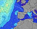 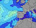 |  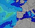 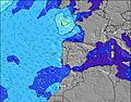 | 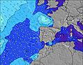 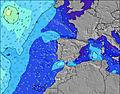 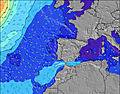 | ||||||||||||||||||||
| Maiores ondas (m) & direção (?) | ||||||||||||||||||||||||
| Período(s) (?) | 12 | 12 | 12 | 13 | 13 | 13 | 12 | 12 | 12 | 11 | 10 | 10 | 10 | 11 | 11 | 11 | 11 | 11 | 11 | 11 | 11 | 11 | 11 | 12 |
Onda (?)Gráfico | ||||||||||||||||||||||||
| 1787 | 2348 | 2267 | 2107 | 2046 | 1799 | 1323 | 905 | 844 | 759 | 616 | 757 | 988 | 1102 | 1583 | 2331 | 2184 | 2322 | 2248 | 1933 | 4009 | 2116 | 1165 | 1180 | |
Vento (km/h) | ||||||||||||||||||||||||
| Estado do Vento (?) onshore cruzado-maral Cruzado cruzado-terral terral cristalino | off | cross- off | cross | cross | cross- off | cross- off | cross- off | cross- off | cross- off | cross- off | cross | cross | cross | cross- off | cross | cross | cross | cross | cross | cross- off | cross- off | cross- off | cross | cross |
Maré Alta / altura (m) | 7:42AM 2.44 | 8:17PM 2.21 | 8:38AM 2.24 | 9:18PM 2.14 | 9:45AM 2.11 | 10:28PM 2.13 | ||||||||||||||||||
Maré Baixa / altura (m) | 2:00PM 0.76 | 2:17AM 0.92 | 2:55PM 0.91 | 3:27AM 1.03 | 4:01PM 1.00 | 4:44AM 1.04 | ||||||||||||||||||
Sábado 10 | Domingo 11 | Segunda-feira 12 | Terça-feira 13 | |||||||||||||||||||||
| Nascer do sol | 8:00 | - | - | - | - | - | - | - | 8:00 | - | - | - | - | - | - | - | 8:00 | - | - | - | - | - | - | - |
| Pôr do sol | - | - | 5:23 | - | - | - | - | - | - | - | 5:24 | - | - | - | - | - | - | - | 5:25 | - | - | - | - | - |
Chuva (mm) | - | - | - | - | - | - | - | - | - | - | - | 1 | 1 | 1 | - | - | 1 | - | 2 | - | 1 | 4 | 6 | 10 |
| Temp. °C | 10 | 11 | 11 | 11 | 11 | 10 | 10 | 10 | 11 | 12 | 13 | 14 | 14 | 13 | 13 | 13 | 13 | 13 | 13 | 14 | 13 | 13 | 12 | 12 |
| Feels °C (?) | 8 | 9 | 8 | 9 | 8 | 6 | 6 | 6 | 6 | 7 | 8 | 10 | 9 | 8 | 7 | 7 | 6 | 5 | 5 | 7 | 5 | 5 | 4 | 6 |
- Map Icons:
 Break
Break Live Wave Height (m)
 Live Wind Speed (km/h)
 Surf Rating (10 Max)
 Ocean Swells (m)
- Wind Speed (km/h)
widget de graça do Surf-Forecast.com para o seu site
O relatório de surf / widget do tempo abaixo está disponível para incorporar em sites de terceiros gratuitamente e fornece um resumo das nossas Cavalos de Fao surf tempo. Simplesmente pegar o trecho de código html que fornecemos e colá-lo em seu próprio site. Você pode escolher seu idioma preferido e unidades métrico/imperial para o surf tempo de alimentação para atender aos usuários do seu site.... Clique aqui para adquirir o código.
 Nearest