- Forecast
- Maps
- Live
- Weather State
- Spot Information
Bandy Creek groyne Previsão para Surf
/ WA – Far South (31 breaks) / Western Australia (159 breaks) /Previsão:

Surf em Bandy Creek groynePrevisão / WA – Far South / Australia
Atualização das previsões em hora min s Forecast update imminent
Estas são ondas em águas abertas. Nas praias as ondas geralmente são menores, especialmente em picos mais abrigados.
A temperatura do mar em Bandy Creek groyne hoje é
18.4° C
(O que é 1.9°C mais quente do que o normal para esta época do ano)Actualizações em hora min s Forecast update imminent
Quarta-feira 05 | Quinta-feira 06 | Sexta-feira 07 | Sábado 08 | |||||||||||||||||||||
| 11 AM | 2 PM | 5 PM | 8 PM | 11 PM | 2 AM | 5 AM | 8 AM | 11 AM | 2 PM | 5 PM | 8 PM | 11 PM | 2 AM | 5 AM | 8 AM | 11 AM | 2 PM | 5 PM | 8 PM | 11 PM | 2 AM | 5 AM | 8 AM | |
Avaliação (10 max) | ||||||||||||||||||||||||
Mapa da altura do Swell |    | 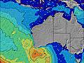 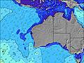 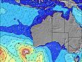 | 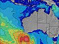 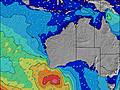 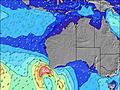 | 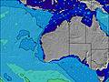 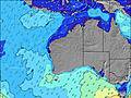 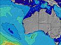 | ||||||||||||||||||||
| Maiores ondas (m) & direção (?) | ||||||||||||||||||||||||
| Período(s) (?) | 15 | 15 | 15 | 14 | 14 | 14 | 14 | 14 | 14 | 14 | 14 | 14 | 14 | 13 | 14 | 14 | 14 | 14 | 16 | 16 | 16 | 16 | 15 | 14 |
Onda (?)Gráfico | ||||||||||||||||||||||||
| 627 | 754 | 522 | 508 | 487 | 459 | 494 | 1138 | 1126 | 1078 | 849 | 1247 | 1122 | 817 | 714 | 433 | 721 | 822 | 1055 | 1281 | 1265 | 1102 | 970 | 813 | |
Vento (km/h) | ||||||||||||||||||||||||
| Estado do Vento (?) onshore cruzado-maral Cruzado cruzado-terral terral cristalino | cross- off | cross | cross | cross | cross- off | cross- off | cross- on | on | on | on | on | on | on | on | on | on | cross- on | cross- on | cross- on | cross- on | cross | cross- on | cross | cross- on |
Maré Alta / altura (m) | 11:05AM 0.64 | 10:33PM 1.11 | 11:40AM 0.54 | 11:00PM 1.14 | 12:07PM 0.42 | 11:25PM 1.13 | ||||||||||||||||||
Maré Baixa / altura (m) | 3:51PM 0.39 | 5:57AM 0.17 | 3:46PM 0.39 | 6:48AM 0.20 | 3:25PM 0.36 | 7:53AM 0.26 | ||||||||||||||||||
Quarta-feira 05 | Quinta-feira 06 | Sexta-feira 07 | Sábado 08 | |||||||||||||||||||||
| Nascer do sol | - | - | - | - | - | - | 4:48 | - | - | - | - | - | - | - | 4:47 | - | - | - | - | - | - | - | 4:46 | - |
| Pôr do sol | - | - | 6:22 | - | - | - | - | - | - | - | 6:23 | - | - | - | - | - | - | - | 6:24 | - | - | - | - | - |
Chuva (mm) | - | 2 | - | - | - | - | - | 2 | 1 | 1 | 1 | 1 | - | - | - | - | 1 | - | - | - | - | - | - | - |
| Temp. °C | 19 | 18 | 19 | 17 | 16 | 15 | 15 | 16 | 16 | 17 | 16 | 15 | 15 | 14 | 15 | 15 | 15 | 15 | 15 | 14 | 13 | 13 | 13 | 14 |
| Feels °C (?) | 15 | 14 | 15 | 14 | 15 | 15 | 13 | 11 | 12 | 12 | 11 | 10 | 11 | 10 | 11 | 11 | 10 | 10 | 10 | 10 | 9 | 9 | 10 | 9 |
- Map Icons:
 Break
Break Live Wave Height (m)
 Live Wind Speed (km/h)
 Surf Rating (10 Max)
 Ocean Swells (m)
- Wind Speed (km/h)
widget de graça do Surf-Forecast.com para o seu site
O relatório de surf / widget do tempo abaixo está disponível para incorporar em sites de terceiros gratuitamente e fornece um resumo das nossas Bandy Creek groyne surf tempo. Simplesmente pegar o trecho de código html que fornecemos e colá-lo em seu próprio site. Você pode escolher seu idioma preferido e unidades métrico/imperial para o surf tempo de alimentação para atender aos usuários do seu site.... Clique aqui para adquirir o código.
 Nearest