
Previsão:

Previsão de curto prazoChuva intensa (total 21mm), mais intensa durante Segunda à tarde. Warm (máx. 30°C na Terça à tarde, mín 18°C na Seg à noite). Ventos diminuem (ventos frescos de Sul na Segunda de manhã, calmo na Terça à noite). | |||||||||||||||||||||||
Domingo 2 | Segunda-feira 3 | Terça-feira 4 | |||||||||||||||||||||
5 AM | 8 AM | 11 AM | 2 PM | 5 PM | 8 PM | 11 PM | 2 AM | 5 AM | 8 AM | 11 AM | 2 PM | 5 PM | 8 PM | 11 PM | 2 AM | 5 AM | 8 AM | 11 AM | 2 PM | 5 PM | 8 PM | 11 PM | |
Mapa da altura do Swell | 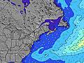 | 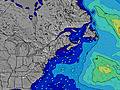 | 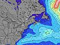 | 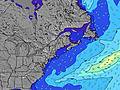 | 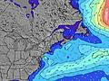 | 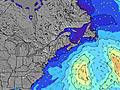 | 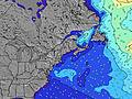 | 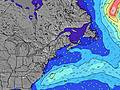 | 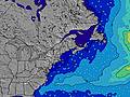 | ||||||||||||||
Swell Altura (m) Direção Período (s) | S 5 | S 5 | S 5 | SSE 4 | SSE 5 | SSE 6 | SSE 6 | SSE 6 | SSE 5 | SSE 5 | SSE 5 | SSE 6 | SSE 7 | S 8 | SSE 8 | SSE 8 | SSE 8 | SSE 8 | SSE 8 | SSE 8 | SSE 8 | SSE 8 | SSE 5 |
Onda Gráfico | |||||||||||||||||||||||
33 | 27 | 25 | 43 | 67 | 130 | 131 | 65 | 28 | 26 | 41 | 69 | 330 | 504 | 298 | 243 | 172 | 113 | 92 | 71 | 71 | 66 | 21 | |
Vento (km/h) | |||||||||||||||||||||||
Estado do Vento maral cruzado-maral Cruzado cruzado-terral terral cristalino | cross-on | cross | cross-on | cross-on | cross-on | cross-on | cross-on | cross-on | on | cross-on | cross-on | cross-on | cross | cross-off | cross-off | cross-off | cross-off | cross-off | cross-off | cross-off | cross-off | cross-off | glassy |
Maré Alta | 2:18PM2.80m | 2:31AM2.86m | 2:57PM2.87m | 3:15AM2.79m | 3:40PM2.92m | ||||||||||||||||||
Maré Baixa | 8:04AM0.03m | 8:21PM0.18m | 8:42AM0.05m | 9:05PM0.14m | 9:23AM0.10m | 9:55PM0.12m | |||||||||||||||||
5:30 | — | — | — | — | — | — | — | 5:31 | — | — | — | — | — | — | — | 5:31 | — | — | — | — | — | — | |
— | — | — | — | — | 8:01 | — | — | — | — | — | — | — | 8:00 | — | — | — | — | — | — | — | 8:00 | — | |
mm | 1 | — | — | — | — | — | — | — | — | 2 | 1 | 8 | 9 | 1 | — | — | — | — | — | — | — | — | — |
Temp. °C | 21 | 21 | 24 | 23 | 24 | 23 | 22 | 21 | 20 | 20 | 21 | 21 | 22 | 22 | 19 | 18 | 18 | 19 | 26 | 29 | 30 | 29 | 25 |
Ressent. °C | 22 | 21 | 24 | 21 | 22 | 21 | 21 | 22 | 21 | 21 | 20 | 20 | 21 | 20 | 15 | 15 | 14 | 15 | 23 | 26 | 26 | 27 | 24 |
Swell 1 Altura (m) Direção Período (s) | SSE 5 | SE 7 | SE 7 | ESE 9 | ESE 9 | SE 10 | ESE 9 | SE 9 | SE 7 | SE 6 | SE 9 | — | — | SSE 8 | SSE 8 | SSE 8 | SSE 8 | SSE 8 | SSE 8 | SSE 8 | SSE 8 | SSE 8 | SSE 5 |
27 | 8 | 13 | 8 | 8 | 4 | 8 | 3 | 12 | 11 | 3 | — | — | 395 | 298 | 243 | 172 | 113 | 92 | 71 | 71 | 66 | 21 | |
Swell 2 Altura (m) Direção Período (s) | SE 7 | SE 9 | ESE 9 | — | — | — | — | SSE 9 | SE 9 | SE 9 | — | — | — | — | — | — | — | — | — | — | — | SSE 8 | SSE 7 |
8 | 3 | 8 | — | — | — | — | 8 | 3 | 3 | — | — | — | — | — | — | — | — | — | — | — | 35 | 20 | |
Swell 3 Altura (m) Direção Período (s) | SSE 9 | S 8 | SE 9 | — | — | — | — | S 7 | S 7 | S 7 | — | — | — | — | — | — | — | — | — | — | — | — | E 10 |
8 | 5 | 3 | — | — | — | — | 1 | 1 | 3 | — | — | — | — | — | — | — | — | — | — | — | — | 2 | |
Ondas de vento Altura (m) Direção Período (s) | S 5 | S 5 | S 5 | SSE 4 | SSE 5 | SSE 6 | SSE 6 | SSE 6 | SSE 5 | SSE 5 | SSE 5 | SSE 6 | SSE 7 | S 8 | W 3 | — | WSW 2 | WSW 3 | WSW 3 | SW 3 | WSW 3 | W 3 | — |
33 | 27 | 25 | 43 | 67 | 130 | 131 | 65 | 28 | 26 | 41 | 69 | 330 | 504 | 5 | — | 1 | 2 | 1 | 2 | 1 | 1 | — | |
Terral ou glassy mais perto | |||||||||||||||||||||||
Distância (km) | 434 | 553 | 1967 | 1967 | 1967 | 1824 | 1299 | 1299 | 1824 | 1352 | 465 | 465 | 467 | 79 | 28 | 79 | 79 | 82 | 46 | 28 | 46 | 46 | 262 |
Melhor previsões de ondas em Maine | |||||||||||||||||||||||
Melhor previsões de ondas em United States | |||||||||||||||||||||||
Buscador de Ondas Global | |||||||||||||||||||||||
- Map Icons:
 Break
Break Live Wave Height (m)
 Live Wind Speed (km/h)
 Surf Rating (10 Max)
 Ocean Swells (m)
- Wind Speed (km/h)
widget de graça do Surf-Forecast.com para o seu site
O relatório de surf / widget do tempo abaixo está disponível para incorporar em sites de terceiros gratuitamente e fornece um resumo das nossas Two Lights surf tempo. Simplesmente pegar o trecho de código html que fornecemos e colá-lo em seu próprio site. Você pode escolher seu idioma preferido e unidades métrico/imperial para o surf tempo de alimentação para atender aos usuários do seu site.... Clique aqui para adquirir o código.
 Nearest