
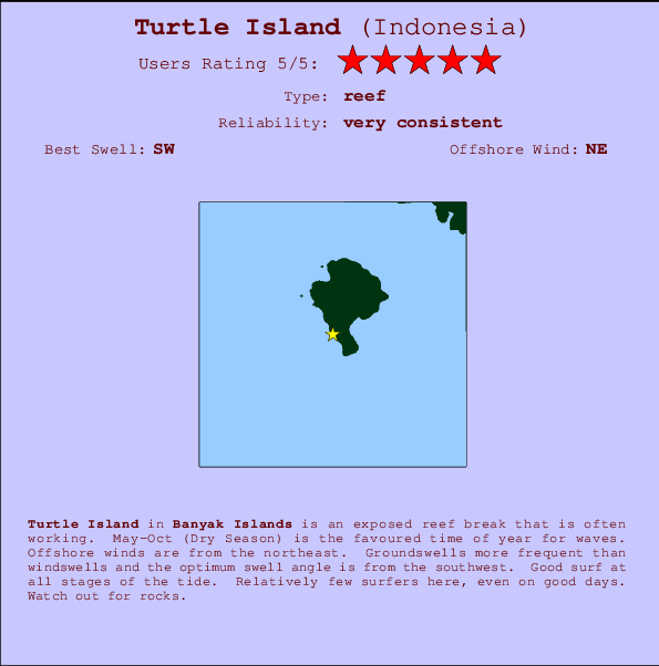
Turtle Island Surf Guide
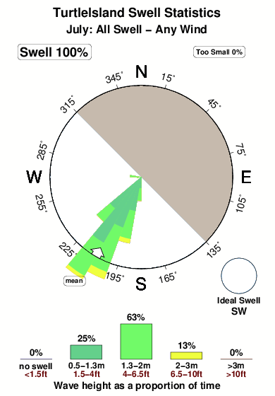
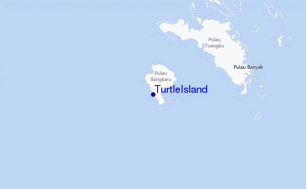
TurtleIsland in Banyak Islands is an exposed reef break that has very consistent waves. May-Oct (Dry Season) is the optimum time of year for waves. Offshore winds blow from the northeast. Clean groundswells prevail and the ideal swell direction is from the southwest. A reef breaks left. Good surf at all stages of the tide. Rarely crowded here. Watch out for rocks.
Turtle Island Spot Info
| Type: | Rating: | Reliability: | Todays Sea Temp*: |
|---|---|---|---|
| very consistent | 30.0°C*ocean temperature recorded from satellite |
Surfing Turtle Island:
The best conditions reported for surf at Turtle Island occur when a Southwest swell combines with an offshore wind direction from the Northeast.

Previsão da Energia de Ondas (Força): 12hrs


Turtle Island Surf:
Friday, 17 July 2026, 00:14 Local time| Quin | Sexta-feira 17 | |||
| 10PM | 1AM | 4AM | 7AM | |
| Wave (m) | ||||
| Período (s) | 15 | 15 | 15 | 15 |
| Vento (km/h) | ||||
| Estado do Vento | on | cross- on |
cross | glass |
- /breaks/Turtle-Island/forecasts/latest
Turtle Island Surf Guide
TurtleIsland in Banyak Islands is an exposed reef break that has very consistent waves. May-Oct (Dry Season) is the optimum time of year for waves. Offshore winds blow from the northeast. Clean groundswells prevail and the ideal swell direction is from the southwest. A reef breaks left. Good surf at all stages of the tide. Rarely crowded here. Watch out for rocks.
Turtle Island Spot Info
Type: Rating: Reliability: Todays Sea Temp*:  Reef
Reef 5
5very consistent 30.0°C*ocean temperature recorded from satelliteSurfing Turtle Island:
The best conditions reported for surf at Turtle Island occur when a Southwest swell combines with an offshore wind direction from the Northeast.
Previsão da Energia de Ondas (Força): 12hrs
Use a aba navegação acima para ver temperatura do mar em Turtle Island, fotografias de Turtle Island, previsões detalhadas do swell em Turtle Island, previsões do vento e do tempo, webcams em Turtle Island , vento atual em Banyak Islands com base em dados ao vivo fornecidos por estações de meteorologia e previsões da maré em Turtle Island. O link para os mapas do swell em Indonesia abrirá uma imagem ampliada monstrando Indonesia e os mares próximos. Estes mapas do swell podem ser animados para mostrar diferentes componentes do swell, energia das ondas, período das ondas, altura das ondas, assim como previsões do vento e do tempo, observações em tempo real do estado do tempo e do mar graças às bóias de Indonesia, navios passantes e estações de meteorologia presentes na costa. Cada uma das páginas de previsão para este surf break apresenta as ferramentas do buscador global e regional para localizar as melores condições de surf na área ao redor de Turtle Island.
Turtle Island Surf:
Friday, 17 July 2026, 00:14 Local timeQuin Sexta-feira 17 10PM 1AM 4AM 7AM Wave (m) Período (s) 15 15 15 15 Vento (km/h) Estado do Vento on cross-
oncross glass - /breaks/Turtle-Island/forecasts/latest
- /breaks/Turtle-Island/forecasts/latest/six_day
Turtle Island Surf Guide
TurtleIsland in Banyak Islands is an exposed reef break that has very consistent waves. May-Oct (Dry Season) is the optimum time of year for waves. Offshore winds blow from the northeast. Clean groundswells prevail and the ideal swell direction is from the southwest. A reef breaks left. Good surf at all stages of the tide. Rarely crowded here. Watch out for rocks.
Turtle Island Spot Info
Type: Rating: Reliability: Todays Sea Temp*: Reef5very consistent 30.0°C*ocean temperature recorded from satelliteSurfing Turtle Island:
The best conditions reported for surf at Turtle Island occur when a Southwest swell combines with an offshore wind direction from the Northeast.
Previsão da Energia de Ondas (Força): 12hrs
Use a aba navegação acima para ver temperatura do mar em Turtle Island, fotografias de Turtle Island, previsões detalhadas do swell em Turtle Island, previsões do vento e do tempo, webcams em Turtle Island , vento atual em Banyak Islands com base em dados ao vivo fornecidos por estações de meteorologia e previsões da maré em Turtle Island. O link para os mapas do swell em Indonesia abrirá uma imagem ampliada monstrando Indonesia e os mares próximos. Estes mapas do swell podem ser animados para mostrar diferentes componentes do swell, energia das ondas, período das ondas, altura das ondas, assim como previsões do vento e do tempo, observações em tempo real do estado do tempo e do mar graças às bóias de Indonesia, navios passantes e estações de meteorologia presentes na costa. Cada uma das páginas de previsão para este surf break apresenta as ferramentas do buscador global e regional para localizar as melores condições de surf na área ao redor de Turtle Island.
Turtle Island Surf:
Friday, 17 July 2026, 00:14 Local timeQuin Sexta-feira 17 10PM 1AM 4AM 7AM Wave (m) Período (s) 15 15 15 15 Vento (km/h) Estado do Vento on cross-
oncross glass - /breaks/Turtle-Island/forecasts/latest
Turtle Island Surf Guide
TurtleIsland in Banyak Islands is an exposed reef break that has very consistent waves. May-Oct (Dry Season) is the optimum time of year for waves. Offshore winds blow from the northeast. Clean groundswells prevail and the ideal swell direction is from the southwest. A reef breaks left. Good surf at all stages of the tide. Rarely crowded here. Watch out for rocks.
Turtle Island Spot Info
Type: Rating: Reliability: Todays Sea Temp*: Reef5very consistent 30.0°C*ocean temperature recorded from satelliteSurfing Turtle Island:
The best conditions reported for surf at Turtle Island occur when a Southwest swell combines with an offshore wind direction from the Northeast.
Previsão da Energia de Ondas (Força): 12hrs
Use a aba navegação acima para ver temperatura do mar em Turtle Island, fotografias de Turtle Island, previsões detalhadas do swell em Turtle Island, previsões do vento e do tempo, webcams em Turtle Island , vento atual em Banyak Islands com base em dados ao vivo fornecidos por estações de meteorologia e previsões da maré em Turtle Island. O link para os mapas do swell em Indonesia abrirá uma imagem ampliada monstrando Indonesia e os mares próximos. Estes mapas do swell podem ser animados para mostrar diferentes componentes do swell, energia das ondas, período das ondas, altura das ondas, assim como previsões do vento e do tempo, observações em tempo real do estado do tempo e do mar graças às bóias de Indonesia, navios passantes e estações de meteorologia presentes na costa. Cada uma das páginas de previsão para este surf break apresenta as ferramentas do buscador global e regional para localizar as melores condições de surf na área ao redor de Turtle Island.
Turtle Island Surf:
Friday, 17 July 2026, 00:14 Local timeQuin Sexta-feira 17 10PM 1AM 4AM 7AM Wave (m) Período (s) 15 15 15 15 Vento (km/h) Estado do Vento on cross-
oncross glass Tide Times:
Em Turtle Island (0 km).
A PRÓXIMA É ÀS (hora local) faltam maré alta maré baixa Turtle Island Tide Times and Tide Chart
Live Weather:
At ASCATB97E2N, 32 km from Turtle Island.
light winds from the NW
(km/h)Air temperature
-°COverall Turtle Island Surf Consistency and Wind Distribution in Julho
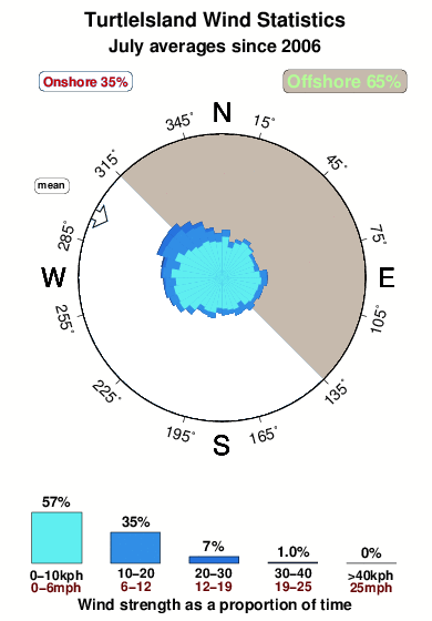


Wind stats for Turtle Island: see the variation in direction and stength by month.
fotos da galeria
Contornos: Estradas & Rios: Escolha um spot de surf da lista 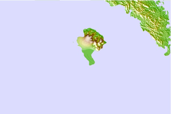
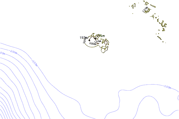

Use este mapa de relevo para navegar até Banyak Islands surf quebras e estações que estão na área de maré Turtle Island
Outros Spots de Surf mais próximos de Turtle Island:
(Clique no nome do local para maiores detalhes)- Closest spot17 mi
- Second closest spot19 mi
- Third closest spot21 mi
- Fourth closest spot58 mi
- Fifth closest spot58 mi
Bóias ondográficas mais próxima de Turtle Island:
- Closest bóia ondográfica2374 mi
- Second closest bóia ondográfica2452 mi
- Third closest bóia ondográfica2631 mi
- Fourth closest bóia ondográfica2647 mi
- Fifth closest bóia ondográfica2812 mi
Estações de maré mais próximo de Turtle Island:
- Closest estação de maréSinabang58 mi
- Second closest estação de maréSibolga118 mi
- Third closest estação de maréMeulaboh160 mi
- Fourth closest estação de maréPangkalan Brandan160 mi
- Fifth closest estação de maréTanjungtiram165 mi
Airports
- The nearest passenger airport to TurtleIsland is Binaka (Gunung Sitoli) Airport (GNS) in Indonesia, which is 118 km (73 miles) away (directly).
- The second closest airport to TurtleIsland is Polonia (Medan) Airport (MES), also in Indonesia, 244 km (152 miles) away.
- /breaks/Turtle-Island/forecasts/latest
 Nearest