
Trearddur Bay (Holy Island) Surf Guide
Trearddur Bay(Holy Island) in Anglesy is a quite exposed beach break that has unreliable waves with no particular seasonal pattern. Works best in offshore winds from the northeast with some shelter here from southeast winds. Windswells and groundswells in equal measure and the ideal swell angle is from the southwest. The beach breaks offer lefts and rights. When the surf is up, it can get quite busy in the water. Hazards include rips and rocks.
Trearddur Bay (Holy Island) Spot Info
| Type: | Rating: | Reliability: | Todays Sea Temp*: |
|---|---|---|---|
| inconsistent | 16.8°C*ocean temperature recorded from satellite |
Surfing Trearddur Bay (Holy Island):
The best conditions reported for surf at Trearddur Bay (Holy Island) occur when a Southwest swell combines with an offshore wind direction from the Northeast.
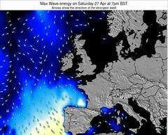
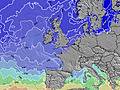
Previsão da Energia de Ondas (Força): 12hrs


Trearddur Bay (Holy Island) Surf:
Monday, 27 July 2026, 14:38 Local time| Segunda-feira 27 | ||||
| 10AM | 1PM | 4PM | 7PM | |
| Wave (m) | ||||
| Período (s) | 4 | 4 | 4 | 4 |
| Vento (km/h) | ||||
| Estado do Vento | on | on | on | on |
- /breaks/Trearddur-Bay_Holy-Island/forecasts/latest
Trearddur Bay (Holy Island) Surf Guide
Trearddur Bay(Holy Island) in Anglesy is a quite exposed beach break that has unreliable waves with no particular seasonal pattern. Works best in offshore winds from the northeast with some shelter here from southeast winds. Windswells and groundswells in equal measure and the ideal swell angle is from the southwest. The beach breaks offer lefts and rights. When the surf is up, it can get quite busy in the water. Hazards include rips and rocks.
Trearddur Bay (Holy Island) Spot Info
Type: Rating: Reliability: Todays Sea Temp*:  Beach
Beach 2
2inconsistent 16.8°C*ocean temperature recorded from satelliteSurfing Trearddur Bay (Holy Island):
The best conditions reported for surf at Trearddur Bay (Holy Island) occur when a Southwest swell combines with an offshore wind direction from the Northeast.
Previsão da Energia de Ondas (Força): 12hrs
Use a aba navegação acima para ver temperatura do mar em Trearddur Bay (Holy Island), fotografias de Trearddur Bay (Holy Island), previsões detalhadas do swell em Trearddur Bay (Holy Island), previsões do vento e do tempo, webcams em Trearddur Bay (Holy Island) , vento atual em Wales - Anglesy com base em dados ao vivo fornecidos por estações de meteorologia e previsões da maré em Trearddur Bay (Holy Island). O link para os mapas do swell em United Kingdom abrirá uma imagem ampliada monstrando United Kingdom e os mares próximos. Estes mapas do swell podem ser animados para mostrar diferentes componentes do swell, energia das ondas, período das ondas, altura das ondas, assim como previsões do vento e do tempo, observações em tempo real do estado do tempo e do mar graças às bóias de United Kingdom, navios passantes e estações de meteorologia presentes na costa. Cada uma das páginas de previsão para este surf break apresenta as ferramentas do buscador global e regional para localizar as melores condições de surf na área ao redor de Trearddur Bay (Holy Island).
Trearddur Bay (Holy Island) Surf:
Monday, 27 July 2026, 14:38 Local timeSegunda-feira 27 10AM 1PM 4PM 7PM Wave (m) Período (s) 4 4 4 4 Vento (km/h) Estado do Vento on on on on - /breaks/Trearddur-Bay_Holy-Island/forecasts/latest
- /breaks/Trearddur-Bay_Holy-Island/forecasts/latest/six_day
Trearddur Bay (Holy Island) Surf Guide
Trearddur Bay(Holy Island) in Anglesy is a quite exposed beach break that has unreliable waves with no particular seasonal pattern. Works best in offshore winds from the northeast with some shelter here from southeast winds. Windswells and groundswells in equal measure and the ideal swell angle is from the southwest. The beach breaks offer lefts and rights. When the surf is up, it can get quite busy in the water. Hazards include rips and rocks.
Trearddur Bay (Holy Island) Spot Info
Type: Rating: Reliability: Todays Sea Temp*: Beach2inconsistent 16.8°C*ocean temperature recorded from satelliteSurfing Trearddur Bay (Holy Island):
The best conditions reported for surf at Trearddur Bay (Holy Island) occur when a Southwest swell combines with an offshore wind direction from the Northeast.
Previsão da Energia de Ondas (Força): 12hrs
Use a aba navegação acima para ver temperatura do mar em Trearddur Bay (Holy Island), fotografias de Trearddur Bay (Holy Island), previsões detalhadas do swell em Trearddur Bay (Holy Island), previsões do vento e do tempo, webcams em Trearddur Bay (Holy Island) , vento atual em Wales - Anglesy com base em dados ao vivo fornecidos por estações de meteorologia e previsões da maré em Trearddur Bay (Holy Island). O link para os mapas do swell em United Kingdom abrirá uma imagem ampliada monstrando United Kingdom e os mares próximos. Estes mapas do swell podem ser animados para mostrar diferentes componentes do swell, energia das ondas, período das ondas, altura das ondas, assim como previsões do vento e do tempo, observações em tempo real do estado do tempo e do mar graças às bóias de United Kingdom, navios passantes e estações de meteorologia presentes na costa. Cada uma das páginas de previsão para este surf break apresenta as ferramentas do buscador global e regional para localizar as melores condições de surf na área ao redor de Trearddur Bay (Holy Island).
Trearddur Bay (Holy Island) Surf:
Monday, 27 July 2026, 14:38 Local timeSegunda-feira 27 10AM 1PM 4PM 7PM Wave (m) Período (s) 4 4 4 4 Vento (km/h) Estado do Vento on on on on - /breaks/Trearddur-Bay_Holy-Island/forecasts/latest
Trearddur Bay (Holy Island) Surf Guide
Trearddur Bay(Holy Island) in Anglesy is a quite exposed beach break that has unreliable waves with no particular seasonal pattern. Works best in offshore winds from the northeast with some shelter here from southeast winds. Windswells and groundswells in equal measure and the ideal swell angle is from the southwest. The beach breaks offer lefts and rights. When the surf is up, it can get quite busy in the water. Hazards include rips and rocks.
Trearddur Bay (Holy Island) Spot Info
Type: Rating: Reliability: Todays Sea Temp*: Beach2inconsistent 16.8°C*ocean temperature recorded from satelliteSurfing Trearddur Bay (Holy Island):
The best conditions reported for surf at Trearddur Bay (Holy Island) occur when a Southwest swell combines with an offshore wind direction from the Northeast.
Previsão da Energia de Ondas (Força): 12hrs
Use a aba navegação acima para ver temperatura do mar em Trearddur Bay (Holy Island), fotografias de Trearddur Bay (Holy Island), previsões detalhadas do swell em Trearddur Bay (Holy Island), previsões do vento e do tempo, webcams em Trearddur Bay (Holy Island) , vento atual em Wales - Anglesy com base em dados ao vivo fornecidos por estações de meteorologia e previsões da maré em Trearddur Bay (Holy Island). O link para os mapas do swell em United Kingdom abrirá uma imagem ampliada monstrando United Kingdom e os mares próximos. Estes mapas do swell podem ser animados para mostrar diferentes componentes do swell, energia das ondas, período das ondas, altura das ondas, assim como previsões do vento e do tempo, observações em tempo real do estado do tempo e do mar graças às bóias de United Kingdom, navios passantes e estações de meteorologia presentes na costa. Cada uma das páginas de previsão para este surf break apresenta as ferramentas do buscador global e regional para localizar as melores condições de surf na área ao redor de Trearddur Bay (Holy Island).
Trearddur Bay (Holy Island) Surf:
Monday, 27 July 2026, 14:38 Local timeSegunda-feira 27 10AM 1PM 4PM 7PM Wave (m) Período (s) 4 4 4 4 Vento (km/h) Estado do Vento on on on on Tide Times:
Para Holyhead, Wales %{dist} %{km} de %{location}
A PRÓXIMA É ÀS (hora local) faltam maré alta maré baixa Trearddur Bay (Holy Island) Tide Times and Tide Chart
Live Weather:
At Valley RAF Airport, 8 km from Trearddur Bay (Holy Island).
fresh winds from the SSW
(km/h)
Dry and partly cloudyAir temperature
17°COverall Trearddur Bay (Holy Island) Surf Consistency and Wind Distribution in Julho


Wind stats for Trearddur Bay (Holy Island): see the variation in direction and stength by month.
fotos da galeria
Contornos: Estradas & Rios: Escolha um spot de surf da lista 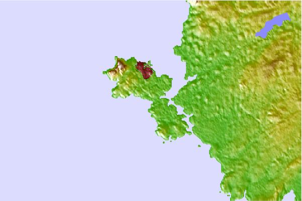
Use este mapa de relevo para navegar até Wales - Anglesy surf quebras e estações que estão na área de maré Trearddur Bay (Holy Island)
Outros Spots de Surf mais próximos de Trearddur Bay (Holy Island):
(Clique no nome do local para maiores detalhes)- Closest spot1 mi
- Second closest spot5 mi
- Third closest spot5 mi
- Fourth closest spot6 mi
- Fifth closest spot7 mi
Bóias ondográficas mais próxima de Trearddur Bay (Holy Island):
- Closest bóia ondográfica35 mi
- Second closest bóia ondográfica35 mi
- Third closest bóia ondográfica55 mi
- Fourth closest bóia ondográfica55 mi
- Fifth closest bóia ondográfica58 mi
Estações de maré mais próximo de Trearddur Bay (Holy Island):
- Closest estação de maréHolyhead2 mi
- Second closest estação de maréCaernarfon17 mi
- Third closest estação de maréBangor21 mi
- Fourth closest estação de maréLlandudno, Gwynedd33 mi
- Fifth closest estação de maréDeganwy33 mi
Airports
- The closest passenger airport to Trearddur Bay (Holy Island) is Isle Of Man Airport (IOM) in England, 90 km (56 miles) away (directly).
- The second nearest airport to Trearddur Bay (Holy Island) is Hawarden Airport (CEG), also in England, 110 km (68 miles) away.
- Third is Dublin Airport (DUB) in Ireland, 110 km (68 miles) away.
- Liverpool Airport (LPL) in England is 118 km (73 miles) away.
- Blackpool Airport (BLK), also in England is the fifth nearest airport to Trearddur Bay (Holy Island) and is 119 km (74 miles) away.

- /breaks/Trearddur-Bay_Holy-Island/forecasts/latest
 Nearest