
Previsão:

Previsão de curto prazoprincipalmente seco. Warm (máx. 22°C na Sexta de manhã, mín 18°C na Sexta de noite). o vento será geralmente fraco. | |||||||||||||||||||||
Sex 17 | Sábado 18 | Domingo 19 | |||||||||||||||||||
10 AM | 1 PM | 4 PM | 7 PM | 10 PM | 1 AM | 4 AM | 7 AM | 10 AM | 1 PM | 4 PM | 7 PM | 10 PM | 1 AM | 4 AM | 7 AM | 10 AM | 1 PM | 4 PM | 7 PM | 10 PM | |
Mapa da altura do Swell |  |  |  | 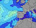 |  |  | 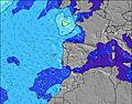 |  | |||||||||||||
Swell Altura (m) Direção Período (s) | WNW 8 | WNW 8 | S 15 | S 14 | WNW 8 | WNW 8 | WNW 8 | WNW 8 | WNW 8 | WNW 8 | S 19 | S 19 | S 19 | S 19 | WNW 8 | S 18 | W 10 | W 9 | SW 18 | SW 18 | WNW 8 |
Onda Gráfico | |||||||||||||||||||||
13 | 13 | 4 | 4 | 13 | 13 | 12 | 13 | 13 | 13 | 7 | 7 | 7 | 7 | 6 | 6 | 7 | 12 | 12 | 12 | 14 | |
Vento (km/h) | |||||||||||||||||||||
Estado do Vento maral cruzado-maral Cruzado cruzado-terral terral cristalino | off | off | off | off | off | off | off | off | off | off | off | off | off | off | off | off | off | cross-off | cross-off | off | off |
Maré Alta | 5:40PM3.05m | 6:09AM2.62m | 6:26PM2.88m | 6:54AM2.49m | 7:11PM2.67m | ||||||||||||||||
Maré Baixa | 11:21AM0.15m | 11:59PM0.08m | 12:05PM0.27m | 00:43AM0.24m | 12:50PM0.42m | ||||||||||||||||
6:24 | — | — | — | — | — | 6:26 | — | — | — | — | — | — | — | 6:26 | — | — | — | — | — | — | |
— | — | — | 9:00 | — | — | — | — | — | — | — | 8:59 | — | — | — | — | — | — | — | 8:59 | — | |
mm | — | — | — | — | — | — | — | — | — | — | — | — | — | — | — | — | — | — | — | — | — |
Temp. °C | 21 | 22 | 22 | 21 | 20 | 19 | 18 | 18 | 21 | 22 | 22 | 21 | 19 | 19 | 19 | 18 | 20 | 21 | 22 | 21 | 20 |
Ressent. °C | 20 | 20 | 19 | 18 | 18 | 18 | 17 | 18 | 20 | 20 | 19 | 18 | 17 | 17 | 18 | 17 | 19 | 19 | 20 | 19 | 19 |
Swell 1 Altura (m) Direção Período (s) | WNW 8 | WNW 8 | SW 6 | SW 5 | WNW 8 | WNW 8 | WNW 8 | WNW 8 | WNW 8 | WNW 8 | S 19 | S 19 | WNW 8 | WNW 8 | WNW 8 | WNW 8 | WNW 8 | W 9 | SW 18 | SW 18 | WNW 8 |
13 | 13 | 1 | 1 | 13 | 13 | 12 | 13 | 13 | 13 | 7 | 7 | 6 | 6 | 6 | 6 | 6 | 7 | 12 | 12 | 14 | |
Swell 2 Altura (m) Direção Período (s) | W 6 | SW 6 | S 15 | S 14 | WSW 6 | SW 6 | SW 5 | SW 5 | — | — | S 13 | S 13 | S 19 | W 11 | W 10 | W 10 | W 10 | SW 18 | NW 9 | S 11 | NW 8 |
1 | 1 | 4 | 4 | 3 | 1 | 1 | 1 | — | — | 3 | 3 | 7 | 2 | 2 | 2 | 7 | 12 | 3 | 2 | 2 | |
Swell 3 Altura (m) Direção Período (s) | S 12 | S 15 | S 10 | — | S 14 | S 14 | S 14 | S 13 | S 13 | S 19 | — | W 11 | W 11 | S 19 | NW 8 | S 18 | S 18 | NW 10 | S 11 | — | NW 9 |
3 | 4 | 2 | — | 4 | 4 | 4 | 4 | 3 | 7 | — | 2 | 2 | 7 | 3 | 6 | 6 | 4 | 3 | — | 3 | |
Ondas de vento Altura (m) Direção Período (s) | WNW 5 | WNW 3 | WNW 4 | WNW 4 | NW 4 | NW 4 | NW 4 | NW 4 | NW 4 | NW 4 | WNW 4 | NW 4 | NW 4 | NW 4 | NW 5 | NW 5 | NW 5 | NW 7 | WNW 4 | WNW 4 | NW 4 |
7 | 4 | 24 | 31 | 20 | 12 | 7 | 8 | 6 | 8 | 20 | 36 | 22 | 18 | 22 | 20 | 16 | 56 | 28 | 31 | 18 | |
Terral ou glassy mais perto | |||||||||||||||||||||
Distância (km) | 902 | 1350 | 1350 | 902 | 902 | 873 | 356 | 139 | 506 | 1332 | 968 | 902 | 302 | 227 | 188 | 222 | 302 | 579 | 439 | 347 | 222 |
Melhor previsões de ondas em Lisboa | |||||||||||||||||||||
Melhor previsões de ondas em Portugal | |||||||||||||||||||||
Buscador de Ondas Global | |||||||||||||||||||||
- Map Icons:
 Break
Break Live Wave Height (m)
 Live Wind Speed (km/h)
 Surf Rating (10 Max)
 Ocean Swells (m)
- Wind Speed (km/h)
widget de graça do Surf-Forecast.com para o seu site
O relatório de surf / widget do tempo abaixo está disponível para incorporar em sites de terceiros gratuitamente e fornece um resumo das nossas Torre surf tempo. Simplesmente pegar o trecho de código html que fornecemos e colá-lo em seu próprio site. Você pode escolher seu idioma preferido e unidades métrico/imperial para o surf tempo de alimentação para atender aos usuários do seu site.... Clique aqui para adquirir o código.
 Nearest