

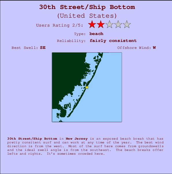
30th Street/Ship Bottom Surf Guide
30th Street/Ship Bottom in New Jersey is an exposed beach break that has fairly consistent surf and can work at any time of the year. Offshore winds are from the west. Most of the surf here comes from groundswells and the best swell direction is from the southeast. Waves at the beach break both left and right. When it's working here, it can get crowded.
30th Street/Ship Bottom Spot Info
| Type: | Rating: | Reliability: | Todays Sea Temp*: |
|---|---|---|---|
| fairly consistent | 25.0°C*ocean temperature recorded from satellite |
Surfing 30th Street/Ship Bottom:
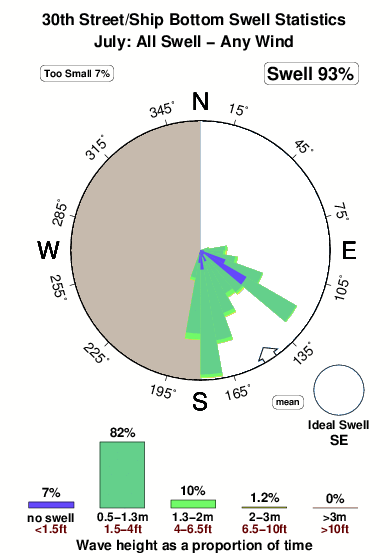
The best conditions reported for surf at 30th Street/Ship Bottom occur when a Southeast swell combines with an offshore wind direction from the West.

Previsão da Energia de Ondas (Força): 12hrs


30th Street/Ship Bottom Surf:
Saturday, 18 July 2026, 07:17 Local time| Sábado 18 | ||||
| 5AM | 8AM | 11AM | 2PM | |
| Wave (m) | ||||
| Período (s) | 14 | 14 | 14 | 13 |
| Vento (km/h) | ||||
| Estado do Vento | cross- off |
cross- off |
cross- off |
cross |
- /breaks/Thirtith-Street/forecasts/latest
30th Street/Ship Bottom Surf Guide
30th Street/Ship Bottom in New Jersey is an exposed beach break that has fairly consistent surf and can work at any time of the year. Offshore winds are from the west. Most of the surf here comes from groundswells and the best swell direction is from the southeast. Waves at the beach break both left and right. When it's working here, it can get crowded.
30th Street/Ship Bottom Spot Info
Type: Rating: Reliability: Todays Sea Temp*:  Beach
Beach 2
2fairly consistent 25.0°C*ocean temperature recorded from satelliteSurfing 30th Street/Ship Bottom:
The best conditions reported for surf at 30th Street/Ship Bottom occur when a Southeast swell combines with an offshore wind direction from the West.
Previsão da Energia de Ondas (Força): 12hrs
Use a aba navegação acima para ver temperatura do mar em 30th Street/Ship Bottom, fotografias de 30th Street/Ship Bottom, previsões detalhadas do swell em 30th Street/Ship Bottom, previsões do vento e do tempo, webcams em 30th Street/Ship Bottom , vento atual em New Jersey com base em dados ao vivo fornecidos por estações de meteorologia e previsões da maré em 30th Street/Ship Bottom. O link para os mapas do swell em United States abrirá uma imagem ampliada monstrando United States e os mares próximos. Estes mapas do swell podem ser animados para mostrar diferentes componentes do swell, energia das ondas, período das ondas, altura das ondas, assim como previsões do vento e do tempo, observações em tempo real do estado do tempo e do mar graças às bóias de United States, navios passantes e estações de meteorologia presentes na costa. Cada uma das páginas de previsão para este surf break apresenta as ferramentas do buscador global e regional para localizar as melores condições de surf na área ao redor de 30th Street/Ship Bottom.
30th Street/Ship Bottom Surf:
Saturday, 18 July 2026, 07:17 Local timeSábado 18 5AM 8AM 11AM 2PM Wave (m) Período (s) 14 14 14 13 Vento (km/h) Estado do Vento cross-
offcross-
offcross-
offcross - /breaks/Thirtith-Street/forecasts/latest
- /breaks/Thirtith-Street/forecasts/latest/six_day
30th Street/Ship Bottom Surf Guide
30th Street/Ship Bottom in New Jersey is an exposed beach break that has fairly consistent surf and can work at any time of the year. Offshore winds are from the west. Most of the surf here comes from groundswells and the best swell direction is from the southeast. Waves at the beach break both left and right. When it's working here, it can get crowded.
30th Street/Ship Bottom Spot Info
Type: Rating: Reliability: Todays Sea Temp*: Beach2fairly consistent 25.0°C*ocean temperature recorded from satelliteSurfing 30th Street/Ship Bottom:
The best conditions reported for surf at 30th Street/Ship Bottom occur when a Southeast swell combines with an offshore wind direction from the West.
Previsão da Energia de Ondas (Força): 12hrs
Use a aba navegação acima para ver temperatura do mar em 30th Street/Ship Bottom, fotografias de 30th Street/Ship Bottom, previsões detalhadas do swell em 30th Street/Ship Bottom, previsões do vento e do tempo, webcams em 30th Street/Ship Bottom , vento atual em New Jersey com base em dados ao vivo fornecidos por estações de meteorologia e previsões da maré em 30th Street/Ship Bottom. O link para os mapas do swell em United States abrirá uma imagem ampliada monstrando United States e os mares próximos. Estes mapas do swell podem ser animados para mostrar diferentes componentes do swell, energia das ondas, período das ondas, altura das ondas, assim como previsões do vento e do tempo, observações em tempo real do estado do tempo e do mar graças às bóias de United States, navios passantes e estações de meteorologia presentes na costa. Cada uma das páginas de previsão para este surf break apresenta as ferramentas do buscador global e regional para localizar as melores condições de surf na área ao redor de 30th Street/Ship Bottom.
30th Street/Ship Bottom Surf:
Saturday, 18 July 2026, 07:17 Local timeSábado 18 5AM 8AM 11AM 2PM Wave (m) Período (s) 14 14 14 13 Vento (km/h) Estado do Vento cross-
offcross-
offcross-
offcross - /breaks/Thirtith-Street/forecasts/latest
30th Street/Ship Bottom Surf Guide
30th Street/Ship Bottom in New Jersey is an exposed beach break that has fairly consistent surf and can work at any time of the year. Offshore winds are from the west. Most of the surf here comes from groundswells and the best swell direction is from the southeast. Waves at the beach break both left and right. When it's working here, it can get crowded.
30th Street/Ship Bottom Spot Info
Type: Rating: Reliability: Todays Sea Temp*: Beach2fairly consistent 25.0°C*ocean temperature recorded from satelliteSurfing 30th Street/Ship Bottom:
The best conditions reported for surf at 30th Street/Ship Bottom occur when a Southeast swell combines with an offshore wind direction from the West.
Previsão da Energia de Ondas (Força): 12hrs
Use a aba navegação acima para ver temperatura do mar em 30th Street/Ship Bottom, fotografias de 30th Street/Ship Bottom, previsões detalhadas do swell em 30th Street/Ship Bottom, previsões do vento e do tempo, webcams em 30th Street/Ship Bottom , vento atual em New Jersey com base em dados ao vivo fornecidos por estações de meteorologia e previsões da maré em 30th Street/Ship Bottom. O link para os mapas do swell em United States abrirá uma imagem ampliada monstrando United States e os mares próximos. Estes mapas do swell podem ser animados para mostrar diferentes componentes do swell, energia das ondas, período das ondas, altura das ondas, assim como previsões do vento e do tempo, observações em tempo real do estado do tempo e do mar graças às bóias de United States, navios passantes e estações de meteorologia presentes na costa. Cada uma das páginas de previsão para este surf break apresenta as ferramentas do buscador global e regional para localizar as melores condições de surf na área ao redor de 30th Street/Ship Bottom.
30th Street/Ship Bottom Surf:
Saturday, 18 July 2026, 07:17 Local timeSábado 18 5AM 8AM 11AM 2PM Wave (m) Período (s) 14 14 14 13 Vento (km/h) Estado do Vento cross-
offcross-
offcross-
offcross Tide Times:
Para Seaside Heights, ocean, New Jersey %{dist} %{km} de %{location}
A PRÓXIMA É ÀS (hora local) faltam maré alta maré baixa 30th Street/Ship Bottom Tide Times and Tide Chart
Live Weather:
At BUOY-JCRN4, 26 km from 30th Street/Ship Bottom.
calm
(km/h)Air temperature
21.2°COverall 30th Street/Ship Bottom Surf Consistency and Wind Distribution in Julho
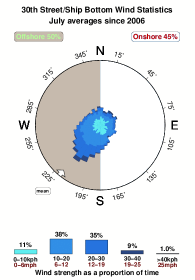


Wind stats for 30th Street/Ship Bottom: see the variation in direction and stength by month.
fotos da galeria
Contornos: Estradas & Rios: Escolha um spot de surf da lista 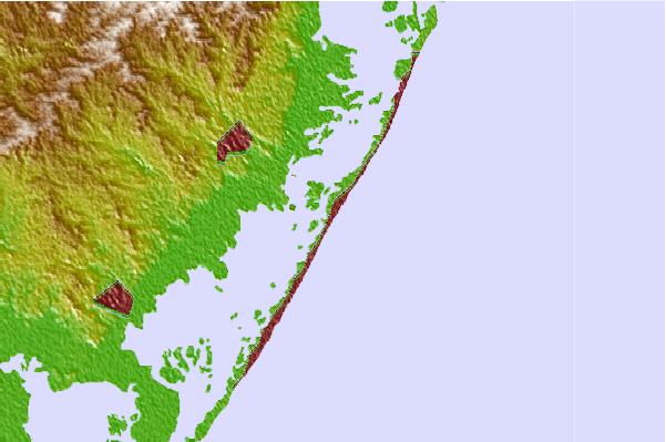

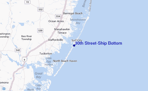
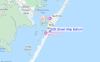
Use este mapa de relevo para navegar até New Jersey surf quebras e estações que estão na área de maré 30th Street/Ship Bottom
Outros Spots de Surf mais próximos de 30th Street/Ship Bottom:
(Clique no nome do local para maiores detalhes)- Closest spot1 mi
- Second closest spot2 mi
- Third closest spot2 mi
- Fourth closest spot4 mi
- Fifth closest spot4 mi
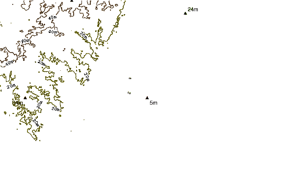
Bóias ondográficas mais próxima de 30th Street/Ship Bottom:
- Closest bóia ondográfica2 mi
- Second closest bóia ondográfica24 mi
- Third closest bóia ondográfica57 mi
- Fourth closest bóia ondográfica68 mi
- Fifth closest bóia ondográfica85 mi
Estações de maré mais próximo de 30th Street/Ship Bottom:
- Closest estação de maréManahawkin Drawbridge, Manahawkin Bay1 mi
- Second closest estação de maréBeach Haven Crest2 mi
- Third closest estação de maréManahawkin Creek, Manahawkin Bay2 mi
- Fourth closest estação de maréMill Creek, 1 nautical miles above entrance3 mi
- Fifth closest estação de maréNorth Beach, Manahawkin Bay3 mi
Airports
- The closest passenger airport to 30th Street/Ship Bottom is Atlantic City International Airport (ACY) in USA, 39 km (24 miles) away (directly).
- The second nearest airport to 30th Street/Ship Bottom is Lakehurst Naes Airport (NEL), also in USA, 46 km (29 miles) away.
- Third is Mc Guire Afb (Wrightstown) Airport (WRI) in USA, 55 km (34 miles) away.
- Millville Muni Airport (MIV) in USA is 82 km (51 miles) away.
- Northeast Philadelphia Airport (PNE), also in USA is the fifth nearest airport to 30th Street/Ship Bottom and is 86 km (53 miles) away.
- /breaks/Thirtith-Street/forecasts/latest
 Nearest