

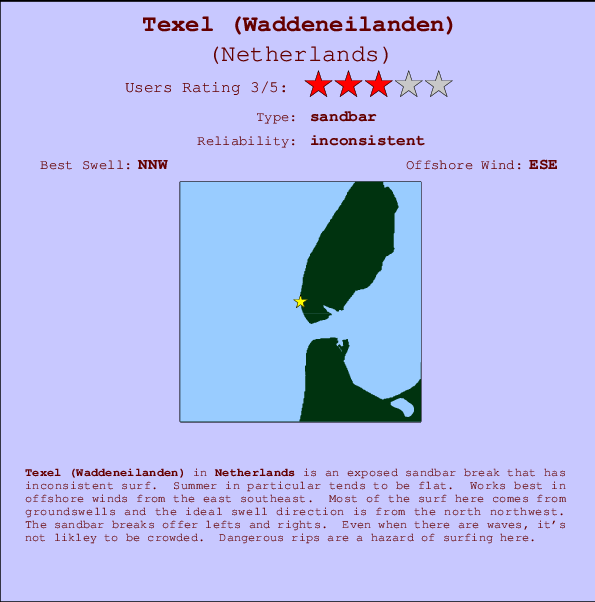
Texel (Waddeneilanden) Surf Guide
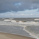
Texel (Waddeneilanden) on the West Coast is an exposed beach break that has inconsistent surf. Summer in particular tends to be flat. The best wind direction is from the east southeast. Tends to receive a mix of groundswells and windswells and the ideal swell direction is from the north northwest. The beach breaks offer lefts and rights. Rarely crowded here. Dangerous rips are a hazard of surfing here.
Texel (Waddeneilanden) Spot Info
| Type: | Rating: | Reliability: | Todays Sea Temp*: |
|---|---|---|---|
| inconsistent | 19.3°C*ocean temperature recorded from satellite |
Surfing Texel (Waddeneilanden):
The best conditions reported for surf at Texel (Waddeneilanden) occur when a North-northwest swell combines with an offshore wind direction from the East-southeast.
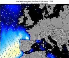
Previsão da Energia de Ondas (Força): 12hrs


Texel (Waddeneilanden) Surf:
Sunday, 26 July 2026, 08:49 Local time| Domingo 26 | ||||
| 5AM | 8AM | 11AM | 2PM | |
| Wave (m) | ||||
| Período (s) | 6 | 7 | 5 | 6 |
| Vento (km/h) | ||||
| Estado do Vento | cross- on |
cross- on |
cross- on |
cross- on |
- /breaks/Texel_Waddeneilanden/forecasts/latest
Texel (Waddeneilanden) Surf Guide
Texel (Waddeneilanden) on the West Coast is an exposed beach break that has inconsistent surf. Summer in particular tends to be flat. The best wind direction is from the east southeast. Tends to receive a mix of groundswells and windswells and the ideal swell direction is from the north northwest. The beach breaks offer lefts and rights. Rarely crowded here. Dangerous rips are a hazard of surfing here.
Texel (Waddeneilanden) Spot Info
Type: Rating: Reliability: Todays Sea Temp*:  Sandbar
 3
3inconsistent 19.3°C*ocean temperature recorded from satelliteSurfing Texel (Waddeneilanden):
The best conditions reported for surf at Texel (Waddeneilanden) occur when a North-northwest swell combines with an offshore wind direction from the East-southeast.
Previsão da Energia de Ondas (Força): 12hrs
Use a aba navegação acima para ver temperatura do mar em Texel (Waddeneilanden), fotografias de Texel (Waddeneilanden), previsões detalhadas do swell em Texel (Waddeneilanden), previsões do vento e do tempo, webcams em Texel (Waddeneilanden) , vento atual em Netherlands com base em dados ao vivo fornecidos por estações de meteorologia e previsões da maré em Texel (Waddeneilanden). O link para os mapas do swell em Netherlands abrirá uma imagem ampliada monstrando Netherlands e os mares próximos. Estes mapas do swell podem ser animados para mostrar diferentes componentes do swell, energia das ondas, período das ondas, altura das ondas, assim como previsões do vento e do tempo, observações em tempo real do estado do tempo e do mar graças às bóias de Netherlands, navios passantes e estações de meteorologia presentes na costa. Cada uma das páginas de previsão para este surf break apresenta as ferramentas do buscador global e regional para localizar as melores condições de surf na área ao redor de Texel (Waddeneilanden).
Texel (Waddeneilanden) Surf:
Sunday, 26 July 2026, 08:49 Local timeDomingo 26 5AM 8AM 11AM 2PM Wave (m) Período (s) 6 7 5 6 Vento (km/h) Estado do Vento cross-
oncross-
oncross-
oncross-
on- /breaks/Texel_Waddeneilanden/forecasts/latest
- /breaks/Texel_Waddeneilanden/forecasts/latest/six_day
Texel (Waddeneilanden) Surf Guide
Texel (Waddeneilanden) on the West Coast is an exposed beach break that has inconsistent surf. Summer in particular tends to be flat. The best wind direction is from the east southeast. Tends to receive a mix of groundswells and windswells and the ideal swell direction is from the north northwest. The beach breaks offer lefts and rights. Rarely crowded here. Dangerous rips are a hazard of surfing here.
Texel (Waddeneilanden) Spot Info
Type: Rating: Reliability: Todays Sea Temp*: Sandbar3inconsistent 19.3°C*ocean temperature recorded from satelliteSurfing Texel (Waddeneilanden):
The best conditions reported for surf at Texel (Waddeneilanden) occur when a North-northwest swell combines with an offshore wind direction from the East-southeast.
Previsão da Energia de Ondas (Força): 12hrs
Use a aba navegação acima para ver temperatura do mar em Texel (Waddeneilanden), fotografias de Texel (Waddeneilanden), previsões detalhadas do swell em Texel (Waddeneilanden), previsões do vento e do tempo, webcams em Texel (Waddeneilanden) , vento atual em Netherlands com base em dados ao vivo fornecidos por estações de meteorologia e previsões da maré em Texel (Waddeneilanden). O link para os mapas do swell em Netherlands abrirá uma imagem ampliada monstrando Netherlands e os mares próximos. Estes mapas do swell podem ser animados para mostrar diferentes componentes do swell, energia das ondas, período das ondas, altura das ondas, assim como previsões do vento e do tempo, observações em tempo real do estado do tempo e do mar graças às bóias de Netherlands, navios passantes e estações de meteorologia presentes na costa. Cada uma das páginas de previsão para este surf break apresenta as ferramentas do buscador global e regional para localizar as melores condições de surf na área ao redor de Texel (Waddeneilanden).
Texel (Waddeneilanden) Surf:
Sunday, 26 July 2026, 08:49 Local timeDomingo 26 5AM 8AM 11AM 2PM Wave (m) Período (s) 6 7 5 6 Vento (km/h) Estado do Vento cross-
oncross-
oncross-
oncross-
on- /breaks/Texel_Waddeneilanden/forecasts/latest
Texel (Waddeneilanden) Surf Guide
Texel (Waddeneilanden) on the West Coast is an exposed beach break that has inconsistent surf. Summer in particular tends to be flat. The best wind direction is from the east southeast. Tends to receive a mix of groundswells and windswells and the ideal swell direction is from the north northwest. The beach breaks offer lefts and rights. Rarely crowded here. Dangerous rips are a hazard of surfing here.
Texel (Waddeneilanden) Spot Info
Type: Rating: Reliability: Todays Sea Temp*: Sandbar3inconsistent 19.3°C*ocean temperature recorded from satelliteSurfing Texel (Waddeneilanden):
The best conditions reported for surf at Texel (Waddeneilanden) occur when a North-northwest swell combines with an offshore wind direction from the East-southeast.
Previsão da Energia de Ondas (Força): 12hrs
Use a aba navegação acima para ver temperatura do mar em Texel (Waddeneilanden), fotografias de Texel (Waddeneilanden), previsões detalhadas do swell em Texel (Waddeneilanden), previsões do vento e do tempo, webcams em Texel (Waddeneilanden) , vento atual em Netherlands com base em dados ao vivo fornecidos por estações de meteorologia e previsões da maré em Texel (Waddeneilanden). O link para os mapas do swell em Netherlands abrirá uma imagem ampliada monstrando Netherlands e os mares próximos. Estes mapas do swell podem ser animados para mostrar diferentes componentes do swell, energia das ondas, período das ondas, altura das ondas, assim como previsões do vento e do tempo, observações em tempo real do estado do tempo e do mar graças às bóias de Netherlands, navios passantes e estações de meteorologia presentes na costa. Cada uma das páginas de previsão para este surf break apresenta as ferramentas do buscador global e regional para localizar as melores condições de surf na área ao redor de Texel (Waddeneilanden).
Texel (Waddeneilanden) Surf:
Sunday, 26 July 2026, 08:49 Local timeDomingo 26 5AM 8AM 11AM 2PM Wave (m) Período (s) 6 7 5 6 Vento (km/h) Estado do Vento cross-
oncross-
oncross-
oncross-
onTide Times:
Para Den Helder, Netherlands %{dist} %{km} de %{location}
A PRÓXIMA É ÀS (hora local) faltam maré alta maré baixa Texel (Waddeneilanden) Tide Times and Tide Chart
Live Weather:
At Texel Hors, 2 km from Texel (Waddeneilanden).
light winds from the W
(km/h)
no reportAir temperature
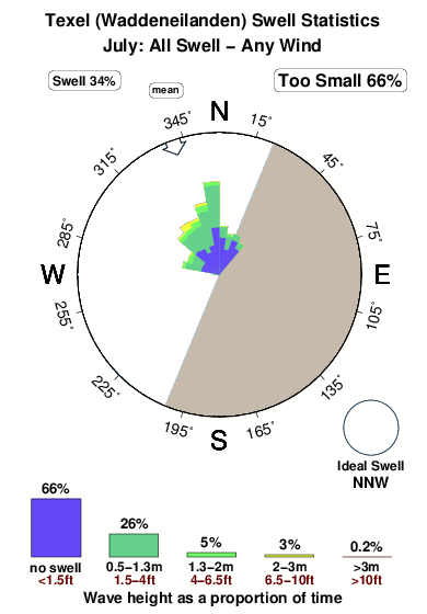
-°COverall Texel (Waddeneilanden) Surf Consistency and Wind Distribution in Julho


Wind stats for Texel (Waddeneilanden): see the variation in direction and stength by month.
fotos da galeria
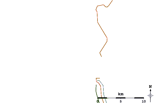
Contornos: Estradas & Rios: Escolha um spot de surf da lista 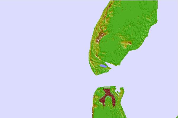

Use este mapa de relevo para navegar até Netherlands surf quebras e estações que estão na área de maré Texel (Waddeneilanden)
Outros Spots de Surf mais próximos de Texel (Waddeneilanden):
(Clique no nome do local para maiores detalhes)- Closest spot6 mi
- Second closest spot14 mi
- Third closest spot15 mi
- Fourth closest spot16 mi
- Fifth closest spot25 mi
Bóias ondográficas mais próxima de Texel (Waddeneilanden):
- Closest bóia ondográfica71 mi
- Second closest bóia ondográfica78 mi
- Third closest bóia ondográfica80 mi
- Fourth closest bóia ondográfica91 mi
- Fifth closest bóia ondográfica108 mi
Estações de maré mais próximo de Texel (Waddeneilanden):
- Closest estação de maréDen Helder4 mi
- Second closest estação de maréDen Burg5 mi
- Third closest estação de maréOude Schild6 mi
- Fourth closest estação de maréTexel Noordzee7 mi
- Fifth closest estação de maréPetten zuid17 mi
Airports
- The closest passenger airport to Texel (Waddeneilanden) is De Kooy Airport (DHR) in Netherlands, 11 km (7 miles) away (directly).
- The second nearest airport to Texel (Waddeneilanden) is Leeuwarden Airport (LWR), also in Netherlands, 74 km (46 miles) away.
- Third is Schiphol (Amsterdam) Airport (AMS) in Netherlands, 79 km (49 miles) away.
- Valkenburg Airport (LID) in Netherlands is 96 km (60 miles) away.
- Soesterberg Airport (UTC), also in Netherlands is the fifth nearest airport to Texel (Waddeneilanden) and is 106 km (66 miles) away.
- /breaks/Texel_Waddeneilanden/forecasts/latest


 Nearest