

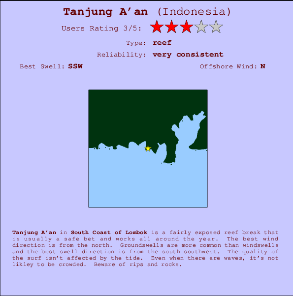
Tanjung A'an Surf Guide
Tanjung A'an in South Lombok is a fairly exposed reef break that has very consistent surf and works all around the year. Offshore winds are from the north. Most of the surf here comes from groundswells and the best swell direction is from the south southwest. A right hand reef. The quality of the surf isn't affected by the tide. Even when there are waves, it's not likley to be crowded. Hazards include rips and rocks.
Tanjung A'an Spot Info
| Type: | Rating: | Reliability: | Todays Sea Temp*: |
|---|---|---|---|
| very consistent | 26.5°C*ocean temperature recorded from satellite |
Surfing Tanjung A'an:
The best conditions reported for surf at Tanjung A'an occur when a South-southwest swell combines with an offshore wind direction from the North.

Previsão da Energia de Ondas (Força): 12hrs


Tanjung A'an Surf:
Sunday, 26 July 2026, 19:50 Local time| Domingo 26 | Seg | |||
| 5PM | 8PM | 11PM | 2AM | |
| Wave (m) | ||||
| Período (s) | 9 | 9 | 9 | 9 |
| Vento (km/h) | ||||
| Estado do Vento | cross- on |
cross- on |
cross- on |
cross- on |
- /breaks/Tanjung-Aan/forecasts/latest
Tanjung A'an Surf Guide
Tanjung A'an in South Lombok is a fairly exposed reef break that has very consistent surf and works all around the year. Offshore winds are from the north. Most of the surf here comes from groundswells and the best swell direction is from the south southwest. A right hand reef. The quality of the surf isn't affected by the tide. Even when there are waves, it's not likley to be crowded. Hazards include rips and rocks.
Tanjung A'an Spot Info
Type: Rating: Reliability: Todays Sea Temp*:  Reef
Reef 3
3very consistent 26.5°C*ocean temperature recorded from satelliteSurfing Tanjung A'an:
The best conditions reported for surf at Tanjung A'an occur when a South-southwest swell combines with an offshore wind direction from the North.
Previsão da Energia de Ondas (Força): 12hrs
Use a aba navegação acima para ver temperatura do mar em Tanjung A'an, fotografias de Tanjung A'an, previsões detalhadas do swell em Tanjung A'an, previsões do vento e do tempo, webcams em Tanjung A'an , vento atual em Lombok - South com base em dados ao vivo fornecidos por estações de meteorologia e previsões da maré em Tanjung A'an. O link para os mapas do swell em Indonesia abrirá uma imagem ampliada monstrando Indonesia e os mares próximos. Estes mapas do swell podem ser animados para mostrar diferentes componentes do swell, energia das ondas, período das ondas, altura das ondas, assim como previsões do vento e do tempo, observações em tempo real do estado do tempo e do mar graças às bóias de Indonesia, navios passantes e estações de meteorologia presentes na costa. Cada uma das páginas de previsão para este surf break apresenta as ferramentas do buscador global e regional para localizar as melores condições de surf na área ao redor de Tanjung A'an.
Tanjung A'an Surf:
Sunday, 26 July 2026, 19:50 Local timeDomingo 26 Seg 5PM 8PM 11PM 2AM Wave (m) Período (s) 9 9 9 9 Vento (km/h) Estado do Vento cross-
oncross-
oncross-
oncross-
on- /breaks/Tanjung-Aan/forecasts/latest
- /breaks/Tanjung-Aan/forecasts/latest/six_day
Tanjung A'an Surf Guide
Tanjung A'an in South Lombok is a fairly exposed reef break that has very consistent surf and works all around the year. Offshore winds are from the north. Most of the surf here comes from groundswells and the best swell direction is from the south southwest. A right hand reef. The quality of the surf isn't affected by the tide. Even when there are waves, it's not likley to be crowded. Hazards include rips and rocks.
Tanjung A'an Spot Info
Type: Rating: Reliability: Todays Sea Temp*: Reef3very consistent 26.5°C*ocean temperature recorded from satelliteSurfing Tanjung A'an:
The best conditions reported for surf at Tanjung A'an occur when a South-southwest swell combines with an offshore wind direction from the North.
Previsão da Energia de Ondas (Força): 12hrs
Use a aba navegação acima para ver temperatura do mar em Tanjung A'an, fotografias de Tanjung A'an, previsões detalhadas do swell em Tanjung A'an, previsões do vento e do tempo, webcams em Tanjung A'an , vento atual em Lombok - South com base em dados ao vivo fornecidos por estações de meteorologia e previsões da maré em Tanjung A'an. O link para os mapas do swell em Indonesia abrirá uma imagem ampliada monstrando Indonesia e os mares próximos. Estes mapas do swell podem ser animados para mostrar diferentes componentes do swell, energia das ondas, período das ondas, altura das ondas, assim como previsões do vento e do tempo, observações em tempo real do estado do tempo e do mar graças às bóias de Indonesia, navios passantes e estações de meteorologia presentes na costa. Cada uma das páginas de previsão para este surf break apresenta as ferramentas do buscador global e regional para localizar as melores condições de surf na área ao redor de Tanjung A'an.
Tanjung A'an Surf:
Sunday, 26 July 2026, 19:50 Local timeDomingo 26 Seg 5PM 8PM 11PM 2AM Wave (m) Período (s) 9 9 9 9 Vento (km/h) Estado do Vento cross-
oncross-
oncross-
oncross-
on- /breaks/Tanjung-Aan/forecasts/latest
Tanjung A'an Surf Guide
Tanjung A'an in South Lombok is a fairly exposed reef break that has very consistent surf and works all around the year. Offshore winds are from the north. Most of the surf here comes from groundswells and the best swell direction is from the south southwest. A right hand reef. The quality of the surf isn't affected by the tide. Even when there are waves, it's not likley to be crowded. Hazards include rips and rocks.
Tanjung A'an Spot Info
Type: Rating: Reliability: Todays Sea Temp*: Reef3very consistent 26.5°C*ocean temperature recorded from satelliteSurfing Tanjung A'an:
The best conditions reported for surf at Tanjung A'an occur when a South-southwest swell combines with an offshore wind direction from the North.
Previsão da Energia de Ondas (Força): 12hrs
Use a aba navegação acima para ver temperatura do mar em Tanjung A'an, fotografias de Tanjung A'an, previsões detalhadas do swell em Tanjung A'an, previsões do vento e do tempo, webcams em Tanjung A'an , vento atual em Lombok - South com base em dados ao vivo fornecidos por estações de meteorologia e previsões da maré em Tanjung A'an. O link para os mapas do swell em Indonesia abrirá uma imagem ampliada monstrando Indonesia e os mares próximos. Estes mapas do swell podem ser animados para mostrar diferentes componentes do swell, energia das ondas, período das ondas, altura das ondas, assim como previsões do vento e do tempo, observações em tempo real do estado do tempo e do mar graças às bóias de Indonesia, navios passantes e estações de meteorologia presentes na costa. Cada uma das páginas de previsão para este surf break apresenta as ferramentas do buscador global e regional para localizar as melores condições de surf na área ao redor de Tanjung A'an.
Tanjung A'an Surf:
Sunday, 26 July 2026, 19:50 Local timeDomingo 26 Seg 5PM 8PM 11PM 2AM Wave (m) Período (s) 9 9 9 9 Vento (km/h) Estado do Vento cross-
oncross-
oncross-
oncross-
onTide Times:
Para Aan %{dist} %{km} de %{location}
A PRÓXIMA É ÀS (hora local) faltam maré alta maré baixa Tanjung A'an Tide Times and Tide Chart
Live Weather:
At Bandara Airport, 20 km from Tanjung A'an.
moderate winds from the SE
(km/h)
Dry and partly cloudyAir temperature
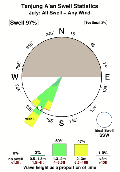
25°COverall Tanjung A'an Surf Consistency and Wind Distribution in Julho
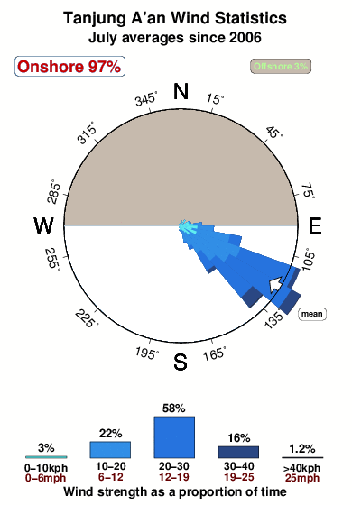


Wind stats for Tanjung A'an: see the variation in direction and stength by month.
fotos da galeria
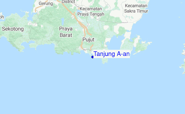
Contornos: Estradas & Rios: Escolha um spot de surf da lista 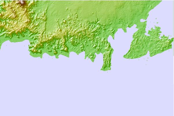
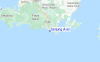
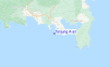
Use este mapa de relevo para navegar até Lombok - South surf quebras e estações que estão na área de maré Tanjung A'an
Outros Spots de Surf mais próximos de Tanjung A'an:
(Clique no nome do local para maiores detalhes)- Closest spot2 mi
- Second closest spot2 mi
- Third closest spot2 mi
- Fourth closest spot2 mi
- Fifth closest spot3 mi
Bóias ondográficas mais próxima de Tanjung A'an:
- Closest bóia ondográfica1740 mi
- Second closest bóia ondográfica2050 mi
- Third closest bóia ondográfica2175 mi
- Fourth closest bóia ondográfica2253 mi
- Fifth closest bóia ondográfica2270 mi
Estações de maré mais próximo de Tanjung A'an:
- Closest estação de maréMataram27 mi
- Second closest estação de maréDenpasar78 mi
- Third closest estação de maréSumbawa Besar81 mi
- Fourth closest estação de maréSingaraja101 mi
- Fifth closest estação de maréBanjar106 mi
Airports
- The closest passenger airport to Tanjung A'an is Selaparang (Mataram) Airport (AMI) in Indonesia, which is 48 km (30 miles) away (directly).
- The second nearest airport to Tanjung A'an is Bali International (Denpasar) Airport (DPS), also in Indonesia, 129 km (80 miles) away.
- The third closest airport is Sumbawa Besar Airport (SWG), also in Indonesia, 129 km (80 miles) away.
- /breaks/Tanjung-Aan/forecasts/latest
 Nearest