
Previsão:

Previsão de curto prazoprincipalmente seco. Warm (máx. 23°C na Terça à tarde, mín 14°C no Domingo à noite). o vento será geralmente fraco. | ||||||||||||||||||||||
Domingo 19 | Segunda-feira 20 | Terça-feira 21 | ||||||||||||||||||||
8 AM | 11 AM | 2 PM | 5 PM | 8 PM | 11 PM | 2 AM | 5 AM | 8 AM | 11 AM | 2 PM | 5 PM | 8 PM | 11 PM | 2 AM | 5 AM | 8 AM | 11 AM | 2 PM | 5 PM | 8 PM | 11 PM | |
Mapa da altura do Swell |  |  |  |  |  |  | 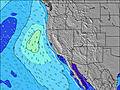 |  | ||||||||||||||
Swell Altura (m) Direção Período (s) | SW 16 | SW 17 | SW 17 | SW 17 | SW 17 | SW 16 | S 12 | SW 16 | S 12 | SSW 16 | SW 16 | SW 16 | SW 16 | S 11 | SSW 16 | SSW 16 | SSW 17 | SSW 17 | SSW 15 | SSW 15 | SSW 15 | SSW 15 |
Onda Gráfico | ||||||||||||||||||||||
264 | 358 | 439 | 439 | 424 | 326 | 285 | 261 | 280 | 314 | 255 | 362 | 367 | 242 | 397 | 306 | 443 | 329 | 498 | 272 | 422 | 428 | |
Vento (km/h) | ||||||||||||||||||||||
Estado do Vento maral cruzado-maral Cruzado cruzado-terral terral cristalino | glassy | on | on | on | cross-on | cross-on | glassy | cross-on | cross-on | on | on | on | cross-on | cross-on | glassy | cross-on | glassy | on | on | on | on | glassy |
Maré Alta | 3:19PM1.88m | 3:16AM1.46m | 4:02PM1.90m | 4:48AM1.30m | 4:47PM1.91m | |||||||||||||||||
Maré Baixa | 8:31AM0.57m | 9:46PM0.88m | 9:08AM0.77m | 11:06PM0.79m | 9:48AM0.96m | |||||||||||||||||
6:01 | — | — | — | — | — | — | 6:03 | — | — | — | — | — | — | — | 6:03 | — | — | — | — | — | — | |
— | — | — | — | 8:17 | — | — | — | — | — | — | — | 8:16 | — | — | — | — | — | — | — | 8:16 | — | |
mm | — | — | — | — | — | — | — | — | — | — | — | — | — | — | — | — | — | — | — | — | — | — |
Temp. °C | 15 | 19 | 19 | 18 | 15 | 14 | 15 | 15 | 17 | 21 | 21 | 21 | 18 | 17 | 18 | 18 | 20 | 22 | 23 | 23 | 19 | 18 |
Ressent. °C | 15 | 18 | 17 | 16 | 13 | 13 | 15 | 14 | 16 | 20 | 19 | 18 | 16 | 16 | 17 | 17 | 19 | 21 | 21 | 20 | 17 | 18 |
Swell 1 Altura (m) Direção Período (s) | WNW 6 | SW 17 | SW 17 | SW 17 | S 13 | S 12 | S 12 | S 12 | S 12 | S 11 | S 12 | S 12 | S 11 | S 11 | SSW 16 | S 11 | S 11 | SSW 17 | SSW 15 | SSW 12 | SSW 15 | WNW 6 |
48 | 358 | 439 | 439 | 263 | 295 | 285 | 228 | 280 | 151 | 216 | 282 | 255 | 242 | 397 | 146 | 248 | 329 | 498 | 236 | 422 | 65 | |
Swell 2 Altura (m) Direção Período (s) | SW 16 | WNW 16 | WNW 16 | S 13 | SW 17 | WNW 9 | SW 16 | SW 16 | SW 16 | SSW 16 | SW 16 | SW 16 | SW 16 | SW 16 | S 11 | SSW 16 | SSW 17 | S 10 | S 10 | SSW 15 | SSW 12 | SSW 15 |
264 | 212 | 212 | 171 | 424 | 101 | 268 | 261 | 258 | 314 | 255 | 362 | 367 | 157 | 196 | 306 | 443 | 133 | 94 | 272 | 232 | 428 | |
Swell 3 Altura (m) Direção Período (s) | WNW 16 | S 11 | S 14 | WNW 15 | WNW 15 | SW 16 | WNW 15 | WNW 9 | WNW 8 | S 13 | S 14 | WNW 14 | WNW 14 | SSW 16 | WNW 5 | SSW 13 | WNW 5 | SSW 13 | WNW 13 | S 17 | WNW 13 | SSW 12 |
215 | 61 | 131 | 186 | 184 | 326 | 121 | 67 | 64 | 167 | 132 | 118 | 118 | 138 | 22 | 156 | 21 | 151 | 58 | 147 | 57 | 186 | |
Ondas de vento Altura (m) Direção Período (s) | NW 6 | WNW 6 | WNW 10 | WNW 10 | WNW 5 | NW 9 | NW 9 | NW 8 | — | WNW 8 | WNW 8 | WNW 8 | WNW 4 | WNW 4 | — | NW 5 | WNW 5 | WNW 5 | WNW 5 | WNW 5 | WNW 5 | NW 6 |
83 | 37 | 120 | 145 | 19 | 168 | 148 | 138 | — | 62 | 90 | 123 | 15 | 18 | — | 39 | 47 | 21 | 30 | 42 | 54 | 114 | |
Terral ou glassy mais perto | ||||||||||||||||||||||
Distância (km) | 0 | 174 | 174 | 174 | 56 | 56 | 0 | 56 | 23 | 139 | 174 | 153 | 56 | 2 | 0 | 23 | 0 | 174 | 174 | 200 | 91 | 0 |
Melhor previsões de ondas em San Luis Obispo | ||||||||||||||||||||||
Melhor previsões de ondas em United States | ||||||||||||||||||||||
Buscador de Ondas Global | ||||||||||||||||||||||
- Map Icons:
 Break
Break Live Wave Height (m)
 Live Wind Speed (km/h)
 Surf Rating (10 Max)
 Ocean Swells (m)
- Wind Speed (km/h)
widget de graça do Surf-Forecast.com para o seu site
O relatório de surf / widget do tempo abaixo está disponível para incorporar em sites de terceiros gratuitamente e fornece um resumo das nossas Santa Rosa Creek surf tempo. Simplesmente pegar o trecho de código html que fornecemos e colá-lo em seu próprio site. Você pode escolher seu idioma preferido e unidades métrico/imperial para o surf tempo de alimentação para atender aos usuários do seu site.... Clique aqui para adquirir o código.
 Nearest