
Previsão:

Previsão de curto prazochuva moderada (total 18mm), mais intensa no Sábado à tarde. Warm (máx. 35°C na Qui à tarde, mín 22°C no Sábado à tarde). Ventos aumentam (calmo na Sexta de manhã, ventos frescos de Sudoeste no Sáb à noite). | |||||||||||||||||||||||
Quinta-feira 16 | Sexta-feira 17 | Sábado 18 | |||||||||||||||||||||
5 AM | 8 AM | 11 AM | 2 PM | 5 PM | 8 PM | 11 PM | 2 AM | 5 AM | 8 AM | 11 AM | 2 PM | 5 PM | 8 PM | 11 PM | 2 AM | 5 AM | 8 AM | 11 AM | 2 PM | 5 PM | 8 PM | 11 PM | |
Mapa da altura do Swell |  |  | 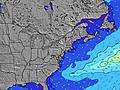 |  | 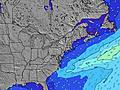 |  |  | 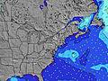 |  | ||||||||||||||
Swell Altura (m) Direção Período (s) | S 5 | S 5 | S 5 | ESE 8 | ESE 8 | S 5 | S 5 | S 5 | S 5 | S 5 | S 5 | S 5 | SSE 5 | S 5 | S 5 | S 5 | S 3 | ESE 8 | S 5 | ESE 8 | S 4 | SSE 4 | SE 13 |
Onda Gráfico | |||||||||||||||||||||||
9 | 9 | 8 | 7 | 7 | 15 | 11 | 11 | 9 | 9 | 8 | 8 | 15 | 14 | 14 | 13 | 3 | 8 | 7 | 7 | 7 | 18 | 7 | |
Vento (km/h) | |||||||||||||||||||||||
Estado do Vento maral cruzado-maral Cruzado cruzado-terral terral cristalino | off | off | off | off | off | cross-off | cross-off | cross-off | cross-off | cross-on | glassy | cross-on | cross-on | cross | cross-off | cross-off | cross-off | cross-off | cross-off | cross-off | cross | cross-off | cross-off |
Maré Alta | 11:27AM1.09m | 11:39PM1.24m | 12:21PM1.10m | 00:32AM1.17m | 1:15PM1.09m | ||||||||||||||||||
Maré Baixa | 5:20AM-0.15m | 5:25PM-0.05m | 6:06AM-0.13m | 6:15PM-0.01m | 6:51AM-0.09m | 7:06PM0.05m | |||||||||||||||||
5:39 | — | — | — | — | — | — | — | 5:39 | — | — | — | — | — | — | — | 5:39 | — | — | — | — | — | — | |
— | — | — | — | — | 8:23 | — | — | — | — | — | — | — | 8:22 | — | — | — | — | — | — | — | 8:22 | — | |
mm | — | — | — | — | — | — | — | — | — | — | — | — | — | — | — | — | — | — | — | 4 | 6 | 1 | 2 |
Temp. °C | 26 | 25 | 29 | 32 | 35 | 32 | 28 | 27 | 24 | 24 | 25 | 26 | 26 | 26 | 24 | 23 | 23 | 23 | 24 | 22 | 22 | 24 | 23 |
Ressent. °C | 25 | 24 | 29 | 31 | 33 | 27 | 25 | 25 | 22 | 21 | 24 | 22 | 22 | 23 | 22 | 23 | 23 | 22 | 23 | 24 | 21 | 23 | 20 |
Swell 1 Altura (m) Direção Período (s) | S 5 | S 5 | S 5 | ESE 8 | ESE 8 | S 5 | S 5 | S 5 | S 5 | S 5 | S 5 | S 5 | ESE 8 | E 3 | ESE 8 | ESE 8 | S 5 | S 5 | SE 8 | ESE 8 | SE 8 | SE 8 | SE 8 |
9 | 9 | 8 | 7 | 7 | 15 | 11 | 11 | 7 | 8 | 8 | 8 | 7 | 1 | 7 | 7 | 2 | 2 | 3 | 7 | 3 | 3 | 3 | |
Swell 2 Altura (m) Direção Período (s) | ESE 8 | ESE 8 | ESE 8 | E 15 | E 15 | ESE 8 | ESE 9 | ESE 9 | SE 9 | SE 9 | SE 8 | ESE 8 | SE 14 | ESE 8 | E 3 | — | SE 8 | ESE 8 | SE 14 | S 5 | SE 13 | SE 13 | SE 13 |
7 | 7 | 7 | 5 | 4 | 7 | 7 | 7 | 3 | 3 | 3 | 7 | 8 | 7 | 1 | — | 3 | 7 | 7 | 2 | 7 | 7 | 7 | |
Swell 3 Altura (m) Direção Período (s) | E 16 | E 16 | E 16 | — | — | E 15 | E 15 | E 15 | SE 15 | SE 15 | SE 15 | SE 14 | SE 14 | SE 14 | SE 14 | SE 14 | — | SE 14 | E 9 | SE 13 | — | E 8 | — |
5 | 5 | 5 | — | — | 4 | 4 | 4 | 9 | 9 | 8 | 8 | 8 | 8 | 8 | 8 | — | 8 | 2 | 7 | — | 1 | — | |
Ondas de vento Altura (m) Direção Período (s) | — | — | — | SSW 5 | S 4 | NW 3 | NNW 3 | NNW 3 | NNW 3 | N 3 | NE 3 | E 3 | SSE 5 | S 5 | S 5 | S 5 | S 3 | S 3 | S 5 | S 3 | S 4 | SSE 4 | SSW 5 |
— | — | — | 9 | 12 | 2 | 7 | 4 | 2 | 1 | 2 | 1 | 15 | 14 | 14 | 13 | 3 | 2 | 7 | 3 | 6 | 18 | 105 | |
Terral ou glassy mais perto | |||||||||||||||||||||||
Distância (km) | 170 | 170 | 1296 | 1210 | 1296 | 66 | 134 | 170 | 170 | 2304 | 2607 | 851 | 859 | 1296 | 1566 | 983 | 859 | 862 | 3319 | 2573 | 201 | 491 | 1297 |
Melhor previsões de ondas em New Jersey | |||||||||||||||||||||||
Melhor previsões de ondas em United States | |||||||||||||||||||||||
Buscador de Ondas Global | |||||||||||||||||||||||
- Map Icons:
 Break
Break Live Wave Height (m)
 Live Wind Speed (km/h)
 Surf Rating (10 Max)
 Ocean Swells (m)
- Wind Speed (km/h)
widget de graça do Surf-Forecast.com para o seu site
O relatório de surf / widget do tempo abaixo está disponível para incorporar em sites de terceiros gratuitamente e fornece um resumo das nossas Sands surf tempo. Simplesmente pegar o trecho de código html que fornecemos e colá-lo em seu próprio site. Você pode escolher seu idioma preferido e unidades métrico/imperial para o surf tempo de alimentação para atender aos usuários do seu site.... Clique aqui para adquirir o código.
 Nearest