

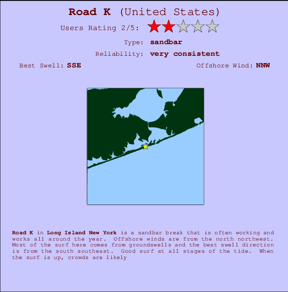
Road K Surf Guide
Road K in Long Island New York is an exposed sandbar break that has very consistent waves and works all around the year. The best wind direction is from the north northwest. Most of the surf here comes from groundswells and the ideal swell direction is from the south southeast. Good surf at all stages of the tide. A popular wave that can get growded.
Road K Spot Info
| Type: | Rating: | Reliability: | Todays Sea Temp*: |
|---|---|---|---|
| very consistent | 22.6°C*ocean temperature recorded from satellite |
Surfing Road K:
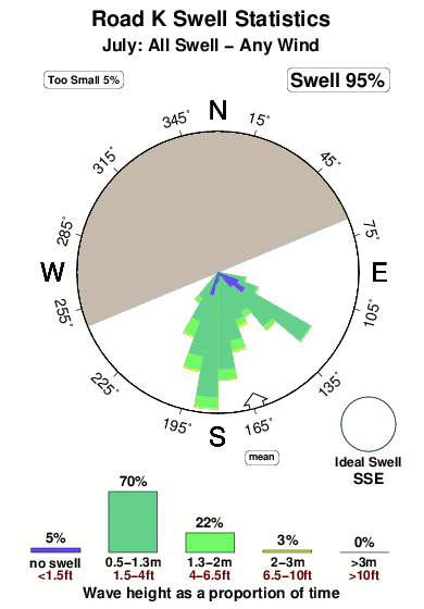
The best conditions reported for surf at Road K occur when a South-southeast swell combines with an offshore wind direction from the North-northwest.
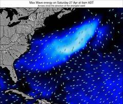
Previsão da Energia de Ondas (Força): 12hrs

Road K Surf:
Saturday, 18 July 2026, 15:45 Local time| Sábado 18 | ||||
| 11AM | 2PM | 5PM | 8PM | |
| Wave (m) | ||||
| Período (s) | 4 | 4 | 4 | 5 |
| Vento (km/h) | ||||
| Estado do Vento | cross- on |
cross- on |
cross- on |
cross- on |
- /breaks/Road-K/forecasts/latest
Road K Surf Guide
Road K in Long Island New York is an exposed sandbar break that has very consistent waves and works all around the year. The best wind direction is from the north northwest. Most of the surf here comes from groundswells and the ideal swell direction is from the south southeast. Good surf at all stages of the tide. A popular wave that can get growded.
Road K Spot Info
Type: Rating: Reliability: Todays Sea Temp*:  Sandbar
 2
2very consistent 22.6°C*ocean temperature recorded from satelliteSurfing Road K:
The best conditions reported for surf at Road K occur when a South-southeast swell combines with an offshore wind direction from the North-northwest.
Previsão da Energia de Ondas (Força): 12hrs
Use a aba navegação acima para ver temperatura do mar em Road K, fotografias de Road K, previsões detalhadas do swell em Road K, previsões do vento e do tempo, webcams em Road K , vento atual em Long Island NY com base em dados ao vivo fornecidos por estações de meteorologia e previsões da maré em Road K. O link para os mapas do swell em United States abrirá uma imagem ampliada monstrando United States e os mares próximos. Estes mapas do swell podem ser animados para mostrar diferentes componentes do swell, energia das ondas, período das ondas, altura das ondas, assim como previsões do vento e do tempo, observações em tempo real do estado do tempo e do mar graças às bóias de United States, navios passantes e estações de meteorologia presentes na costa. Cada uma das páginas de previsão para este surf break apresenta as ferramentas do buscador global e regional para localizar as melores condições de surf na área ao redor de Road K.
Road K Surf:
Saturday, 18 July 2026, 15:45 Local timeSábado 18 11AM 2PM 5PM 8PM Wave (m) Período (s) 4 4 4 5 Vento (km/h) Estado do Vento cross-
oncross-
oncross-
oncross-
on- /breaks/Road-K/forecasts/latest
- /breaks/Road-K/forecasts/latest/six_day
Road K Surf Guide
Road K in Long Island New York is an exposed sandbar break that has very consistent waves and works all around the year. The best wind direction is from the north northwest. Most of the surf here comes from groundswells and the ideal swell direction is from the south southeast. Good surf at all stages of the tide. A popular wave that can get growded.
Road K Spot Info
Type: Rating: Reliability: Todays Sea Temp*: Sandbar2very consistent 22.6°C*ocean temperature recorded from satelliteSurfing Road K:
The best conditions reported for surf at Road K occur when a South-southeast swell combines with an offshore wind direction from the North-northwest.
Previsão da Energia de Ondas (Força): 12hrs
Use a aba navegação acima para ver temperatura do mar em Road K, fotografias de Road K, previsões detalhadas do swell em Road K, previsões do vento e do tempo, webcams em Road K , vento atual em Long Island NY com base em dados ao vivo fornecidos por estações de meteorologia e previsões da maré em Road K. O link para os mapas do swell em United States abrirá uma imagem ampliada monstrando United States e os mares próximos. Estes mapas do swell podem ser animados para mostrar diferentes componentes do swell, energia das ondas, período das ondas, altura das ondas, assim como previsões do vento e do tempo, observações em tempo real do estado do tempo e do mar graças às bóias de United States, navios passantes e estações de meteorologia presentes na costa. Cada uma das páginas de previsão para este surf break apresenta as ferramentas do buscador global e regional para localizar as melores condições de surf na área ao redor de Road K.
Road K Surf:
Saturday, 18 July 2026, 15:45 Local timeSábado 18 11AM 2PM 5PM 8PM Wave (m) Período (s) 4 4 4 5 Vento (km/h) Estado do Vento cross-
oncross-
oncross-
oncross-
on- /breaks/Road-K/forecasts/latest
Road K Surf Guide
Road K in Long Island New York is an exposed sandbar break that has very consistent waves and works all around the year. The best wind direction is from the north northwest. Most of the surf here comes from groundswells and the ideal swell direction is from the south southeast. Good surf at all stages of the tide. A popular wave that can get growded.
Road K Spot Info
Type: Rating: Reliability: Todays Sea Temp*: Sandbar2very consistent 22.6°C*ocean temperature recorded from satelliteSurfing Road K:
The best conditions reported for surf at Road K occur when a South-southeast swell combines with an offshore wind direction from the North-northwest.
Previsão da Energia de Ondas (Força): 12hrs
Use a aba navegação acima para ver temperatura do mar em Road K, fotografias de Road K, previsões detalhadas do swell em Road K, previsões do vento e do tempo, webcams em Road K , vento atual em Long Island NY com base em dados ao vivo fornecidos por estações de meteorologia e previsões da maré em Road K. O link para os mapas do swell em United States abrirá uma imagem ampliada monstrando United States e os mares próximos. Estes mapas do swell podem ser animados para mostrar diferentes componentes do swell, energia das ondas, período das ondas, altura das ondas, assim como previsões do vento e do tempo, observações em tempo real do estado do tempo e do mar graças às bóias de United States, navios passantes e estações de meteorologia presentes na costa. Cada uma das páginas de previsão para este surf break apresenta as ferramentas do buscador global e regional para localizar as melores condições de surf na área ao redor de Road K.
Road K Surf:
Saturday, 18 July 2026, 15:45 Local timeSábado 18 11AM 2PM 5PM 8PM Wave (m) Período (s) 4 4 4 5 Vento (km/h) Estado do Vento cross-
oncross-
oncross-
oncross-
onTide Times:
Para Shinnecock Inlet (ocean), Long Island, New York %{dist} %{km} de %{location}
A PRÓXIMA É ÀS (hora local) faltam maré alta maré baixa Road K Tide Times and Tide Chart
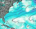
Live Weather:
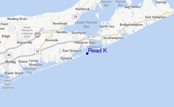
At Westhampton Beach/Francis S. Gabreski Airport, 9 km from Road K.
light winds from the S
(km/h)Air temperature
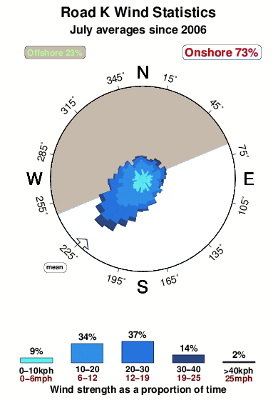
20.0°COverall Road K Surf Consistency and Wind Distribution in Julho
fotos da galeria
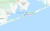
Contornos: Estradas & Rios: Escolha um spot de surf da lista 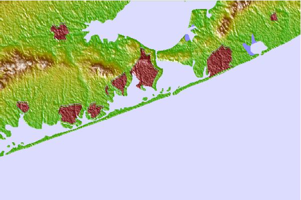
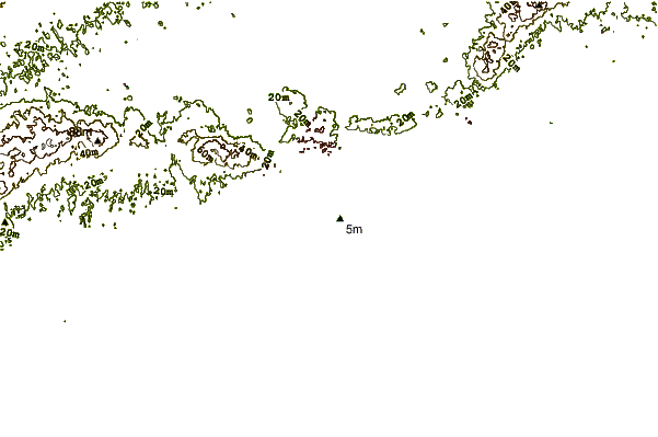
Use este mapa de relevo para navegar até Long Island NY surf quebras e estações que estão na área de maré Road K
Outros Spots de Surf mais próximos de Road K:
(Clique no nome do local para maiores detalhes)- Closest spot1 mi
- Second closest spot2 mi
- Third closest spot2 mi
- Fourth closest spot9 mi
- Fifth closest spot11 mi
Bóias ondográficas mais próxima de Road K:
- Closest bóia ondográfica22 mi
- Second closest bóia ondográfica26 mi
- Third closest bóia ondográfica53 mi
- Fourth closest bóia ondográfica57 mi
- Fifth closest bóia ondográfica70 mi
Estações de maré mais próximo de Road K:
- Closest estação de maréPonquogue Bridge1 mi
- Second closest estação de maréPonquoque Point, Shinnecock Bay1 mi
- Third closest estação de maréShinnecock Inlet (ocean), Long Island2 mi
- Fourth closest estação de maréShinnecock Yacht Club, Penniman Creek, Shinnecock Bay2 mi
- Fifth closest estação de maréShinnecock Bay entrance, Shinnecock Bay3 mi
Airports
- The closest passenger airport to Road K is The Francis S Gabreski (West Hampton Beach) Airport (FOK) in USA, 10 km (6 miles) away (directly).
- The second nearest airport to Road K is Long Island Mac Arthur (Islip) Airport (ISP), also in USA, 50 km (31 miles) away.
- Third is Igor I Sikorsky Mem (Stratford) Airport (BDR) in USA, 63 km (39 miles) away.
- Hartford Brainard Airport (HFD) in USA is 101 km (63 miles) away.
- Westchester Co (White Plains) Airport (HPN), also in USA is the fifth nearest airport to Road K and is 104 km (65 miles) away.
- /breaks/Road-K/forecasts/latest


 Nearest