
Rabbit/Manana Island Surf Guide
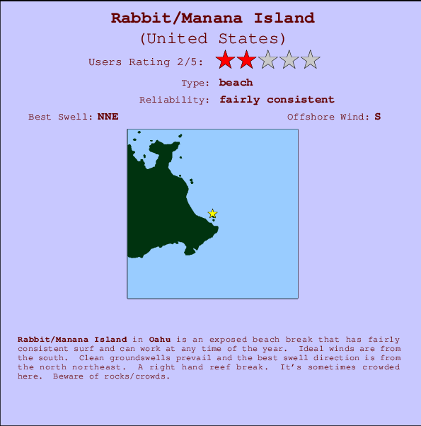
Rabbit/Manana Island in Oahu is an exposed beach break that has fairly consistent surf and can work at any time of the year. Offshore winds blow from the south. Groundswells more frequent than windswells and the ideal swell angle is from the north northeast. A right hand reef break. When the surf is up, it can get quite busy in the water. Take care of rocks/crowds.
Rabbit/Manana Island Spot Info
| Type: | Rating: | Reliability: | Todays Sea Temp*: |
|---|---|---|---|
| fairly consistent | 26.1°C*ocean temperature recorded from satellite |
Surfing Rabbit/Manana Island:
The best conditions reported for surf at Rabbit/Manana Island occur when a North-northeast swell combines with an offshore wind direction from the South.
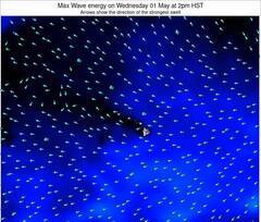
Previsão da Energia de Ondas (Força): 12hrs

Rabbit/Manana Island Surf:
Tuesday, 14 July 2026, 15:16 Local time| Terça-feira 14 | ||||
| 11AM | 2PM | 5PM | 8PM | |
| Wave (m) | ||||
| Período (s) | 7 | 7 | 7 | 8 |
| Vento (km/h) | ||||
| Estado do Vento | cross- on |
cross- on |
cross- on |
cross- on |
- /breaks/Rabbit-Manana-Island/forecasts/latest

Rabbit/Manana Island Surf Guide
Rabbit/Manana Island in Oahu is an exposed beach break that has fairly consistent surf and can work at any time of the year. Offshore winds blow from the south. Groundswells more frequent than windswells and the ideal swell angle is from the north northeast. A right hand reef break. When the surf is up, it can get quite busy in the water. Take care of rocks/crowds.
Rabbit/Manana Island Spot Info
Type: Rating: Reliability: Todays Sea Temp*:  Beach
Beach 2
2fairly consistent 26.1°C*ocean temperature recorded from satelliteSurfing Rabbit/Manana Island:
The best conditions reported for surf at Rabbit/Manana Island occur when a North-northeast swell combines with an offshore wind direction from the South.
Previsão da Energia de Ondas (Força): 12hrs
Use a aba navegação acima para ver temperatura do mar em Rabbit/Manana Island, fotografias de Rabbit/Manana Island, previsões detalhadas do swell em Rabbit/Manana Island, previsões do vento e do tempo, webcams em Rabbit/Manana Island , vento atual em HAW - Oahu com base em dados ao vivo fornecidos por estações de meteorologia e previsões da maré em Rabbit/Manana Island. O link para os mapas do swell em United States abrirá uma imagem ampliada monstrando United States e os mares próximos. Estes mapas do swell podem ser animados para mostrar diferentes componentes do swell, energia das ondas, período das ondas, altura das ondas, assim como previsões do vento e do tempo, observações em tempo real do estado do tempo e do mar graças às bóias de United States, navios passantes e estações de meteorologia presentes na costa. Cada uma das páginas de previsão para este surf break apresenta as ferramentas do buscador global e regional para localizar as melores condições de surf na área ao redor de Rabbit/Manana Island.
Rabbit/Manana Island Surf:
Tuesday, 14 July 2026, 15:16 Local timeTerça-feira 14 11AM 2PM 5PM 8PM Wave (m) Período (s) 7 7 7 8 Vento (km/h) Estado do Vento cross-
oncross-
oncross-
oncross-
on- /breaks/Rabbit-Manana-Island/forecasts/latest
- /breaks/Rabbit-Manana-Island/forecasts/latest/six_day
Rabbit/Manana Island Surf Guide
Rabbit/Manana Island in Oahu is an exposed beach break that has fairly consistent surf and can work at any time of the year. Offshore winds blow from the south. Groundswells more frequent than windswells and the ideal swell angle is from the north northeast. A right hand reef break. When the surf is up, it can get quite busy in the water. Take care of rocks/crowds.
Rabbit/Manana Island Spot Info
Type: Rating: Reliability: Todays Sea Temp*: Beach2fairly consistent 26.1°C*ocean temperature recorded from satelliteSurfing Rabbit/Manana Island:
The best conditions reported for surf at Rabbit/Manana Island occur when a North-northeast swell combines with an offshore wind direction from the South.
Previsão da Energia de Ondas (Força): 12hrs
Use a aba navegação acima para ver temperatura do mar em Rabbit/Manana Island, fotografias de Rabbit/Manana Island, previsões detalhadas do swell em Rabbit/Manana Island, previsões do vento e do tempo, webcams em Rabbit/Manana Island , vento atual em HAW - Oahu com base em dados ao vivo fornecidos por estações de meteorologia e previsões da maré em Rabbit/Manana Island. O link para os mapas do swell em United States abrirá uma imagem ampliada monstrando United States e os mares próximos. Estes mapas do swell podem ser animados para mostrar diferentes componentes do swell, energia das ondas, período das ondas, altura das ondas, assim como previsões do vento e do tempo, observações em tempo real do estado do tempo e do mar graças às bóias de United States, navios passantes e estações de meteorologia presentes na costa. Cada uma das páginas de previsão para este surf break apresenta as ferramentas do buscador global e regional para localizar as melores condições de surf na área ao redor de Rabbit/Manana Island.
Rabbit/Manana Island Surf:
Tuesday, 14 July 2026, 15:16 Local timeTerça-feira 14 11AM 2PM 5PM 8PM Wave (m) Período (s) 7 7 7 8 Vento (km/h) Estado do Vento cross-
oncross-
oncross-
oncross-
on- /breaks/Rabbit-Manana-Island/forecasts/latest
Rabbit/Manana Island Surf Guide
Rabbit/Manana Island in Oahu is an exposed beach break that has fairly consistent surf and can work at any time of the year. Offshore winds blow from the south. Groundswells more frequent than windswells and the ideal swell angle is from the north northeast. A right hand reef break. When the surf is up, it can get quite busy in the water. Take care of rocks/crowds.
Rabbit/Manana Island Spot Info
Type: Rating: Reliability: Todays Sea Temp*: Beach2fairly consistent 26.1°C*ocean temperature recorded from satelliteSurfing Rabbit/Manana Island:
The best conditions reported for surf at Rabbit/Manana Island occur when a North-northeast swell combines with an offshore wind direction from the South.
Previsão da Energia de Ondas (Força): 12hrs
Use a aba navegação acima para ver temperatura do mar em Rabbit/Manana Island, fotografias de Rabbit/Manana Island, previsões detalhadas do swell em Rabbit/Manana Island, previsões do vento e do tempo, webcams em Rabbit/Manana Island , vento atual em HAW - Oahu com base em dados ao vivo fornecidos por estações de meteorologia e previsões da maré em Rabbit/Manana Island. O link para os mapas do swell em United States abrirá uma imagem ampliada monstrando United States e os mares próximos. Estes mapas do swell podem ser animados para mostrar diferentes componentes do swell, energia das ondas, período das ondas, altura das ondas, assim como previsões do vento e do tempo, observações em tempo real do estado do tempo e do mar graças às bóias de United States, navios passantes e estações de meteorologia presentes na costa. Cada uma das páginas de previsão para este surf break apresenta as ferramentas do buscador global e regional para localizar as melores condições de surf na área ao redor de Rabbit/Manana Island.
Rabbit/Manana Island Surf:
Tuesday, 14 July 2026, 15:16 Local timeTerça-feira 14 11AM 2PM 5PM 8PM Wave (m) Período (s) 7 7 7 8 Vento (km/h) Estado do Vento cross-
oncross-
oncross-
oncross-
onTide Times:
Para Waimanalo, Oahu Island, Hawaii %{dist} %{km} de %{location}
A PRÓXIMA É ÀS (hora local) faltam maré alta maré baixa Rabbit/Manana Island Tide Times and Tide Chart
Live Weather:
At Mokapu Point- HI, 9 km from Rabbit/Manana Island.
- Air temperature
-°CCurrent weather near Rabbit/Manana Island
Buoy Data:
At Mokapu Point, HI, 6 miles from Rabbit/Manana Island.
10AM 11AM 12PM 1PM Idade dos dados 5 hr 4 hr 3 hr 2 hr Altura de onda (m) 

Período Dominante (s) 8 8 8 8 Overall Rabbit/Manana Island Surf Consistency and Wind Distribution in Julho


Wind stats for Rabbit/Manana Island: see the variation in direction and stength by month.
fotos da galeria
Contornos: Estradas & Rios: Escolha um spot de surf da lista 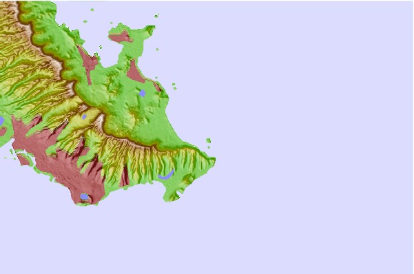
Use este mapa de relevo para navegar até HAW - Oahu surf quebras e estações que estão na área de maré Rabbit/Manana Island
Outros Spots de Surf mais próximos de Rabbit/Manana Island:
(Clique no nome do local para maiores detalhes)- Closest spot1 mi
- Second closest spot1 mi
- Third closest spot2 mi
- Fourth closest spot2 mi
- Fifth closest spot3 mi
Bóias ondográficas mais próxima de Rabbit/Manana Island:
- Closest bóia ondográfica6 mi
- Second closest bóia ondográfica12 mi
- Third closest bóia ondográfica12 mi
- Fourth closest bóia ondográfica19 mi
- Fifth closest bóia ondográfica32 mi
Estações de maré mais próximo de Rabbit/Manana Island:
- Closest estação de maréWaimanalo, Oahu Island2 mi
- Second closest estação de maréHanauma Bay, Oahu Island4 mi
- Third closest estação de maréKailua7 mi
- Fourth closest estação de maréMokuoloe, Kaneohe Bay, Oahu Island11 mi
- Fifth closest estação de maréHonolulu, Oahu (Hawaii)14 mi
Airports
- The closest passenger airport to Rabbit/Manana Island is Kaneohe Bay Mcaf Airport (NGF) in Usa Oahu Isl., 17 km (11 miles) away (directly).
- The second nearest airport to Rabbit/Manana Island is Honolulu International Airport (HNL), also in Usa Oahu Isl., 28 km (17 miles) away.
- Third is Molokai Airport (MKK) in Usa Molokai Isl., 62 km (39 miles) away.
- Dillingham Airport (HDH) in Usa Oahu Isl. is 63 km (39 miles) away.
- Lanai Airport (LNY) in Usa Lanai Isl. is the fifth nearest airport to Rabbit/Manana Island and is 96 km (60 miles) away.
- /breaks/Rabbit-Manana-Island/forecasts/latest


 Nearest