
Previsão:

Previsão de curto prazoChuva intensa (total 61mm), mais intensa durante Quinta à tarde. Warm (máx. 33°C na Terça à tarde, mín 24°C na Qui à tarde). Ventos diminuem (ventos frescos de Oeste na Quarta à tarde, vento fraco de Nor-Noroeste na Quinta à tarde). | |||||||||||||||||||
Ter 28 | Quarta-feira 29 | Quinta-feira 30 | |||||||||||||||||
4 PM | 7 PM | 10 PM | 1 AM | 4 AM | 7 AM | 10 AM | 1 PM | 4 PM | 7 PM | 10 PM | 1 AM | 4 AM | 7 AM | 10 AM | 1 PM | 4 PM | 7 PM | 10 PM | |
Mapa da altura do Swell |  | 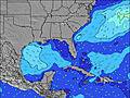 | 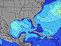 |  | 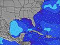 | 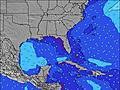 |  | ||||||||||||
Swell Altura (m) Direção Período (s) | SW 4 | WSW 4 | WSW 4 | WSW 4 | WSW 4 | W 4 | WSW 4 | WSW 4 | WSW 4 | WSW 4 | WSW 5 | WSW 4 | WSW 4 | WSW 4 | SW 4 | WSW 4 | WSW 4 | WSW 5 | WSW 5 |
Onda Gráfico | |||||||||||||||||||
6 | 20 | 24 | 16 | 16 | 12 | 7 | 7 | 21 | 39 | 37 | 22 | 19 | 12 | 9 | 7 | 13 | 40 | 24 | |
Vento (km/h) | |||||||||||||||||||
Estado do Vento maral cruzado-maral Cruzado cruzado-terral terral cristalino | on | cross-on | cross-on | cross-on | cross | cross-off | cross-off | cross-on | cross-on | cross-on | cross-off | cross-off | cross-on | cross-on | cross | cross-on | cross-on | cross-off | cross-on |
Maré Alta | 9:24AM0.61m | 10:01AM0.58m | |||||||||||||||||
Maré Baixa | 7:17PM0.07m | 7:43PM0.10m | 7:58PM0.14m | ||||||||||||||||
— | — | — | — | 6:01 | — | — | — | — | — | — | — | 6:03 | — | — | — | — | — | — | |
— | 7:43 | — | — | — | — | — | — | — | 7:42 | — | — | — | — | — | — | — | 7:42 | — | |
mm | — | — | — | — | — | — | — | — | — | — | — | — | — | — | — | — | 17 | 37 | 5 |
Temp. °C | 33 | 30 | 30 | 29 | 29 | 28 | 32 | 33 | 32 | 30 | 29 | 25 | 26 | 28 | 30 | 32 | 27 | 24 | 27 |
Ressent. °C | 34 | 32 | 33 | 32 | 32 | 30 | 34 | 34 | 32 | 30 | 31 | 27 | 29 | 33 | 34 | 35 | 31 | 28 | 30 |
Swell 1 Altura (m) Direção Período (s) | — | — | — | — | — | WSW 4 | WSW 4 | — | — | — | — | — | WSW 4 | WSW 4 | SW 4 | — | — | — | NNW 3 |
— | — | — | — | — | 10 | 7 | — | — | — | — | — | 16 | 12 | 9 | — | — | — | 2 | |
Swell 2 Altura (m) Direção Período (s) | — | — | — | — | — | — | — | — | — | — | — | — | — | — | — | — | — | — | — |
— | — | — | — | — | — | — | — | — | — | — | — | — | — | — | — | — | — | — | |
Swell 3 Altura (m) Direção Período (s) | — | — | — | — | — | — | — | — | — | — | — | — | — | — | — | — | — | — | — |
— | — | — | — | — | — | — | — | — | — | — | — | — | — | — | — | — | — | — | |
Ondas de vento Altura (m) Direção Período (s) | SW 4 | WSW 4 | WSW 4 | WSW 4 | WSW 4 | W 4 | — | WSW 4 | WSW 4 | WSW 4 | WSW 5 | WSW 4 | WSW 4 | — | — | WSW 4 | WSW 4 | WSW 5 | WSW 5 |
6 | 20 | 24 | 16 | 16 | 12 | — | 7 | 21 | 39 | 37 | 22 | 19 | — | — | 7 | 13 | 40 | 24 | |
Terral ou glassy mais perto | |||||||||||||||||||
Distância (km) | 1121 | 1034 | 1129 | 1129 | 773 | 773 | 891 | 1007 | 831 | 575 | 1462 | 930 | 960 | 960 | 773 | 1040 | 913 | 1 | 960 |
Melhor previsões de ondas em Gulf Coast, Florida | |||||||||||||||||||
Melhor previsões de ondas em United States | |||||||||||||||||||
Buscador de Ondas Global | |||||||||||||||||||
- Map Icons:
 Break
Break Live Wave Height (m)
 Live Wind Speed (km/h)
 Surf Rating (10 Max)
 Ocean Swells (m)
- Wind Speed (km/h)
widget de graça do Surf-Forecast.com para o seu site
O relatório de surf / widget do tempo abaixo está disponível para incorporar em sites de terceiros gratuitamente e fornece um resumo das nossas Okaloosa Pier surf tempo. Simplesmente pegar o trecho de código html que fornecemos e colá-lo em seu próprio site. Você pode escolher seu idioma preferido e unidades métrico/imperial para o surf tempo de alimentação para atender aos usuários do seu site.... Clique aqui para adquirir o código.
 Nearest