
Previsão:

Previsão de curto prazochuva moderada (total 12mm), mais intensa na Segunda de manhã. Warm (máx. 28°C no Sábado à tarde, mín 26°C no Sábado à noite). o vento será geralmente fraco. | ||||||||||||||||||||
Sáb 1 | Domingo 2 | Segunda-feira 3 | ||||||||||||||||||
1 PM | 4 PM | 7 PM | 10 PM | 1 AM | 4 AM | 7 AM | 10 AM | 1 PM | 4 PM | 7 PM | 10 PM | 1 AM | 4 AM | 7 AM | 10 AM | 1 PM | 4 PM | 7 PM | 10 PM | |
Mapa da altura do Swell |  | 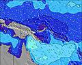 | 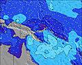 | 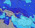 | 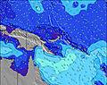 | 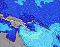 | 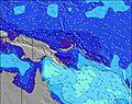 | 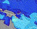 | ||||||||||||
Swell Altura (m) Direção Período (s) | NE 14 | NE 13 | NE 13 | NE 13 | NE 12 | NE 12 | NE 13 | NE 13 | NE 13 | NE 13 | NE 13 | NNE 12 | NNE 15 | NNE 14 | NNE 14 | NNE 13 | NNE 13 | NNE 13 | NNE 13 | NNE 13 |
Onda Gráfico | ||||||||||||||||||||
160 | 140 | 106 | 130 | 92 | 69 | 109 | 113 | 109 | 136 | 134 | 99 | 84 | 178 | 108 | 158 | 158 | 154 | 149 | 129 | |
Vento (km/h) | ||||||||||||||||||||
Estado do Vento maral cruzado-maral Cruzado cruzado-terral terral cristalino | off | off | cross-off | cross | cross-off | off | off | off | off | off | off | off | off | cross-off | off | cross-off | off | off | off | cross-off |
Maré Alta | 6:31PM1.22m | 3:24AM1.14m | 6:04AM1.12m | 7:02PM1.21m | 11:24PM0.90m | 3:46AM1.00m | 7:00AM1.02m | 7:32PM1.20m | ||||||||||||
Maré Baixa | 10:55AM0.49m | 9:52PM0.90m | 4:57AM1.11m | 10:27AM0.60m | 10:28PM0.90m | 1:04AM0.88m | 5:16AM0.97m | 10:23AM0.68m | ||||||||||||
— | — | — | — | — | 6:03 | — | — | — | — | — | — | — | 6:03 | — | — | — | — | — | — | |
— | 6:02 | — | — | — | — | — | — | — | 6:02 | — | — | — | — | — | — | — | 6:02 | — | — | |
mm | — | — | — | — | — | — | — | — | — | — | — | — | — | — | 1 | 4 | 4 | — | — | — |
Temp. °C | 28 | 28 | 27 | 27 | 26 | 27 | 27 | 27 | 27 | 27 | 27 | 27 | 27 | 27 | 27 | 27 | 27 | 26 | 27 | 27 |
Ressent. °C | 28 | 28 | 28 | 28 | 28 | 28 | 28 | 27 | 27 | 27 | 28 | 28 | 29 | 30 | 29 | 28 | 28 | 25 | 27 | 27 |
Swell 1 Altura (m) Direção Período (s) | NE 14 | NE 13 | NE 13 | NE 13 | NE 12 | NE 12 | NE 13 | NE 13 | NE 13 | NE 13 | NE 13 | NNE 12 | NE 12 | NNE 14 | NNE 14 | NNE 13 | NNE 13 | NNE 13 | NNE 13 | NNE 13 |
160 | 140 | 106 | 130 | 92 | 69 | 109 | 113 | 109 | 136 | 134 | 99 | 71 | 178 | 108 | 158 | 158 | 154 | 149 | 129 | |
Swell 2 Altura (m) Direção Período (s) | N 11 | SSW 6 | ESE 8 | ESE 8 | ESE 8 | ESE 8 | ESE 8 | ESE 8 | ENE 15 | ENE 15 | ENE 15 | SSW 6 | ENE 15 | SSW 6 | SSW 6 | SSW 7 | ENE 14 | ENE 13 | ENE 13 | ENE 13 |
9 | 4 | 39 | 22 | 21 | 19 | 21 | 27 | 44 | 42 | 71 | 12 | 71 | 13 | 15 | 17 | 61 | 60 | 60 | 60 | |
Swell 3 Altura (m) Direção Período (s) | ENE 16 | ENE 16 | NE 10 | SSW 6 | ENE 16 | NE 14 | SSW 6 | ENE 16 | ESE 8 | ESE 10 | ESE 10 | ENE 15 | NNE 15 | ENE 14 | NE 12 | ENE 14 | ESE 10 | ESE 10 | ESE 10 | ESE 10 |
25 | 26 | 28 | 7 | 50 | 51 | 8 | 47 | 13 | 18 | 18 | 71 | 84 | 70 | 49 | 66 | 18 | 20 | 20 | 20 | |
Ondas de vento Altura (m) Direção Período (s) | SE 8 | ESE 8 | — | — | — | — | SSE 6 | SSW 6 | S 6 | SSW 3 | SSW 6 | SSW 6 | SSW 6 | — | — | — | SSW 7 | S 4 | S 4 | S 4 |
63 | 46 | — | — | — | — | 11 | 16 | 19 | 9 | 18 | 27 | 10 | — | — | — | 18 | 37 | 38 | 44 | |
Terral ou glassy mais perto | ||||||||||||||||||||
Distância (km) | 0 | 0 | 5 | 838 | 0 | 0 | 0 | 0 | 0 | 0 | 0 | 0 | 0 | 0 | 0 | 5 | 0 | 838 | 0 | 838 |
Melhor previsões de ondas em New Ireland | ||||||||||||||||||||
Melhor previsões de ondas em Papua New Guinea | ||||||||||||||||||||
Buscador de Ondas Global | ||||||||||||||||||||
- Map Icons:
 Break
Break Live Wave Height (m)
 Live Wind Speed (km/h)
 Surf Rating (10 Max)
 Ocean Swells (m)
- Wind Speed (km/h)
widget de graça do Surf-Forecast.com para o seu site
O relatório de surf / widget do tempo abaixo está disponível para incorporar em sites de terceiros gratuitamente e fornece um resumo das nossas Nago surf tempo. Simplesmente pegar o trecho de código html que fornecemos e colá-lo em seu próprio site. Você pode escolher seu idioma preferido e unidades métrico/imperial para o surf tempo de alimentação para atender aos usuários do seu site.... Clique aqui para adquirir o código.
 Nearest