

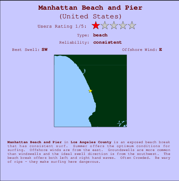
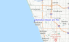
Manhattan Beach and Pier Surf Guide
Manhattan Beach and Pier in LA County is an exposed beach break that has consistent surf. Summer offers the favoured conditions for surfing. The best wind direction is from the east. Most of the surf here comes from groundswells and the ideal swell direction is from the southwest. Waves at the beach are both lefts and rights. Often Crowded. Be wary of rips - they make surfing here dangerous.
Manhattan Beach and Pier Spot Info
| Type: | Rating: | Reliability: | Todays Sea Temp*: |
|---|---|---|---|
| consistent | 22.0°C*ocean temperature recorded from satellite |
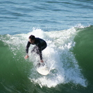
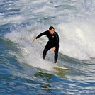
Surfing Manhattan Beach and Pier:
The best conditions reported for surf at Manhattan Beach and Pier occur when a Southwest swell combines with an offshore wind direction from the East.

Previsão da Energia de Ondas (Força): 12hrs


Manhattan Beach and Pier Surf:
Monday, 20 July 2026, 11:56 Local time| Segunda-feira 20 | ||||
| 8AM | 11AM | 2PM | 5PM | |
| Wave (m) | ||||
| Período (s) | 15 | 15 | 16 | 16 |
| Vento (km/h) | ||||
| Estado do Vento | glass | cross | cross- on |
cross- on |
- /breaks/Manhattan-Beach-Pier/forecasts/latest
Manhattan Beach and Pier Surf Guide
Manhattan Beach and Pier in LA County is an exposed beach break that has consistent surf. Summer offers the favoured conditions for surfing. The best wind direction is from the east. Most of the surf here comes from groundswells and the ideal swell direction is from the southwest. Waves at the beach are both lefts and rights. Often Crowded. Be wary of rips - they make surfing here dangerous.
Manhattan Beach and Pier Spot Info
Type: Rating: Reliability: Todays Sea Temp*:  Beach
Beach 1
1consistent 22.0°C*ocean temperature recorded from satelliteSurfing Manhattan Beach and Pier:
The best conditions reported for surf at Manhattan Beach and Pier occur when a Southwest swell combines with an offshore wind direction from the East.
Previsão da Energia de Ondas (Força): 12hrs
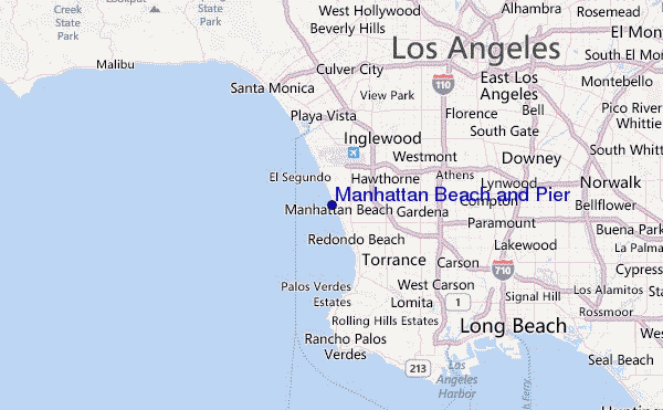
Use a aba navegação acima para ver temperatura do mar em Manhattan Beach and Pier, fotografias de Manhattan Beach and Pier, previsões detalhadas do swell em Manhattan Beach and Pier, previsões do vento e do tempo, webcams em Manhattan Beach and Pier , vento atual em CAL - LA County com base em dados ao vivo fornecidos por estações de meteorologia e previsões da maré em Manhattan Beach and Pier. O link para os mapas do swell em United States abrirá uma imagem ampliada monstrando United States e os mares próximos. Estes mapas do swell podem ser animados para mostrar diferentes componentes do swell, energia das ondas, período das ondas, altura das ondas, assim como previsões do vento e do tempo, observações em tempo real do estado do tempo e do mar graças às bóias de United States, navios passantes e estações de meteorologia presentes na costa. Cada uma das páginas de previsão para este surf break apresenta as ferramentas do buscador global e regional para localizar as melores condições de surf na área ao redor de Manhattan Beach and Pier.
Manhattan Beach and Pier Surf:
Monday, 20 July 2026, 11:56 Local timeSegunda-feira 20 8AM 11AM 2PM 5PM Wave (m) Período (s) 15 15 16 16 Vento (km/h) Estado do Vento glass cross cross-
oncross-
on- /breaks/Manhattan-Beach-Pier/forecasts/latest
- /breaks/Manhattan-Beach-Pier/forecasts/latest/six_day
Manhattan Beach and Pier Surf Guide
Manhattan Beach and Pier in LA County is an exposed beach break that has consistent surf. Summer offers the favoured conditions for surfing. The best wind direction is from the east. Most of the surf here comes from groundswells and the ideal swell direction is from the southwest. Waves at the beach are both lefts and rights. Often Crowded. Be wary of rips - they make surfing here dangerous.
Manhattan Beach and Pier Spot Info
Type: Rating: Reliability: Todays Sea Temp*: Beach1consistent 22.0°C*ocean temperature recorded from satelliteSurfing Manhattan Beach and Pier:
The best conditions reported for surf at Manhattan Beach and Pier occur when a Southwest swell combines with an offshore wind direction from the East.
Previsão da Energia de Ondas (Força): 12hrs
Use a aba navegação acima para ver temperatura do mar em Manhattan Beach and Pier, fotografias de Manhattan Beach and Pier, previsões detalhadas do swell em Manhattan Beach and Pier, previsões do vento e do tempo, webcams em Manhattan Beach and Pier , vento atual em CAL - LA County com base em dados ao vivo fornecidos por estações de meteorologia e previsões da maré em Manhattan Beach and Pier. O link para os mapas do swell em United States abrirá uma imagem ampliada monstrando United States e os mares próximos. Estes mapas do swell podem ser animados para mostrar diferentes componentes do swell, energia das ondas, período das ondas, altura das ondas, assim como previsões do vento e do tempo, observações em tempo real do estado do tempo e do mar graças às bóias de United States, navios passantes e estações de meteorologia presentes na costa. Cada uma das páginas de previsão para este surf break apresenta as ferramentas do buscador global e regional para localizar as melores condições de surf na área ao redor de Manhattan Beach and Pier.
Manhattan Beach and Pier Surf:
Monday, 20 July 2026, 11:56 Local timeSegunda-feira 20 8AM 11AM 2PM 5PM Wave (m) Período (s) 15 15 16 16 Vento (km/h) Estado do Vento glass cross cross-
oncross-
on- /breaks/Manhattan-Beach-Pier/forecasts/latest
Manhattan Beach and Pier Surf Guide
Manhattan Beach and Pier in LA County is an exposed beach break that has consistent surf. Summer offers the favoured conditions for surfing. The best wind direction is from the east. Most of the surf here comes from groundswells and the ideal swell direction is from the southwest. Waves at the beach are both lefts and rights. Often Crowded. Be wary of rips - they make surfing here dangerous.
Manhattan Beach and Pier Spot Info
Type: Rating: Reliability: Todays Sea Temp*: Beach1consistent 22.0°C*ocean temperature recorded from satelliteSurfing Manhattan Beach and Pier:
The best conditions reported for surf at Manhattan Beach and Pier occur when a Southwest swell combines with an offshore wind direction from the East.
Previsão da Energia de Ondas (Força): 12hrs
Use a aba navegação acima para ver temperatura do mar em Manhattan Beach and Pier, fotografias de Manhattan Beach and Pier, previsões detalhadas do swell em Manhattan Beach and Pier, previsões do vento e do tempo, webcams em Manhattan Beach and Pier , vento atual em CAL - LA County com base em dados ao vivo fornecidos por estações de meteorologia e previsões da maré em Manhattan Beach and Pier. O link para os mapas do swell em United States abrirá uma imagem ampliada monstrando United States e os mares próximos. Estes mapas do swell podem ser animados para mostrar diferentes componentes do swell, energia das ondas, período das ondas, altura das ondas, assim como previsões do vento e do tempo, observações em tempo real do estado do tempo e do mar graças às bóias de United States, navios passantes e estações de meteorologia presentes na costa. Cada uma das páginas de previsão para este surf break apresenta as ferramentas do buscador global e regional para localizar as melores condições de surf na área ao redor de Manhattan Beach and Pier.
Manhattan Beach and Pier Surf:
Monday, 20 July 2026, 11:56 Local timeSegunda-feira 20 8AM 11AM 2PM 5PM Wave (m) Período (s) 15 15 16 16 Vento (km/h) Estado do Vento glass cross cross-
oncross-
onTide Times:
Para Manhattan Beach %{dist} %{km} de %{location}
A PRÓXIMA É ÀS (hora local) faltam maré alta maré baixa Manhattan Beach and Pier Tide Times and Tide Chart
Live Weather:
At Los Angeles Airport, 6 km from Manhattan Beach and Pier.
calm
(km/h)
Dry and partly cloudyAir temperature
25.6°CCurrent weather near Manhattan Beach and Pier
Buoy Data:
At Santa Monica Bay, CA, 12 miles from Manhattan Beach and Pier.
6AM 7AM 8AM 9AM Idade dos dados 4 hr 3 hr 2 hr 1 hr Altura de onda (m) 


Período Dominante (s) 10 10 11 10 Overall Manhattan Beach and Pier Surf Consistency and Wind Distribution in Julho


Wind stats for Manhattan Beach and Pier: see the variation in direction and stength by month.
fotos da galeria
Contornos: Estradas & Rios: Escolha um spot de surf da lista 


Use este mapa de relevo para navegar até CAL - LA County surf quebras e estações que estão na área de maré Manhattan Beach and Pier
Outros Spots de Surf mais próximos de Manhattan Beach and Pier:
(Clique no nome do local para maiores detalhes)- Closest spot1 mi
- Second closest spot1 mi
- Third closest spot1 mi
- Fourth closest spot1 mi
- Fifth closest spot2 mi
Bóias ondográficas mais próxima de Manhattan Beach and Pier:
- Closest bóia ondográfica12 mi
- Second closest bóia ondográfica19 mi
- Third closest bóia ondográfica20 mi
- Fourth closest bóia ondográfica25 mi
- Fifth closest bóia ondográfica36 mi
Estações de maré mais próximo de Manhattan Beach and Pier:
- Closest estação de maréManhattan Beach1 mi
- Second closest estação de maréEl Segundo, Santa Monica Bay2 mi
- Third closest estação de maréKing Harbor, Santa Monica Bay3 mi
- Fourth closest estação de maréMarina del Rey6 mi
- Fifth closest estação de maréPalos Verdes Estates7 mi
Airports
- The closest passenger airport to Manhattan Beach and Pier is Los Angeles International Airport (LAX) in USA, 6 km (4 miles) away (directly).
- The second nearest airport to Manhattan Beach and Pier is Jack Northrop Fld Hawthorne Muni Airport (HHR), also in USA, 9 km (6 miles) away.
- Third is Long Beach Airport (LGB) in USA, 26 km (16 miles) away.
- Burbank Glendale Pasadena Airport (BUR) in USA is 35 km (22 miles) away.
- John Wayne Arpt Orange Co (Santa Ana) Airport (SNA), also in USA is the fifth nearest airport to Manhattan Beach and Pier and is 56 km (35 miles) away.
- /breaks/Manhattan-Beach-Pier/forecasts/latest


 Nearest