
Previsão:

Previsão de curto prazoprincipalmente seco. Warm (máx. 24°C na Terça de manhã, mín 19°C na Terça à noite). o vento será geralmente fraco. | |||||||||||||||||||||||
Segunda-feira 27 | Terça-feira 28 | Quarta-feira 29 | |||||||||||||||||||||
4 AM | 7 AM | 10 AM | 1 PM | 4 PM | 7 PM | 10 PM | 1 AM | 4 AM | 7 AM | 10 AM | 1 PM | 4 PM | 7 PM | 10 PM | 1 AM | 4 AM | 7 AM | 10 AM | 1 PM | 4 PM | 7 PM | 10 PM | |
Mapa da altura do Swell |  |  | 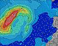 |  | 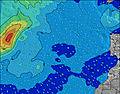 |  |  | 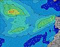 |  | ||||||||||||||
Swell Altura (m) Direção Período (s) | S 11 | S 11 | S 10 | S 10 | S 10 | S 10 | WNW 8 | WNW 8 | WNW 8 | WNW 8 | WNW 12 | WNW 12 | WNW 11 | WNW 11 | WNW 11 | NW 11 | WNW 11 | WNW 10 | NW 10 | NW 10 | NW 10 | WNW 10 | NW 10 |
Onda Gráfico | |||||||||||||||||||||||
9 | 9 | 9 | 8 | 8 | 8 | 7 | 7 | 6 | 6 | 14 | 13 | 12 | 24 | 24 | 30 | 22 | 22 | 27 | 26 | 25 | 38 | 24 | |
Vento (km/h) | |||||||||||||||||||||||
Estado do Vento maral cruzado-maral Cruzado cruzado-terral terral cristalino | off | off | off | cross-off | glassy | cross-off | cross-off | off | off | cross-off | cross-off | cross-off | cross-off | cross-off | glassy | glassy | glassy | cross-off | cross-off | glassy | cross-off | cross-off | cross-off |
Maré Alta | 1:30AM1.67m | 1:47PM1.86m | 2:08AM1.76m | 2:23PM1.97m | 2:42AM1.84m | 2:57PM2.06m | |||||||||||||||||
Maré Baixa | 7:30AM0.50m | 8:02PM0.42m | 8:07AM0.40m | 8:37PM0.33m | 8:40AM0.32m | 9:10PM0.26m | |||||||||||||||||
— | 7:18 | — | — | — | — | — | — | — | 7:18 | — | — | — | — | — | — | — | 7:20 | — | — | — | — | — | |
— | — | — | — | — | 9:09 | — | — | — | — | — | — | — | 9:08 | — | — | — | — | — | — | — | 9:07 | — | |
mm | — | — | — | — | — | — | — | — | — | — | — | — | — | — | — | — | — | — | — | — | — | — | — |
Temp. °C | 20 | 20 | 22 | 23 | 23 | 23 | 21 | 20 | 20 | 20 | 22 | 24 | 23 | 22 | 21 | 20 | 19 | 19 | 22 | 24 | 23 | 23 | 21 |
Ressent. °C | 21 | 21 | 23 | 24 | 25 | 25 | 23 | 21 | 21 | 22 | 24 | 25 | 24 | 24 | 23 | 22 | 21 | 20 | 24 | 26 | 25 | 25 | 23 |
Swell 1 Altura (m) Direção Período (s) | NNE 7 | NNE 7 | NNE 7 | NNE 7 | NNE 7 | NNE 7 | NNE 7 | N 7 | NE 6 | NE 7 | NNE 7 | NNE 7 | NNE 7 | NNE 6 | NNE 6 | NNE 6 | NNE 6 | N 8 | N 7 | N 7 | N 6 | WNW 10 | NW 10 |
75 | 75 | 75 | 62 | 62 | 63 | 49 | 32 | 14 | 24 | 48 | 35 | 25 | 24 | 23 | 24 | 17 | 18 | 16 | 15 | 13 | 38 | 24 | |
Swell 2 Altura (m) Direção Período (s) | WNW 9 | WNW 9 | WNW 9 | WNW 8 | WNW 8 | WNW 8 | NE 8 | NE 7 | WNW 8 | NNW 11 | NNW 11 | NNW 10 | NNW 10 | NNW 10 | NNW 9 | NW 11 | WNW 11 | WNW 10 | NW 10 | NW 10 | NW 10 | N 7 | N 7 |
8 | 8 | 7 | 7 | 7 | 7 | 11 | 25 | 6 | 12 | 22 | 20 | 20 | 18 | 29 | 30 | 22 | 22 | 27 | 26 | 25 | 8 | 8 | |
Swell 3 Altura (m) Direção Período (s) | S 11 | S 11 | S 10 | S 10 | S 10 | S 10 | WNW 8 | WNW 8 | N 11 | WNW 8 | WNW 12 | WNW 12 | WNW 11 | WNW 11 | WNW 11 | N 8 | N 8 | NE 6 | NE 7 | NNE 7 | NE 7 | NNE 6 | NNE 6 |
9 | 9 | 9 | 8 | 8 | 8 | 7 | 7 | 10 | 6 | 14 | 13 | 12 | 24 | 24 | 12 | 12 | 10 | 13 | 5 | 2 | 4 | 4 | |
Ondas de vento Altura (m) Direção Período (s) | — | ENE 6 | ENE 6 | — | — | — | — | — | N 7 | N 7 | N 7 | — | — | — | — | — | — | — | — | — | — | — | — |
— | 33 | 33 | — | — | — | — | — | 35 | 32 | 22 | — | — | — | — | — | — | — | — | — | — | — | — | |
Terral ou glassy mais perto | |||||||||||||||||||||||
Distância (km) | 473 | 473 | 473 | 473 | 473 | 473 | 35 | 35 | 10 | 10 | 10 | 473 | 473 | 10 | 10 | 10 | 16 | 10 | 10 | 10 | 14 | 10 | 20 |
Melhor previsões de ondas em Madeira | |||||||||||||||||||||||
Melhor previsões de ondas em Portugal | |||||||||||||||||||||||
Buscador de Ondas Global | |||||||||||||||||||||||
- Map Icons:
 Break
Break Live Wave Height (m)
 Live Wind Speed (km/h)
 Surf Rating (10 Max)
 Ocean Swells (m)
- Wind Speed (km/h)
widget de graça do Surf-Forecast.com para o seu site
O relatório de surf / widget do tempo abaixo está disponível para incorporar em sites de terceiros gratuitamente e fornece um resumo das nossas Madalena do Mar surf tempo. Simplesmente pegar o trecho de código html que fornecemos e colá-lo em seu próprio site. Você pode escolher seu idioma preferido e unidades métrico/imperial para o surf tempo de alimentação para atender aos usuários do seu site.... Clique aqui para adquirir o código.
 Nearest