
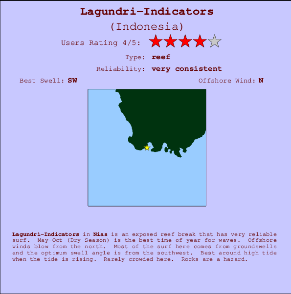
Lagundri-Indicators Surf Guide
Lagundri-Indicators in Nias, Hinako Islands is an exposed reef break that is usually a safe bet. May-Oct (Dry Season) is the optimum time of year for waves. The best wind direction is from the north. Tends to receive distant groundswells and the best swell direction is from the southwest. There is a right breaking reef. Best around high tide when the tide is rising. Unlikely to be too crowded, even when the surf is up. Take care of rocks in the line up.
Lagundri-Indicators Spot Info
| Type: | Rating: | Reliability: | Todays Sea Temp*: |
|---|---|---|---|
| very consistent | 30.1°C*ocean temperature recorded from satellite |
Surfing Lagundri-Indicators:
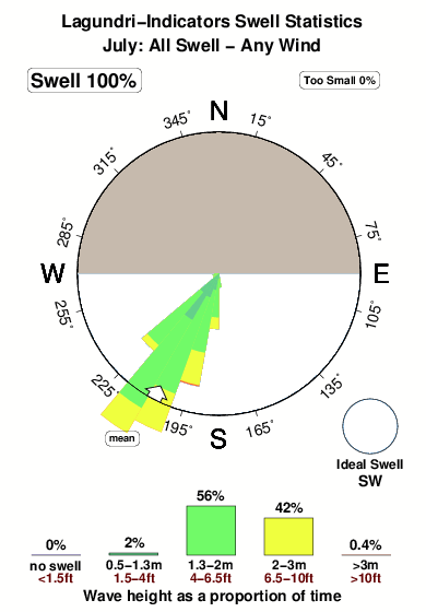
The best conditions reported for surf at Lagundri-Indicators occur when a Southwest swell combines with an offshore wind direction from the North.

Previsão da Energia de Ondas (Força): 12hrs


Lagundri-Indicators Surf:
Saturday, 18 July 2026, 14:19 Local time| Sábado 18 | ||||
| 10AM | 1PM | 4PM | 7PM | |
| Wave (m) | ||||
| Período (s) | 14 | 14 | 14 | 14 |
| Vento (km/h) | ||||
| Estado do Vento | cross- off |
cross- off |
glass | cross- off |
- /breaks/Lagundri-Indicators/forecasts/latest
Lagundri-Indicators Surf Guide
Lagundri-Indicators in Nias, Hinako Islands is an exposed reef break that is usually a safe bet. May-Oct (Dry Season) is the optimum time of year for waves. The best wind direction is from the north. Tends to receive distant groundswells and the best swell direction is from the southwest. There is a right breaking reef. Best around high tide when the tide is rising. Unlikely to be too crowded, even when the surf is up. Take care of rocks in the line up.
Lagundri-Indicators Spot Info
Type: Rating: Reliability: Todays Sea Temp*:  Reef
Reef 4
4very consistent 30.1°C*ocean temperature recorded from satelliteSurfing Lagundri-Indicators:
The best conditions reported for surf at Lagundri-Indicators occur when a Southwest swell combines with an offshore wind direction from the North.
Previsão da Energia de Ondas (Força): 12hrs
Use a aba navegação acima para ver temperatura do mar em Lagundri-Indicators, fotografias de Lagundri-Indicators, previsões detalhadas do swell em Lagundri-Indicators, previsões do vento e do tempo, webcams em Lagundri-Indicators , vento atual em Nias com base em dados ao vivo fornecidos por estações de meteorologia e previsões da maré em Lagundri-Indicators. O link para os mapas do swell em Indonesia abrirá uma imagem ampliada monstrando Indonesia e os mares próximos. Estes mapas do swell podem ser animados para mostrar diferentes componentes do swell, energia das ondas, período das ondas, altura das ondas, assim como previsões do vento e do tempo, observações em tempo real do estado do tempo e do mar graças às bóias de Indonesia, navios passantes e estações de meteorologia presentes na costa. Cada uma das páginas de previsão para este surf break apresenta as ferramentas do buscador global e regional para localizar as melores condições de surf na área ao redor de Lagundri-Indicators.
Lagundri-Indicators Surf:
Saturday, 18 July 2026, 14:19 Local timeSábado 18 10AM 1PM 4PM 7PM Wave (m) Período (s) 14 14 14 14 Vento (km/h) Estado do Vento cross-
offcross-
offglass cross-
off- /breaks/Lagundri-Indicators/forecasts/latest
- /breaks/Lagundri-Indicators/forecasts/latest/six_day
Lagundri-Indicators Surf Guide
Lagundri-Indicators in Nias, Hinako Islands is an exposed reef break that is usually a safe bet. May-Oct (Dry Season) is the optimum time of year for waves. The best wind direction is from the north. Tends to receive distant groundswells and the best swell direction is from the southwest. There is a right breaking reef. Best around high tide when the tide is rising. Unlikely to be too crowded, even when the surf is up. Take care of rocks in the line up.
Lagundri-Indicators Spot Info
Type: Rating: Reliability: Todays Sea Temp*: Reef4very consistent 30.1°C*ocean temperature recorded from satelliteSurfing Lagundri-Indicators:
The best conditions reported for surf at Lagundri-Indicators occur when a Southwest swell combines with an offshore wind direction from the North.
Previsão da Energia de Ondas (Força): 12hrs
Use a aba navegação acima para ver temperatura do mar em Lagundri-Indicators, fotografias de Lagundri-Indicators, previsões detalhadas do swell em Lagundri-Indicators, previsões do vento e do tempo, webcams em Lagundri-Indicators , vento atual em Nias com base em dados ao vivo fornecidos por estações de meteorologia e previsões da maré em Lagundri-Indicators. O link para os mapas do swell em Indonesia abrirá uma imagem ampliada monstrando Indonesia e os mares próximos. Estes mapas do swell podem ser animados para mostrar diferentes componentes do swell, energia das ondas, período das ondas, altura das ondas, assim como previsões do vento e do tempo, observações em tempo real do estado do tempo e do mar graças às bóias de Indonesia, navios passantes e estações de meteorologia presentes na costa. Cada uma das páginas de previsão para este surf break apresenta as ferramentas do buscador global e regional para localizar as melores condições de surf na área ao redor de Lagundri-Indicators.
Lagundri-Indicators Surf:
Saturday, 18 July 2026, 14:19 Local timeSábado 18 10AM 1PM 4PM 7PM Wave (m) Período (s) 14 14 14 14 Vento (km/h) Estado do Vento cross-
offcross-
offglass cross-
off- /breaks/Lagundri-Indicators/forecasts/latest
Lagundri-Indicators Surf Guide
Lagundri-Indicators in Nias, Hinako Islands is an exposed reef break that is usually a safe bet. May-Oct (Dry Season) is the optimum time of year for waves. The best wind direction is from the north. Tends to receive distant groundswells and the best swell direction is from the southwest. There is a right breaking reef. Best around high tide when the tide is rising. Unlikely to be too crowded, even when the surf is up. Take care of rocks in the line up.
Lagundri-Indicators Spot Info
Type: Rating: Reliability: Todays Sea Temp*: Reef4very consistent 30.1°C*ocean temperature recorded from satelliteSurfing Lagundri-Indicators:
The best conditions reported for surf at Lagundri-Indicators occur when a Southwest swell combines with an offshore wind direction from the North.
Previsão da Energia de Ondas (Força): 12hrs
Use a aba navegação acima para ver temperatura do mar em Lagundri-Indicators, fotografias de Lagundri-Indicators, previsões detalhadas do swell em Lagundri-Indicators, previsões do vento e do tempo, webcams em Lagundri-Indicators , vento atual em Nias com base em dados ao vivo fornecidos por estações de meteorologia e previsões da maré em Lagundri-Indicators. O link para os mapas do swell em Indonesia abrirá uma imagem ampliada monstrando Indonesia e os mares próximos. Estes mapas do swell podem ser animados para mostrar diferentes componentes do swell, energia das ondas, período das ondas, altura das ondas, assim como previsões do vento e do tempo, observações em tempo real do estado do tempo e do mar graças às bóias de Indonesia, navios passantes e estações de meteorologia presentes na costa. Cada uma das páginas de previsão para este surf break apresenta as ferramentas do buscador global e regional para localizar as melores condições de surf na área ao redor de Lagundri-Indicators.
Lagundri-Indicators Surf:
Saturday, 18 July 2026, 14:19 Local timeSábado 18 10AM 1PM 4PM 7PM Wave (m) Período (s) 14 14 14 14 Vento (km/h) Estado do Vento cross-
offcross-
offglass cross-
offTide Times:
Em Lagundri-Indicators (0 km).
A PRÓXIMA É ÀS (hora local) faltam maré alta maré baixa Lagundri-Indicators Tide Times and Tide Chart
Live Weather:
At Minangkabau Airport, 323 km from Lagundri-Indicators.
wind obs. (6 kph from 1 degs) was rejected
(km/h)
Dry and partly cloudyAir temperature
29°COverall Lagundri-Indicators Surf Consistency and Wind Distribution in Julho
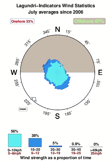


Wind stats for Lagundri-Indicators: see the variation in direction and stength by month.
fotos da galeria
Contornos: Estradas & Rios: Escolha um spot de surf da lista 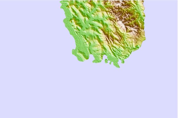
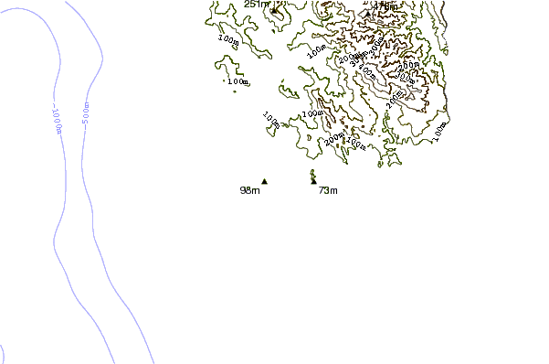
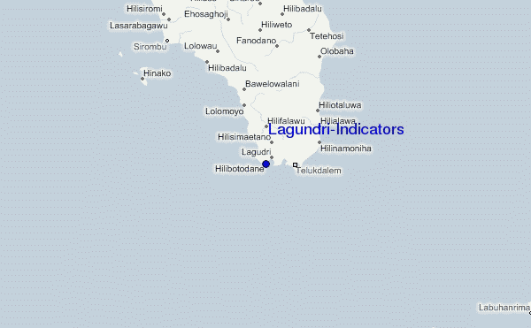
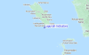
Use este mapa de relevo para navegar até Nias surf quebras e estações que estão na área de maré Lagundri-Indicators
Outros Spots de Surf mais próximos de Lagundri-Indicators:
(Clique no nome do local para maiores detalhes)- Closest spot1 mi
- Second closest spot1 mi
- Third closest spot7 mi
- Fourth closest spot9 mi
- Fifth closest spot12 mi
Bóias ondográficas mais próxima de Lagundri-Indicators:
- Closest bóia ondográfica2414 mi
- Second closest bóia ondográfica2491 mi
- Third closest bóia ondográfica2669 mi
- Fourth closest bóia ondográfica2684 mi
- Fifth closest bóia ondográfica2853 mi
Estações de maré mais próximo de Lagundri-Indicators:
- Closest estação de maréSibolga109 mi
- Second closest estação de maréSinabang161 mi
- Third closest estação de maréPariaman185 mi
- Fourth closest estação de maréTeluk Nibung222 mi
- Fifth closest estação de maréBelawan236 mi
Airports
- The nearest passenger airport to Lagundri-Indicators is Binaka (Gunung Sitoli) Airport (GNS) in Indonesia, which is 66 km (41 miles) away (directly).
- The second closest airport to Lagundri-Indicators is Tabing (Padang) Airport (PDG), also in Indonesia, 334 km (207 miles) away.
- /breaks/Lagundri-Indicators/forecasts/latest
 Nearest