
Previsão:

Previsão de curto prazoChuva intensa (total 35mm), mais intensa durante Sexta à noite. Very mild (máx. 19°C na Sexta de noite, mín 10°C na Quarta à tarde). Ventos diminuem (ventos frescos de Nordeste na Sexta de manhã, vento fraco de Norte na Sex à noite). | ||||||||||||||||||||
Quar 29 | Quinta-feira 30 | Sexta-feira 31 | ||||||||||||||||||
12 PM | 3 PM | 6 PM | 9 PM | 12 AM | 3 AM | 6 AM | 9 AM | 12 PM | 3 PM | 6 PM | 9 PM | 12 AM | 3 AM | 6 AM | 9 AM | 12 PM | 3 PM | 6 PM | 9 PM | |
Mapa da altura do Swell |  | 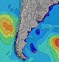 |  |  |  |  |  | 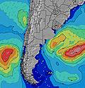 | ||||||||||||
Swell Altura (m) Direção Período (s) | S 5 | SSE 8 | SSE 8 | SSE 8 | SSE 8 | SSE 8 | SSE 13 | SSE 13 | SSE 12 | SSE 12 | SSE 11 | SSE 11 | SSE 11 | S 11 | ENE 6 | SSE 10 | SSE 10 | SSE 9 | SSE 9 | SSE 9 |
Onda Gráfico | ||||||||||||||||||||
24 | 23 | 22 | 65 | 60 | 44 | 63 | 64 | 155 | 145 | 133 | 123 | 91 | 90 | 119 | 32 | 31 | 17 | 17 | 16 | |
Vento (km/h) | ||||||||||||||||||||
Estado do Vento maral cruzado-maral Cruzado cruzado-terral terral cristalino | cross-on | cross-on | cross-on | on | cross-on | on | on | cross-on | cross-on | cross-on | cross-on | cross-on | cross-on | cross | cross | cross | cross | cross | cross | cross |
Maré Alta | 1:18PM0.25m | 7:03PM0.39m | 00:35AM0.20m | 7:39AM0.23m | 1:53PM0.25m | 7:47PM0.38m | 1:23AM0.20m | 8:21AM0.25m | 2:30PM0.25m | 8:31PM0.38m | ||||||||||
Maré Baixa | 9:52AM0.13m | 3:20PM0.22m | 11:08PM0.18m | 4:08AM0.07m | 10:36AM0.13m | 4:08PM0.21m | 11:43PM0.18m | 4:49AM0.07m | 11:21AM0.13m | 4:53PM0.19m | ||||||||||
— | — | — | — | — | — | 7:31 | — | — | — | — | — | — | — | 7:31 | — | — | — | — | — | |
— | 5:52 | — | — | — | — | — | — | — | 5:53 | — | — | — | — | — | — | — | 5:53 | — | — | |
mm | — | — | — | — | — | — | — | — | — | — | — | — | — | — | — | — | — | — | 1 | 1 |
Temp. °C | 11 | 11 | 10 | 10 | 10 | 10 | 10 | 10 | 12 | 12 | 12 | 12 | 12 | 12 | 12 | 13 | 15 | 18 | 17 | 17 |
Ressent. °C | 7 | 8 | 7 | 7 | 8 | 8 | 8 | 8 | 8 | 8 | 8 | 7 | 6 | 6 | 6 | 7 | 9 | 14 | 14 | 13 |
Swell 1 Altura (m) Direção Período (s) | SSE 8 | S 5 | S 5 | SSE 8 | SSE 8 | SSE 8 | SSE 7 | SSE 7 | SSE 12 | SSE 12 | SSE 11 | SSE 11 | SSE 11 | S 11 | S 10 | SSE 10 | SSE 10 | SSE 9 | SSE 9 | SSE 9 |
24 | 17 | 20 | 65 | 60 | 44 | 43 | 42 | 155 | 145 | 133 | 123 | 91 | 82 | 51 | 32 | 31 | 17 | 17 | 16 | |
Swell 2 Altura (m) Direção Período (s) | E 8 | SSE 8 | SSE 8 | E 8 | SSE 14 | SSE 13 | SSE 13 | SSE 13 | E 8 | SE 8 | SSW 6 | SE 5 | S 7 | SE 8 | S 7 | S 7 | SE 7 | — | S 9 | — |
18 | 23 | 22 | 11 | 36 | 35 | 63 | 64 | 5 | 15 | 4 | 1 | 27 | 2 | 3 | 3 | 2 | — | 1 | — | |
Swell 3 Altura (m) Direção Período (s) | S 12 | E 8 | E 8 | SSE 14 | E 8 | E 8 | E 8 | E 8 | E 8 | NE 7 | — | — | — | SE 9 | SE 8 | SE 7 | SE 8 | — | — | — |
3 | 19 | 10 | 20 | 11 | 11 | 5 | 5 | 5 | 7 | — | — | — | 3 | 2 | 2 | 3 | — | — | — | |
Ondas de vento Altura (m) Direção Período (s) | S 5 | — | — | — | — | — | — | — | E 2 | E 3 | ENE 4 | ENE 4 | ENE 5 | ENE 5 | ENE 6 | ENE 6 | ENE 7 | ENE 7 | ENE 8 | ENE 8 |
21 | — | — | — | — | — | — | — | 1 | 8 | 25 | 33 | 50 | 90 | 119 | 175 | 237 | 261 | 291 | 336 | |
Terral ou glassy mais perto | ||||||||||||||||||||
Distância (km) | 349 | 374 | 374 | 37 | 86 | 37 | 8 | 7 | 37 | 37 | 37 | 79 | 864 | 709 | 709 | 601 | 995 | 1050 | 629 | 349 |
Melhor previsões de ondas em Uruguay - North | ||||||||||||||||||||
Melhor previsões de ondas em Uruguay | ||||||||||||||||||||
Buscador de Ondas Global | ||||||||||||||||||||
- Map Icons:
 Break
Break Live Wave Height (m)
 Live Wind Speed (km/h)
 Surf Rating (10 Max)
 Ocean Swells (m)
- Wind Speed (km/h)
widget de graça do Surf-Forecast.com para o seu site
O relatório de surf / widget do tempo abaixo está disponível para incorporar em sites de terceiros gratuitamente e fornece um resumo das nossas La Derecha del Medio surf tempo. Simplesmente pegar o trecho de código html que fornecemos e colá-lo em seu próprio site. Você pode escolher seu idioma preferido e unidades métrico/imperial para o surf tempo de alimentação para atender aos usuários do seu site.... Clique aqui para adquirir o código.
 Nearest