
Previsão:

Previsão de curto prazoprincipalmente seco. Warm (máx. 23°C na Segunda de manhã, mín 21°C na Seg à noite). principalmente ventos frescos. | |||||||||||||||||||||
Seg 3 | Terça-feira 4 | Quarta-feira 5 | |||||||||||||||||||
10 AM | 1 PM | 4 PM | 7 PM | 10 PM | 1 AM | 4 AM | 7 AM | 10 AM | 1 PM | 4 PM | 7 PM | 10 PM | 1 AM | 4 AM | 7 AM | 10 AM | 1 PM | 4 PM | 7 PM | 10 PM | |
Mapa da altura do Swell |  |  |  | 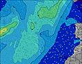 |  |  | 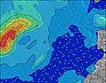 | 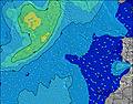 | |||||||||||||
Swell Altura (m) Direção Período (s) | NNE 7 | NNE 7 | NNE 7 | NNE 7 | NNE 6 | NNE 6 | NNE 6 | NNE 7 | NE 7 | NE 7 | NE 7 | NE 7 | NNE 7 | NNE 7 | NE 7 | NE 7 | NE 8 | NE 8 | NE 8 | NE 8 | NE 7 |
Onda Gráfico | |||||||||||||||||||||
237 | 222 | 192 | 170 | 170 | 170 | 239 | 277 | 312 | 321 | 276 | 227 | 261 | 304 | 404 | 479 | 499 | 481 | 446 | 446 | 429 | |
Vento (km/h) | |||||||||||||||||||||
Estado do Vento maral cruzado-maral Cruzado cruzado-terral terral cristalino | on | cross-on | cross-on | on | on | cross-on | cross-on | cross-on | on | cross-on | on | on | on | on | cross-on | cross-on | cross-on | cross-on | cross-on | on | on |
Maré Alta | 5:18PM2.28m | 5:43AM2.07m | 5:59PM2.16m | 6:30AM1.98m | 6:50PM2.01m | ||||||||||||||||
Maré Baixa | 11:01AM0.36m | 11:30PM0.32m | 11:41AM0.44m | 00:13AM0.42m | 12:30PM0.55m | ||||||||||||||||
7:15 | — | — | — | — | — | — | 7:16 | — | — | — | — | — | — | — | 7:16 | — | — | — | — | — | |
— | — | — | 8:44 | — | — | — | — | — | — | — | 8:44 | — | — | — | — | — | — | — | 8:43 | — | |
mm | — | — | — | — | — | — | — | — | — | — | — | — | — | — | — | — | — | — | — | — | — |
Temp. °C | 23 | 23 | 23 | 23 | 21 | 21 | 21 | 21 | 22 | 23 | 23 | 23 | 21 | 21 | 21 | 21 | 22 | 22 | 22 | 22 | 21 |
Ressent. °C | 20 | 21 | 21 | 21 | 19 | 19 | 18 | 20 | 20 | 21 | 21 | 21 | 18 | 18 | 18 | 18 | 18 | 18 | 19 | 19 | 18 |
Swell 1 Altura (m) Direção Período (s) | WNW 9 | WNW 9 | WNW 9 | WNW 9 | WNW 9 | WNW 9 | WNW 9 | WNW 9 | WNW 9 | WNW 9 | WNW 9 | WNW 9 | NW 8 | WNW 8 | WNW 8 | NW 10 | NW 8 | NW 8 | WNW 8 | WNW 11 | WNW 10 |
48 | 47 | 32 | 32 | 32 | 33 | 33 | 33 | 32 | 32 | 30 | 29 | 35 | 47 | 26 | 25 | 16 | 17 | 40 | 75 | 63 | |
Swell 2 Altura (m) Direção Período (s) | — | N 9 | N 9 | N 8 | NW 9 | N 8 | NW 10 | NW 9 | N 8 | — | NW 11 | WNW 11 | WNW 11 | WNW 11 | WNW 10 | NW 8 | NW 10 | WNW 10 | N 12 | NNW 12 | NNW 11 |
— | 14 | 24 | 23 | 3 | 12 | 4 | 3 | 5 | — | 5 | 12 | 12 | 12 | 20 | 16 | 26 | 20 | 11 | 14 | 25 | |
Swell 3 Altura (m) Direção Período (s) | — | NW 9 | NW 11 | — | — | — | — | — | — | — | — | — | — | — | — | — | N 11 | N 11 | N 11 | N 11 | N 11 |
— | 3 | 5 | — | — | — | — | — | — | — | — | — | — | — | — | — | 2 | 2 | 2 | 2 | 2 | |
Ondas de vento Altura (m) Direção Período (s) | NNE 7 | NNE 7 | NNE 7 | NNE 7 | NNE 6 | NNE 6 | NNE 6 | NNE 7 | NE 7 | NE 7 | NE 7 | NE 7 | NNE 7 | NNE 7 | NE 7 | NE 7 | NE 8 | NE 8 | NE 8 | NE 8 | NE 7 |
237 | 222 | 192 | 170 | 170 | 170 | 239 | 277 | 312 | 321 | 276 | 227 | 261 | 304 | 404 | 479 | 499 | 481 | 446 | 446 | 429 | |
Terral ou glassy mais perto | |||||||||||||||||||||
Distância (km) | 38 | 38 | 38 | 38 | 259 | 38 | 277 | 259 | 277 | 38 | 38 | 38 | 259 | 259 | 259 | 259 | 259 | 259 | 331 | 259 | 259 |
Melhor previsões de ondas em Lanzarote | |||||||||||||||||||||
Melhor previsões de ondas em Spain (Africa) | |||||||||||||||||||||
Buscador de Ondas Global | |||||||||||||||||||||
- Map Icons:
 Break
Break Live Wave Height (m)
 Live Wind Speed (km/h)
 Surf Rating (10 Max)
 Ocean Swells (m)
- Wind Speed (km/h)
widget de graça do Surf-Forecast.com para o seu site
O relatório de surf / widget do tempo abaixo está disponível para incorporar em sites de terceiros gratuitamente e fornece um resumo das nossas La Caleta surf tempo. Simplesmente pegar o trecho de código html que fornecemos e colá-lo em seu próprio site. Você pode escolher seu idioma preferido e unidades métrico/imperial para o surf tempo de alimentação para atender aos usuários do seu site.... Clique aqui para adquirir o código.
 Nearest