
Previsão:

Previsão de curto prazochuviscos (total 5mm), principalmente caindo na Segunda à tarde. Warm (máx. 28°C no Sábado de manhã, mín 27°C na Seg à noite). o vento será geralmente fraco. | ||||||||||||||||||||||||
Sábado 25 | Domingo 26 | Segunda-feira 27 | ||||||||||||||||||||||
2 AM | 5 AM | 8 AM | 11 AM | 2 PM | 5 PM | 8 PM | 11 PM | 2 AM | 5 AM | 8 AM | 11 AM | 2 PM | 5 PM | 8 PM | 11 PM | 2 AM | 5 AM | 8 AM | 11 AM | 2 PM | 5 PM | 8 PM | 11 PM | |
Mapa da altura do Swell |  | 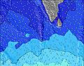 | 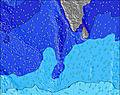 | 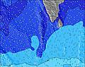 | 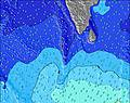 |  | 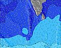 | 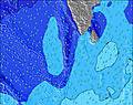 | 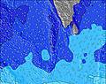 | |||||||||||||||
Swell Altura (m) Direção Período (s) | SE 9 | SE 9 | SE 10 | SE 10 | SE 10 | SE 10 | SE 10 | SE 10 | SE 10 | SE 10 | SE 11 | SE 11 | SE 11 | SE 11 | SE 10 | SE 10 | SE 10 | SE 10 | SE 10 | SE 10 | SE 10 | SE 10 | SE 10 | SW 15 |
Onda Gráfico | ||||||||||||||||||||||||
321 | 335 | 416 | 442 | 484 | 475 | 475 | 475 | 520 | 562 | 568 | 568 | 558 | 505 | 486 | 468 | 468 | 477 | 433 | 377 | 370 | 370 | 396 | 355 | |
Vento (km/h) | ||||||||||||||||||||||||
Estado do Vento maral cruzado-maral Cruzado cruzado-terral terral cristalino | cross-on | glassy | cross-on | on | cross-on | on | on | on | on | glassy | glassy | glassy | glassy | glassy | glassy | cross | cross | cross | cross | cross | cross | cross | cross | cross |
Maré Alta | 11:54AM0.76m | 10:51PM0.59m | 12:35PM0.82m | 11:56PM0.64m | 1:07PM0.89m | |||||||||||||||||||
Maré Baixa | 4:05AM0.31m | 6:39PM0.50m | 5:21AM0.26m | 7:03PM0.43m | 6:10AM0.20m | 7:25PM0.37m | ||||||||||||||||||
— | 6:07 | — | — | — | — | — | — | — | 6:07 | — | — | — | — | — | — | — | 6:07 | — | — | — | — | — | — | |
— | — | — | — | — | 6:16 | — | — | — | — | — | — | — | 6:16 | — | — | — | — | — | — | — | 6:16 | — | — | |
mm | 1 | 3 | — | — | — | — | — | — | — | — | — | — | — | — | — | — | — | — | — | — | 1 | 1 | 1 | 1 |
Temp. °C | 28 | 28 | 28 | 28 | 28 | 28 | 28 | 28 | 28 | 28 | 28 | 28 | 28 | 28 | 28 | 28 | 28 | 28 | 28 | 28 | 28 | 28 | 28 | 27 |
Ressent. °C | 32 | 32 | 32 | 32 | 31 | 31 | 31 | 31 | 32 | 32 | 32 | 32 | 32 | 32 | 32 | 31 | 31 | 31 | 32 | 30 | 30 | 30 | 30 | 29 |
Swell 1 Altura (m) Direção Período (s) | SE 9 | SE 9 | SE 10 | SE 10 | SE 10 | SE 10 | SE 10 | SE 10 | SE 10 | SE 10 | SE 11 | SE 11 | SE 11 | SE 11 | SE 10 | SE 10 | SE 10 | SE 10 | SE 10 | SE 10 | SE 10 | SE 10 | SE 10 | SE 10 |
321 | 335 | 416 | 442 | 484 | 475 | 475 | 475 | 520 | 562 | 568 | 568 | 558 | 505 | 486 | 468 | 468 | 477 | 433 | 377 | 370 | 370 | 396 | 355 | |
Swell 2 Altura (m) Direção Período (s) | SSW 15 | SSW 14 | SSW 14 | SSW 15 | SSW 12 | SSW 14 | SSW 14 | SSW 13 | SW 13 | SSW 13 | SSW 13 | SSW 13 | SSW 13 | SSW 12 | SSW 12 | NW 10 | NW 10 | WNW 10 | NW 10 | NW 9 | NW 9 | SW 15 | SW 15 | SW 15 |
242 | 183 | 186 | 188 | 121 | 357 | 236 | 229 | 180 | 273 | 273 | 273 | 299 | 237 | 193 | 124 | 104 | 125 | 96 | 88 | 84 | 217 | 217 | 314 | |
Swell 3 Altura (m) Direção Período (s) | SW 12 | SW 12 | SW 12 | SSW 12 | SSW 14 | NW 11 | SSW 11 | SSW 11 | NW 10 | NW 10 | NW 10 | NW 10 | NW 10 | NW 10 | NW 10 | SSW 12 | SSW 12 | SSW 12 | SSW 12 | SSW 12 | SW 15 | NW 9 | NW 9 | WNW 10 |
120 | 69 | 69 | 79 | 186 | 42 | 79 | 79 | 65 | 69 | 87 | 108 | 108 | 127 | 124 | 167 | 167 | 129 | 127 | 127 | 217 | 81 | 75 | 85 | |
Ondas de vento Altura (m) Direção Período (s) | — | — | — | — | — | — | — | — | — | — | — | — | — | — | — | — | — | — | — | — | — | — | — | S 6 |
— | — | — | — | — | — | — | — | — | — | — | — | — | — | — | — | — | — | — | — | — | — | — | 37 | |
Terral ou glassy mais perto | ||||||||||||||||||||||||
Distância (km) | 44 | 0 | 57 | 57 | 57 | 57 | 57 | 57 | 57 | 0 | 0 | 0 | 0 | 0 | 0 | 118 | 118 | 118 | 144 | 118 | 118 | 118 | 146 | 1162 |
Melhor previsões de ondas em Huvadhoo Atoll | ||||||||||||||||||||||||
Melhor previsões de ondas em Maldives | ||||||||||||||||||||||||
Buscador de Ondas Global | ||||||||||||||||||||||||
- Map Icons:
 Break
Break Live Wave Height (m)
 Live Wind Speed (km/h)
 Surf Rating (10 Max)
 Ocean Swells (m)
- Wind Speed (km/h)
widget de graça do Surf-Forecast.com para o seu site
O relatório de surf / widget do tempo abaixo está disponível para incorporar em sites de terceiros gratuitamente e fornece um resumo das nossas Koodhoo surf tempo. Simplesmente pegar o trecho de código html que fornecemos e colá-lo em seu próprio site. Você pode escolher seu idioma preferido e unidades métrico/imperial para o surf tempo de alimentação para atender aos usuários do seu site.... Clique aqui para adquirir o código.
 Nearest