
Previsão:

Previsão de curto prazochuva moderada (total 12mm), mais intensa na Terça à tarde. Warm (máx. 30°C na Segunda à tarde, mín 29°C na Segunda à tarde). Ventos aumentam (vento fraco de Este-Nordeste na Terça de manhã, near gales de Norte na Quinta de manhã). | ||||||||||||||||||||
Seg 3 | Terça-feira 4 | Quarta-feira 5 | ||||||||||||||||||
12 PM | 3 PM | 6 PM | 9 PM | 12 AM | 3 AM | 6 AM | 9 AM | 12 PM | 3 PM | 6 PM | 9 PM | 12 AM | 3 AM | 6 AM | 9 AM | 12 PM | 3 PM | 6 PM | 9 PM | |
Mapa da altura do Swell |  |  |  | 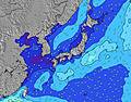 |  |  | 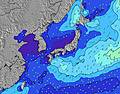 |  | ||||||||||||
Swell Altura (m) Direção Período (s) | E 16 | E 16 | E 16 | E 16 | E 16 | E 16 | E 17 | E 17 | E 17 | E 17 | E 17 | E 17 | E 17 | E 17 | E 17 | E 17 | E 17 | E 18 | E 18 | E 18 |
Onda Gráfico | ||||||||||||||||||||
1106 | 1474 | 1438 | 1452 | 1626 | 1652 | 2594 | 2873 | 2840 | 3104 | 3710 | 4328 | 4935 | 4771 | 5451 | 5575 | 6391 | 10425 | 14796 | 17296 | |
Vento (km/h) | ||||||||||||||||||||
Estado do Vento maral cruzado-maral Cruzado cruzado-terral terral cristalino | cross-on | cross-on | cross-on | cross-on | cross-on | on | on | on | on | on | on | cross-on | on | on | on | on | on | on | on | on |
Maré Alta | 10:00PM1.76m | 10:14AM1.62m | 10:32PM1.73m | 11:10AM1.50m | ||||||||||||||||
Maré Baixa | 3:40PM0.44m | 4:10AM0.57m | 4:14PM0.59m | 4:58AM0.55m | 4:53PM0.76m | |||||||||||||||
— | — | — | — | — | 5:52 | — | — | — | — | — | — | — | 5:52 | — | — | — | — | — | — | |
— | — | 7:14 | — | — | — | — | — | — | — | 7:13 | — | — | — | — | — | — | — | 7:12 | — | |
mm | — | — | — | — | 1 | — | — | — | 1 | 2 | 1 | 1 | 1 | — | 1 | 1 | — | — | 1 | — |
Temp. °C | 29 | 29 | 30 | 29 | 29 | 29 | 29 | 30 | 29 | 30 | 30 | 29 | 29 | 29 | 29 | 29 | 30 | 30 | 29 | 29 |
Ressent. °C | 32 | 31 | 32 | 31 | 30 | 30 | 30 | 32 | 31 | 32 | 32 | 31 | 30 | 30 | 31 | 29 | 31 | 30 | 29 | 29 |
Swell 1 Altura (m) Direção Período (s) | E 16 | E 16 | E 16 | E 16 | E 16 | E 16 | E 17 | E 17 | E 17 | E 17 | E 17 | E 17 | E 17 | E 17 | E 17 | E 17 | E 17 | E 18 | E 18 | E 18 |
1106 | 1474 | 1438 | 1452 | 1626 | 1652 | 2594 | 2873 | 2840 | 3104 | 3710 | 4328 | 4935 | 4771 | 5451 | 5575 | 6391 | 10425 | 14796 | 17296 | |
Swell 2 Altura (m) Direção Período (s) | S 7 | S 7 | S 7 | SE 14 | S 7 | S 7 | SE 14 | — | — | — | — | — | — | — | S 8 | S 8 | S 8 | SSW 7 | — | — |
4 | 4 | 9 | 33 | 9 | 9 | 8 | — | — | — | — | — | — | — | 18 | 18 | 18 | 18 | — | — | |
Swell 3 Altura (m) Direção Período (s) | SE 8 | SE 14 | SE 14 | S 7 | SE 8 | SE 8 | — | — | — | — | — | — | — | — | NE 8 | — | — | — | — | — |
11 | 8 | 8 | 4 | 11 | 3 | — | — | — | — | — | — | — | — | 10 | — | — | — | — | — | |
Ondas de vento Altura (m) Direção Período (s) | N 4 | W 7 | N 4 | N 4 | N 4 | NNE 4 | SE 8 | NE 4 | SE 8 | SE 8 | — | — | — | NE 5 | NE 6 | NE 6 | NE 6 | — | — | — |
9 | 4 | 10 | 9 | 11 | 14 | 23 | 29 | 21 | 23 | — | — | — | 53 | 50 | 64 | 124 | — | — | — | |
Terral ou glassy mais perto | ||||||||||||||||||||
Distância (km) | 46 | 41 | 88 | 41 | 41 | 46 | 46 | 46 | 46 | 46 | 46 | 46 | 46 | 46 | 46 | 46 | 869 | 747 | 675 | 675 |
Melhor previsões de ondas em Okinawa | ||||||||||||||||||||
Melhor previsões de ondas em Japan | ||||||||||||||||||||
Buscador de Ondas Global | ||||||||||||||||||||
- Map Icons:
 Break
Break Live Wave Height (m)
 Live Wind Speed (km/h)
 Surf Rating (10 Max)
 Ocean Swells (m)
- Wind Speed (km/h)
widget de graça do Surf-Forecast.com para o seu site
O relatório de surf / widget do tempo abaixo está disponível para incorporar em sites de terceiros gratuitamente e fornece um resumo das nossas Ko-Chan (Hedo Point) surf tempo. Simplesmente pegar o trecho de código html que fornecemos e colá-lo em seu próprio site. Você pode escolher seu idioma preferido e unidades métrico/imperial para o surf tempo de alimentação para atender aos usuários do seu site.... Clique aqui para adquirir o código.
 Nearest