
Previsão:

Previsão de curto prazochuva moderada (total 16mm), mais intensa no Domingo à noite. Warm (máx. 20°C na Segunda à tarde, mín 13°C na Terça à noite). Ventos aumentam (vento fraco de Sudeste na Segunda à tarde, near gales de Oeste-Noroeste na Quarta de manhã). | ||||||||||||||||||||||||
Segunda-feira 3 | Terça-feira 4 | Quarta-feira 5 | ||||||||||||||||||||||
1 AM | 4 AM | 7 AM | 10 AM | 1 PM | 4 PM | 7 PM | 10 PM | 1 AM | 4 AM | 7 AM | 10 AM | 1 PM | 4 PM | 7 PM | 10 PM | 1 AM | 4 AM | 7 AM | 10 AM | 1 PM | 4 PM | 7 PM | 10 PM | |
Mapa da altura do Swell |  | 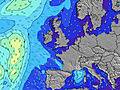 |  |  |  |  |  |  |  | |||||||||||||||
Swell Altura (m) Direção Período (s) | SW 9 | SW 9 | SW 9 | SW 9 | SW 9 | SSW 8 | SSW 8 | SSW 8 | SSW 8 | SSW 7 | SSW 7 | SSW 7 | SSW 7 | SW 7 | SSW 7 | NW 9 | NW 9 | NW 9 | NW 9 | NW 9 | NW 9 | NW 9 | NW 9 | NW 9 |
Onda Gráfico | ||||||||||||||||||||||||
321 | 255 | 231 | 197 | 170 | 117 | 114 | 93 | 72 | 48 | 101 | 35 | 44 | 49 | 42 | 1236 | 1759 | 2296 | 2476 | 2945 | 2945 | 2397 | 1761 | 1279 | |
Vento (km/h) | ||||||||||||||||||||||||
Estado do Vento maral cruzado-maral Cruzado cruzado-terral terral cristalino | cross-off | cross-off | cross-off | cross-off | cross-off | cross | cross-off | cross-off | cross-off | cross-on | cross-on | cross-on | cross-on | cross-on | cross | cross | cross | cross-on | cross-on | cross-on | cross-on | cross-on | cross | cross |
Maré Alta | 9:20AM3.27m | 9:23PM3.50m | 9:58AM3.20m | 10:04PM3.32m | 10:43AM3.10m | |||||||||||||||||||
Maré Baixa | 3:02AM0.33m | 3:07PM0.71m | 3:37AM0.43m | 3:47PM0.83m | 4:17AM0.59m | 4:35PM0.98m | ||||||||||||||||||
— | 5:56 | — | — | — | — | — | — | — | 5:56 | — | — | — | — | — | — | — | 5:58 | — | — | — | — | — | — | |
— | — | — | — | — | — | 9:35 | — | — | — | — | — | — | — | 9:32 | — | — | — | — | — | — | — | 9:30 | — | |
mm | 2 | 1 | — | — | — | — | — | 1 | 1 | 2 | — | — | — | — | — | 1 | — | 1 | 1 | 2 | 1 | 1 | 1 | 1 |
Temp. °C | 14 | 14 | 14 | 15 | 17 | 20 | 18 | 16 | 16 | 16 | 16 | 16 | 17 | 16 | 15 | 14 | 14 | 14 | 13 | 13 | 13 | 13 | 14 | 14 |
Ressent. °C | 11 | 11 | 10 | 11 | 14 | 18 | 16 | 15 | 15 | 14 | 13 | 14 | 16 | 13 | 9 | 7 | 6 | 6 | 3 | 3 | 3 | 4 | 6 | 7 |
Swell 1 Altura (m) Direção Período (s) | SW 9 | SW 9 | SW 9 | SW 9 | SW 9 | SSW 8 | N 9 | N 9 | N 9 | N 9 | N 9 | N 9 | N 9 | N 9 | SSW 7 | SSW 7 | SSW 7 | SW 15 | SW 14 | SW 14 | SW 13 | SW 13 | SW 13 | W 11 |
321 | 255 | 231 | 197 | 170 | 117 | 129 | 129 | 132 | 132 | 102 | 102 | 125 | 194 | 42 | 26 | 18 | 8 | 8 | 7 | 7 | 7 | 7 | 9 | |
Swell 2 Altura (m) Direção Período (s) | N 9 | N 9 | N 9 | N 9 | N 9 | N 9 | SSW 8 | SSW 8 | SSW 8 | SSW 7 | NW 6 | SSW 7 | W 11 | SW 7 | SW 15 | SW 15 | SW 15 | — | — | — | — | — | — | SW 13 |
78 | 76 | 74 | 99 | 129 | 129 | 114 | 93 | 72 | 48 | 2 | 35 | 9 | 49 | 8 | 8 | 8 | — | — | — | — | — | — | 7 | |
Swell 3 Altura (m) Direção Período (s) | NW 8 | NW 8 | NW 7 | NW 7 | NW 7 | NW 7 | NW 6 | NNW 7 | NNW 6 | NNW 6 | W 9 | NW 7 | SW 15 | W 11 | W 10 | — | — | — | — | — | — | — | — | — |
46 | 28 | 17 | 13 | 12 | 7 | 6 | 4 | 4 | 4 | 7 | 2 | 8 | 9 | 2 | — | — | — | — | — | — | — | — | — | |
Ondas de vento Altura (m) Direção Período (s) | E 2 | ENE 2 | E 3 | ENE 3 | E 3 | — | ESE 2 | ESE 2 | SE 3 | SSE 3 | SSW 7 | SSW 4 | SSW 7 | — | NW 10 | NW 9 | NW 9 | NW 9 | NW 9 | NW 9 | NW 9 | NW 9 | NW 9 | NW 9 |
1 | 1 | 4 | 5 | 3 | — | 1 | 1 | 2 | 3 | 101 | 13 | 44 | — | 667 | 1236 | 1759 | 2296 | 2476 | 2945 | 2945 | 2397 | 1761 | 1279 | |
Terral ou glassy mais perto | ||||||||||||||||||||||||
Distância (km) | 69 | 58 | 69 | 148 | 59 | 69 | 0 | 0 | 0 | 58 | 58 | 58 | 58 | 65 | 180 | 195 | 504 | 504 | 275 | 533 | 571 | 615 | 616 | 729 |
Melhor previsões de ondas em Mayo and Achill Island | ||||||||||||||||||||||||
Melhor previsões de ondas em Ireland | ||||||||||||||||||||||||
Buscador de Ondas Global | ||||||||||||||||||||||||
- Map Icons:
 Break
Break Live Wave Height (m)
 Live Wind Speed (km/h)
 Surf Rating (10 Max)
 Ocean Swells (m)
- Wind Speed (km/h)
widget de graça do Surf-Forecast.com para o seu site
O relatório de surf / widget do tempo abaixo está disponível para incorporar em sites de terceiros gratuitamente e fornece um resumo das nossas Keel surf tempo. Simplesmente pegar o trecho de código html que fornecemos e colá-lo em seu próprio site. Você pode escolher seu idioma preferido e unidades métrico/imperial para o surf tempo de alimentação para atender aos usuários do seu site.... Clique aqui para adquirir o código.
 Nearest