
Previsão:

Previsão de curto prazoprincipalmente seco. Warm (máx. 29°C na Terça de manhã, mín 27°C na Terça à noite). principalmente ventos frescos. | |||||||||||||||||||||
Ter 28 | Quarta-feira 29 | Quinta-feira 30 | |||||||||||||||||||
10 AM | 1 PM | 4 PM | 7 PM | 10 PM | 1 AM | 4 AM | 7 AM | 10 AM | 1 PM | 4 PM | 7 PM | 10 PM | 1 AM | 4 AM | 7 AM | 10 AM | 1 PM | 4 PM | 7 PM | 10 PM | |
Mapa da altura do Swell | 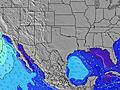 | 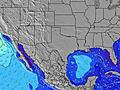 | 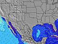 | 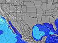 | 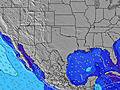 | 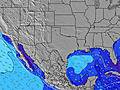 | 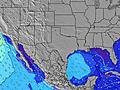 | 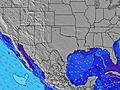 | |||||||||||||
Swell Altura (m) Direção Período (s) | SSE 5 | SSE 5 | SSE 5 | SSE 5 | SSE 5 | SSE 5 | SSE 5 | SSE 6 | SSE 6 | SSE 6 | SSE 6 | SSE 6 | SSE 5 | SSE 5 | SSE 5 | SSE 5 | SSE 6 | SSE 6 | SE 5 | SE 5 | SSE 5 |
Onda Gráfico | |||||||||||||||||||||
42 | 42 | 41 | 52 | 64 | 59 | 73 | 69 | 60 | 45 | 49 | 47 | 49 | 56 | 53 | 46 | 43 | 43 | 30 | 39 | 44 | |
Vento (km/h) | |||||||||||||||||||||
Estado do Vento maral cruzado-maral Cruzado cruzado-terral terral cristalino | cross-on | cross-on | cross-on | cross-on | cross-on | cross-on | cross-on | cross-on | cross-on | cross-on | cross-on | cross-on | cross-on | cross-on | cross-on | cross-on | cross-on | cross-on | cross-on | cross-on | cross-on |
Maré Alta | 1:34PM0.05m | 1:58PM0.04m | 1:41PM0.03m | ||||||||||||||||||
Maré Baixa | 2:23AM-0.09m | 2:55AM-0.07m | |||||||||||||||||||
6:48 | — | — | — | — | — | 6:50 | — | — | — | — | — | — | — | 6:50 | — | — | — | — | — | — | |
— | — | — | 8:20 | — | — | — | — | — | — | — | 8:20 | — | — | — | — | — | — | — | 8:19 | — | |
mm | — | — | — | — | — | — | — | — | — | — | — | — | — | — | — | — | — | — | — | — | — |
Temp. °C | 29 | 28 | 28 | 28 | 28 | 28 | 27 | 28 | 28 | 28 | 28 | 28 | 28 | 27 | 27 | 27 | 27 | 28 | 28 | 28 | 28 |
Ressent. °C | 31 | 28 | 28 | 28 | 29 | 29 | 28 | 31 | 30 | 29 | 29 | 29 | 30 | 28 | 29 | 30 | 29 | 30 | 30 | 30 | 30 |
Swell 1 Altura (m) Direção Período (s) | SE 9 | SE 9 | ESE 8 | — | ESE 8 | ESE 8 | SE 8 | SE 8 | SE 8 | SE 8 | ESE 8 | — | — | ESE 8 | SE 8 | SE 8 | SSE 6 | SSE 6 | SE 8 | — | — |
3 | 3 | 7 | — | 6 | 6 | 3 | 3 | 3 | 3 | 6 | — | — | 6 | 2 | 2 | 43 | 43 | 2 | — | — | |
Swell 2 Altura (m) Direção Período (s) | — | — | — | — | — | — | SE 6 | SE 6 | — | — | — | — | — | — | — | — | SE 8 | SE 7 | — | — | — |
— | — | — | — | — | — | 2 | 2 | — | — | — | — | — | — | — | — | 2 | 2 | — | — | — | |
Swell 3 Altura (m) Direção Período (s) | — | — | — | — | — | — | — | — | — | — | — | — | — | — | — | — | — | — | — | — | — |
— | — | — | — | — | — | — | — | — | — | — | — | — | — | — | — | — | — | — | — | — | |
Ondas de vento Altura (m) Direção Período (s) | SSE 5 | SSE 5 | SSE 5 | SSE 5 | SSE 5 | SSE 5 | SSE 5 | SSE 6 | SSE 6 | SSE 6 | SSE 6 | SSE 6 | SSE 5 | SSE 5 | SSE 5 | SSE 5 | — | — | SE 5 | SE 5 | SSE 5 |
42 | 42 | 41 | 52 | 64 | 59 | 73 | 69 | 60 | 45 | 49 | 47 | 49 | 56 | 53 | 46 | — | — | 30 | 39 | 44 | |
Terral ou glassy mais perto | |||||||||||||||||||||
Distância (km) | 1036 | 1139 | 1139 | 1137 | 1067 | 1063 | 1054 | 1036 | 1036 | 1054 | 1141 | 1133 | 1053 | 1049 | 1053 | 1036 | 1036 | 1133 | 1141 | 1133 | 1077 |
Melhor previsões de ondas em Texas | |||||||||||||||||||||
Melhor previsões de ondas em United States | |||||||||||||||||||||
Buscador de Ondas Global | |||||||||||||||||||||
- Map Icons:
 Break
Break Live Wave Height (m)
 Live Wind Speed (km/h)
 Surf Rating (10 Max)
 Ocean Swells (m)
- Wind Speed (km/h)
widget de graça do Surf-Forecast.com para o seu site
O relatório de surf / widget do tempo abaixo está disponível para incorporar em sites de terceiros gratuitamente e fornece um resumo das nossas JP Luby Pier surf tempo. Simplesmente pegar o trecho de código html que fornecemos e colá-lo em seu próprio site. Você pode escolher seu idioma preferido e unidades métrico/imperial para o surf tempo de alimentação para atender aos usuários do seu site.... Clique aqui para adquirir o código.
 Nearest