

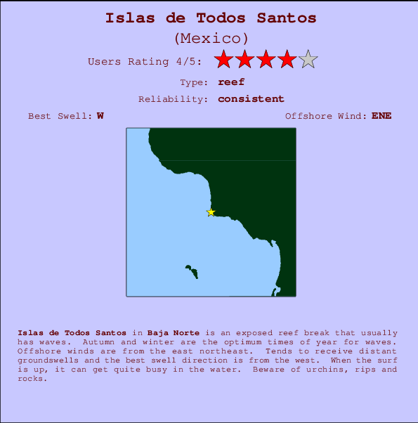
Islas de Todos Santos Surf Guide
Islas de Todos Santos in Baja Norte is an exposed reef break that usually has waves. Autumn and winter are the best times of year for waves. The best wind direction is from the east northeast. Groundswells more frequent than windswells and the ideal swell angle is from the west. Reef breaks provide lefts and rights. Sometimes crowded. Take care of urchins, rips and rocks.
Islas de Todos Santos Spot Info
| Type: | Rating: | Reliability: | Todays Sea Temp*: |
|---|---|---|---|
| consistent | 21.8°C*ocean temperature recorded from satellite |
Surfing Islas de Todos Santos:
The best conditions reported for surf at Islas de Todos Santos occur when a West swell combines with an offshore wind direction from the East-northeast.
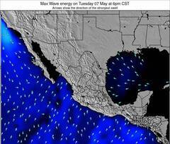
Previsão da Energia de Ondas (Força): 12hrs


Islas de Todos Santos Surf:
Saturday, 25 July 2026, 22:12 Local time| Sáb | Dom | |||
| 8PM | 11PM | 2AM | 5AM | |
| Wave (m) | ||||
| Período (s) | 20 | 19 | 19 | 19 |
| Vento (km/h) | ||||
| Estado do Vento | cross- on |
cross- on |
glass | glass |
- /breaks/Islasde-Todos-Santos/forecasts/latest
Islas de Todos Santos Surf Guide
Islas de Todos Santos in Baja Norte is an exposed reef break that usually has waves. Autumn and winter are the best times of year for waves. The best wind direction is from the east northeast. Groundswells more frequent than windswells and the ideal swell angle is from the west. Reef breaks provide lefts and rights. Sometimes crowded. Take care of urchins, rips and rocks.
Islas de Todos Santos Spot Info
Type: Rating: Reliability: Todays Sea Temp*:  Reef
Reef 4
4consistent 21.8°C*ocean temperature recorded from satelliteSurfing Islas de Todos Santos:
The best conditions reported for surf at Islas de Todos Santos occur when a West swell combines with an offshore wind direction from the East-northeast.
Previsão da Energia de Ondas (Força): 12hrs
Use a aba navegação acima para ver temperatura do mar em Islas de Todos Santos, fotografias de Islas de Todos Santos, previsões detalhadas do swell em Islas de Todos Santos, previsões do vento e do tempo, webcams em Islas de Todos Santos , vento atual em Baja Norte com base em dados ao vivo fornecidos por estações de meteorologia e previsões da maré em Islas de Todos Santos. O link para os mapas do swell em Mexico abrirá uma imagem ampliada monstrando Mexico e os mares próximos. Estes mapas do swell podem ser animados para mostrar diferentes componentes do swell, energia das ondas, período das ondas, altura das ondas, assim como previsões do vento e do tempo, observações em tempo real do estado do tempo e do mar graças às bóias de Mexico, navios passantes e estações de meteorologia presentes na costa. Cada uma das páginas de previsão para este surf break apresenta as ferramentas do buscador global e regional para localizar as melores condições de surf na área ao redor de Islas de Todos Santos.
Islas de Todos Santos Surf:
Saturday, 25 July 2026, 22:12 Local timeSáb Dom 8PM 11PM 2AM 5AM Wave (m) Período (s) 20 19 19 19 Vento (km/h) Estado do Vento cross-
oncross-
onglass glass - /breaks/Islasde-Todos-Santos/forecasts/latest
- /breaks/Islasde-Todos-Santos/forecasts/latest/six_day
Islas de Todos Santos Surf Guide
Islas de Todos Santos in Baja Norte is an exposed reef break that usually has waves. Autumn and winter are the best times of year for waves. The best wind direction is from the east northeast. Groundswells more frequent than windswells and the ideal swell angle is from the west. Reef breaks provide lefts and rights. Sometimes crowded. Take care of urchins, rips and rocks.
Islas de Todos Santos Spot Info
Type: Rating: Reliability: Todays Sea Temp*: Reef4consistent 21.8°C*ocean temperature recorded from satelliteSurfing Islas de Todos Santos:
The best conditions reported for surf at Islas de Todos Santos occur when a West swell combines with an offshore wind direction from the East-northeast.
Previsão da Energia de Ondas (Força): 12hrs
Use a aba navegação acima para ver temperatura do mar em Islas de Todos Santos, fotografias de Islas de Todos Santos, previsões detalhadas do swell em Islas de Todos Santos, previsões do vento e do tempo, webcams em Islas de Todos Santos , vento atual em Baja Norte com base em dados ao vivo fornecidos por estações de meteorologia e previsões da maré em Islas de Todos Santos. O link para os mapas do swell em Mexico abrirá uma imagem ampliada monstrando Mexico e os mares próximos. Estes mapas do swell podem ser animados para mostrar diferentes componentes do swell, energia das ondas, período das ondas, altura das ondas, assim como previsões do vento e do tempo, observações em tempo real do estado do tempo e do mar graças às bóias de Mexico, navios passantes e estações de meteorologia presentes na costa. Cada uma das páginas de previsão para este surf break apresenta as ferramentas do buscador global e regional para localizar as melores condições de surf na área ao redor de Islas de Todos Santos.
Islas de Todos Santos Surf:
Saturday, 25 July 2026, 22:12 Local timeSáb Dom 8PM 11PM 2AM 5AM Wave (m) Período (s) 20 19 19 19 Vento (km/h) Estado do Vento cross-
oncross-
onglass glass - /breaks/Islasde-Todos-Santos/forecasts/latest
Islas de Todos Santos Surf Guide
Islas de Todos Santos in Baja Norte is an exposed reef break that usually has waves. Autumn and winter are the best times of year for waves. The best wind direction is from the east northeast. Groundswells more frequent than windswells and the ideal swell angle is from the west. Reef breaks provide lefts and rights. Sometimes crowded. Take care of urchins, rips and rocks.
Islas de Todos Santos Spot Info
Type: Rating: Reliability: Todays Sea Temp*: Reef4consistent 21.8°C*ocean temperature recorded from satelliteSurfing Islas de Todos Santos:
The best conditions reported for surf at Islas de Todos Santos occur when a West swell combines with an offshore wind direction from the East-northeast.
Previsão da Energia de Ondas (Força): 12hrs
Use a aba navegação acima para ver temperatura do mar em Islas de Todos Santos, fotografias de Islas de Todos Santos, previsões detalhadas do swell em Islas de Todos Santos, previsões do vento e do tempo, webcams em Islas de Todos Santos , vento atual em Baja Norte com base em dados ao vivo fornecidos por estações de meteorologia e previsões da maré em Islas de Todos Santos. O link para os mapas do swell em Mexico abrirá uma imagem ampliada monstrando Mexico e os mares próximos. Estes mapas do swell podem ser animados para mostrar diferentes componentes do swell, energia das ondas, período das ondas, altura das ondas, assim como previsões do vento e do tempo, observações em tempo real do estado do tempo e do mar graças às bóias de Mexico, navios passantes e estações de meteorologia presentes na costa. Cada uma das páginas de previsão para este surf break apresenta as ferramentas do buscador global e regional para localizar as melores condições de surf na área ao redor de Islas de Todos Santos.
Islas de Todos Santos Surf:
Saturday, 25 July 2026, 22:12 Local timeSáb Dom 8PM 11PM 2AM 5AM Wave (m) Período (s) 20 19 19 19 Vento (km/h) Estado do Vento cross-
oncross-
onglass glass Tide Times:
Para El Sauzal %{dist} %{km} de %{location}
A PRÓXIMA É ÀS (hora local) faltam maré alta maré baixa Islas de Todos Santos Tide Times and Tide Chart
Live Weather:
At Tijuana International Airport, 72 km from Islas de Todos Santos.
light winds from the W
(km/h)Air temperature
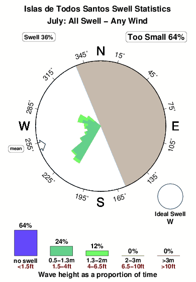
SKC°COverall Islas de Todos Santos Surf Consistency and Wind Distribution in Julho
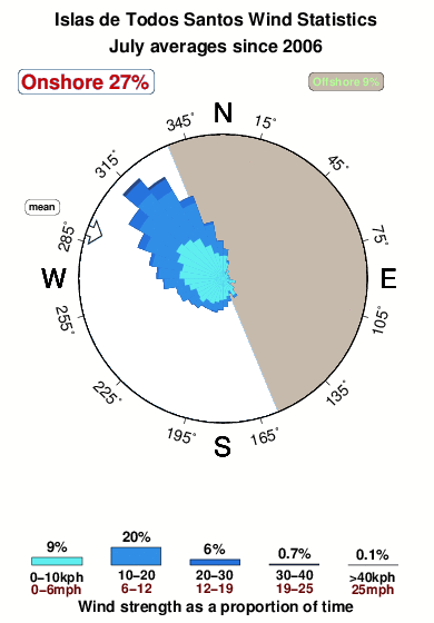


Wind stats for Islas de Todos Santos: see the variation in direction and stength by month.
fotos da galeria
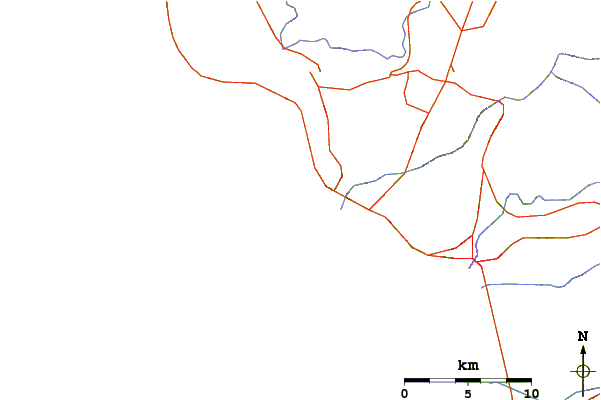
Contornos: Estradas & Rios: Escolha um spot de surf da lista 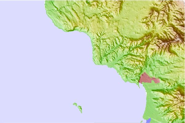
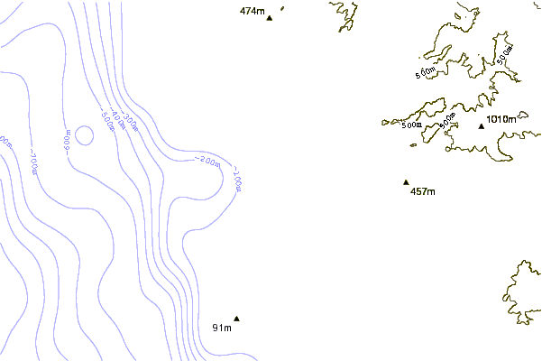
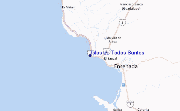
Use este mapa de relevo para navegar até Baja Norte surf quebras e estações que estão na área de maré Islas de Todos Santos
Outros Spots de Surf mais próximos de Islas de Todos Santos:
(Clique no nome do local para maiores detalhes)- Closest spot1 mi
- Second closest spot4 mi
- Third closest spot5 mi
- Fourth closest spot6 mi
- Fifth closest spot6 mi
Bóias ondográficas mais próxima de Islas de Todos Santos:
- Closest bóia ondográfica52 mi
- Second closest bóia ondográfica58 mi
- Third closest bóia ondográfica73 mi
- Fourth closest bóia ondográfica73 mi
- Fifth closest bóia ondográfica73 mi
Estações de maré mais próximo de Islas de Todos Santos:
- Closest estação de maréEl Sauzal4 mi
- Second closest estação de maréEnsenada8 mi
- Third closest estação de maréPrimo Tapia24 mi
- Fourth closest estação de maréRosarito34 mi
- Fifth closest estação de maréTijuana45 mi
Airports
- The closest passenger airport to Islas de Todos Santos is General Alberto L Salinas C International (Ensenada) Airport (ESE) in Mexico, 19 km (12 miles) away (directly).
- The second nearest airport to Islas de Todos Santos is General Abelardo L Rodriguez International (Tijuana) Airport (TIJ), also in Mexico, 73 km (45 miles) away.
- Third is North Island Nas (San Diego) Airport (NZY) in USA, 98 km (61 miles) away.
- San Diego International Lindbergh Fld Airport (SAN) in USA is 100 km (62 miles) away.
- Miramar Mcas Airport (NKX), also in USA is the fifth nearest airport to Islas de Todos Santos and is 113 km (70 miles) away.
- /breaks/Islasde-Todos-Santos/forecasts/latest
 Nearest