
Previsão:

Previsão de curto prazoprincipalmente seco. Warm (máx. 22°C na Sexta de manhã, mín 18°C na Sexta de noite). principalmente ventos frescos. | |||||||||||||||||||||
Sex 17 | Sábado 18 | Domingo 19 | |||||||||||||||||||
10 AM | 1 PM | 4 PM | 7 PM | 10 PM | 1 AM | 4 AM | 7 AM | 10 AM | 1 PM | 4 PM | 7 PM | 10 PM | 1 AM | 4 AM | 7 AM | 10 AM | 1 PM | 4 PM | 7 PM | 10 PM | |
Mapa da altura do Swell |  |  |  | 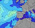 |  |  | 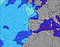 |  | |||||||||||||
Swell Altura (m) Direção Período (s) | W 6 | W 6 | W 6 | S 14 | S 14 | NNW 5 | NNW 6 | NNW 5 | NNW 5 | S 19 | S 19 | NW 5 | W 11 | S 12 | W 11 | W 10 | W 10 | W 9 | W 9 | W 9 | NNW 5 |
Onda Gráfico | |||||||||||||||||||||
3 | 3 | 1 | 4 | 4 | 0 | 0 | 0 | 0 | 7 | 7 | 0 | 2 | 3 | 2 | 2 | 8 | 7 | 7 | 6 | 0 | |
Vento (km/h) | |||||||||||||||||||||
Estado do Vento maral cruzado-maral Cruzado cruzado-terral terral cristalino | off | cross-off | cross-off | cross-off | off | off | off | off | off | cross-off | cross-off | cross-off | cross-off | off | off | off | off | cross-off | cross-off | cross-off | cross-off |
Maré Alta | 5:28PM3.09m | 5:57AM2.67m | 6:14PM2.93m | 6:42AM2.53m | 6:59PM2.71m | ||||||||||||||||
Maré Baixa | 11:08AM0.18m | 11:46PM0.10m | 11:52AM0.29m | 00:30AM0.26m | 12:37PM0.45m | ||||||||||||||||
6:28 | — | — | — | — | — | 6:28 | — | — | — | — | — | — | — | 6:28 | — | — | — | — | — | — | |
— | — | — | 8:53 | — | — | — | — | — | — | — | 8:52 | — | — | — | — | — | — | — | 8:52 | — | |
mm | — | — | — | — | — | — | — | — | — | — | — | — | — | — | — | — | — | — | — | — | — |
Temp. °C | 20 | 22 | 21 | 20 | 19 | 19 | 18 | 18 | 20 | 21 | 21 | 20 | 19 | 19 | 18 | 18 | 20 | 21 | 21 | 20 | 19 |
Ressent. °C | 18 | 19 | 17 | 15 | 15 | 15 | 15 | 15 | 17 | 18 | 17 | 16 | 15 | 16 | 15 | 15 | 17 | 18 | 17 | 16 | 16 |
Swell 1 Altura (m) Direção Período (s) | WNW 8 | WNW 8 | WNW 8 | WNW 8 | WNW 8 | WNW 8 | WNW 7 | WNW 8 | WNW 8 | WNW 8 | WNW 8 | — | WNW 8 | WNW 8 | WNW 8 | WNW 8 | W 10 | WNW 7 | W 9 | W 9 | WNW 9 |
13 | 13 | 13 | 13 | 13 | 6 | 11 | 12 | 14 | 7 | 7 | — | 6 | 6 | 6 | 6 | 8 | 5 | 7 | 6 | 15 | |
Swell 2 Altura (m) Direção Período (s) | W 6 | W 6 | W 6 | S 14 | S 14 | — | — | — | — | S 19 | S 19 | — | W 11 | W 11 | W 11 | NW 8 | NW 8 | W 9 | NW 10 | — | NNW 9 |
3 | 3 | 1 | 4 | 4 | — | — | — | — | 7 | 7 | — | 2 | 2 | 2 | 3 | 3 | 7 | 4 | — | 8 | |
Swell 3 Altura (m) Direção Período (s) | — | — | — | — | — | — | — | — | — | — | — | — | — | S 12 | N 11 | W 10 | W 8 | NW 8 | S 18 | — | — |
— | — | — | — | — | — | — | — | — | — | — | — | — | 3 | 2 | 2 | 4 | 3 | 6 | — | — | |
Ondas de vento Altura (m) Direção Período (s) | NW 4 | NW 4 | NW 4 | NW 4 | NNW 5 | NNW 5 | NNW 6 | NNW 5 | NNW 5 | NNW 4 | NNW 4 | NW 5 | NW 5 | NNW 5 | NNW 5 | NW 5 | NW 5 | NNW 5 | NW 5 | NW 5 | NNW 5 |
17 | 16 | 24 | 38 | 64 | 103 | 87 | 49 | 36 | 35 | 35 | 54 | 76 | 75 | 78 | 62 | 60 | 45 | 45 | 53 | 67 | |
Terral ou glassy mais perto | |||||||||||||||||||||
Distância (km) | 186 | 237 | 725 | 1214 | 1214 | 725 | 725 | 374 | 50 | 50 | 318 | 1194 | 893 | 726 | 481 | 399 | 239 | 238 | 382 | 660 | 726 |
Melhor previsões de ondas em The Algarve | |||||||||||||||||||||
Melhor previsões de ondas em Portugal | |||||||||||||||||||||
Buscador de Ondas Global | |||||||||||||||||||||
- Map Icons:
 Break
Break Live Wave Height (m)
 Live Wind Speed (km/h)
 Surf Rating (10 Max)
 Ocean Swells (m)
- Wind Speed (km/h)
widget de graça do Surf-Forecast.com para o seu site
O relatório de surf / widget do tempo abaixo está disponível para incorporar em sites de terceiros gratuitamente e fornece um resumo das nossas Ingrina surf tempo. Simplesmente pegar o trecho de código html que fornecemos e colá-lo em seu próprio site. Você pode escolher seu idioma preferido e unidades métrico/imperial para o surf tempo de alimentação para atender aos usuários do seu site.... Clique aqui para adquirir o código.
 Nearest