
Previsão:

Previsão de curto prazoprincipalmente seco. Warm (máx. 20°C na Terça à tarde, mín 11°C na Terça de manhã). Ventos aumentam (calmo no Domingo de manhã, ventos frescos de Este-Nordeste na Terça à noite). | |||||||||||||||||||||||
Domingo 26 | Segunda-feira 27 | Terça-feira 28 | |||||||||||||||||||||
5 AM | 8 AM | 11 AM | 2 PM | 5 PM | 8 PM | 11 PM | 2 AM | 5 AM | 8 AM | 11 AM | 2 PM | 5 PM | 8 PM | 11 PM | 2 AM | 5 AM | 8 AM | 11 AM | 2 PM | 5 PM | 8 PM | 11 PM | |
Mapa da altura do Swell |  |  | 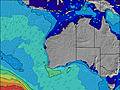 | 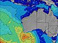 | 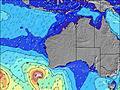 |  |  | 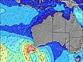 |  | ||||||||||||||
Swell Altura (m) Direção Período (s) | WSW 12 | WSW 12 | SW 16 | SW 16 | SW 16 | SW 15 | SW 15 | SW 14 | SW 14 | SW 14 | SW 14 | SW 13 | SW 13 | SW 12 | SW 12 | SW 13 | SW 13 | SW 15 | SW 15 | SW 14 | SW 14 | SW 14 | SW 14 |
Onda Gráfico | |||||||||||||||||||||||
273 | 226 | 291 | 295 | 291 | 544 | 767 | 1999 | 2358 | 2424 | 2096 | 1803 | 1619 | 1474 | 1379 | 1299 | 1380 | 1753 | 1760 | 1712 | 1602 | 1580 | 1480 | |
Vento (km/h) | |||||||||||||||||||||||
Estado do Vento maral cruzado-maral Cruzado cruzado-terral terral cristalino | glassy | off | glassy | on | on | cross | cross-off | cross-off | cross-off | cross-off | cross-off | cross-off | cross | cross-off | cross-off | cross-off | cross-off | cross-off | off | off | cross-off | cross-off | off |
Maré Alta | 6:53AM0.67m | 7:39AM0.69m | 8:21AM0.69m | ||||||||||||||||||||
Maré Baixa | 4:47PM0.07m | 5:11PM0.06m | 5:31PM0.06m | ||||||||||||||||||||
7:09 | — | — | — | — | — | — | — | 7:07 | — | — | — | — | — | — | — | 7:07 | — | — | — | — | — | — | |
— | — | — | — | 5:47 | — | — | — | — | — | — | — | 5:49 | — | — | — | — | — | — | — | 5:49 | — | — | |
mm | — | — | — | — | — | — | — | — | — | — | — | — | — | — | — | — | — | — | — | — | — | — | — |
Temp. °C | 17 | 17 | 19 | 19 | 19 | 16 | 16 | 15 | 14 | 14 | 16 | 18 | 18 | 16 | 15 | 14 | 12 | 11 | 15 | 19 | 20 | 17 | 17 |
Ressent. °C | 16 | 15 | 19 | 17 | 17 | 12 | 13 | 12 | 12 | 10 | 11 | 14 | 13 | 12 | 11 | 9 | 7 | 5 | 9 | 14 | 16 | 12 | 11 |
Swell 1 Altura (m) Direção Período (s) | WSW 12 | WSW 12 | WSW 12 | WSW 12 | SW 16 | SW 15 | SW 15 | SW 14 | SW 14 | SW 14 | SW 14 | SW 13 | SW 13 | SW 12 | SW 12 | SW 13 | SW 13 | SW 15 | SW 15 | SW 14 | SW 14 | SW 14 | SW 14 |
273 | 226 | 180 | 161 | 291 | 544 | 767 | 1999 | 2358 | 2424 | 2096 | 1803 | 1619 | 1474 | 1379 | 1299 | 1380 | 1753 | 1760 | 1712 | 1602 | 1580 | 1480 | |
Swell 2 Altura (m) Direção Período (s) | SW 16 | SW 16 | SW 16 | SW 16 | WSW 12 | SW 7 | SW 8 | — | — | — | — | — | — | — | — | SW 24 | SW 24 | SW 24 | WSW 22 | SW 21 | SW 21 | SW 21 | SW 20 |
169 | 201 | 291 | 295 | 177 | 14 | 30 | — | — | — | — | — | — | — | — | 22 | 22 | 22 | 48 | 117 | 117 | 115 | 192 | |
Swell 3 Altura (m) Direção Período (s) | — | — | — | — | — | — | — | — | — | — | — | — | — | — | — | — | — | — | — | — | — | — | — |
— | — | — | — | — | — | — | — | — | — | — | — | — | — | — | — | — | — | — | — | — | — | — | |
Ondas de vento Altura (m) Direção Período (s) | — | — | — | WSW 4 | SW 6 | S 4 | SSW 6 | — | — | — | — | — | — | — | ESE 3 | ESE 4 | ESE 4 | ESE 4 | E 4 | E 4 | — | — | — |
— | — | — | 2 | 16 | 27 | 86 | — | — | — | — | — | — | — | 7 | 8 | 16 | 14 | 9 | 4 | — | — | — | |
Terral ou glassy mais perto | |||||||||||||||||||||||
Distância (km) | 0 | 0 | 0 | 276 | 78 | 727 | 45 | 36 | 23 | 23 | 23 | 45 | 78 | 42 | 23 | 23 | 23 | 36 | 23 | 23 | 0 | 23 | 0 |
Melhor previsões de ondas em North West WA | |||||||||||||||||||||||
Melhor previsões de ondas em Australia | |||||||||||||||||||||||
Buscador de Ondas Global | |||||||||||||||||||||||
- Map Icons:
 Break
Break Live Wave Height (m)
 Live Wind Speed (km/h)
 Surf Rating (10 Max)
 Ocean Swells (m)
- Wind Speed (km/h)
widget de graça do Surf-Forecast.com para o seu site
O relatório de surf / widget do tempo abaixo está disponível para incorporar em sites de terceiros gratuitamente e fornece um resumo das nossas Horrocks surf tempo. Simplesmente pegar o trecho de código html que fornecemos e colá-lo em seu próprio site. Você pode escolher seu idioma preferido e unidades métrico/imperial para o surf tempo de alimentação para atender aos usuários do seu site.... Clique aqui para adquirir o código.
 Nearest