
Previsão:

Previsão de curto prazochuva moderada (total 13mm), mais intensa na Terça à noite. Warm (máx. 27°C na Quarta à tarde, mín 15°C na Quarta à noite). Ventos aumentam (vento fraco de Su-Sudoeste na Seg à noite, ventos frescos de Sul na Terça à noite). | |||||||||||||||||||||
Seg 20 | Terça-feira 21 | Quarta-feira 22 | |||||||||||||||||||
11 AM | 2 PM | 5 PM | 8 PM | 11 PM | 2 AM | 5 AM | 8 AM | 11 AM | 2 PM | 5 PM | 8 PM | 11 PM | 2 AM | 5 AM | 8 AM | 11 AM | 2 PM | 5 PM | 8 PM | 11 PM | |
Mapa da altura do Swell | 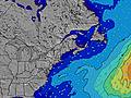 | 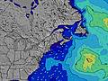 | 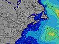 | 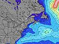 | 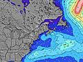 | 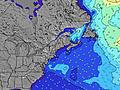 | 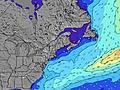 | 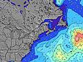 | |||||||||||||
Swell Altura (m) Direção Período (s) | SSE 8 | SSE 8 | SSE 4 | S 4 | S 5 | S 5 | S 4 | S 4 | SSE 4 | SSE 5 | SSE 5 | SSE 6 | SSE 6 | SSE 7 | SSE 7 | SSE 6 | SSE 7 | SSE 7 | SSE 8 | SSE 7 | SSE 7 |
Onda Gráfico | |||||||||||||||||||||
7 | 23 | 13 | 38 | 71 | 29 | 20 | 13 | 24 | 74 | 106 | 101 | 223 | 269 | 205 | 186 | 217 | 207 | 456 | 404 | 191 | |
Vento (km/h) | |||||||||||||||||||||
Estado do Vento maral cruzado-maral Cruzado cruzado-terral terral cristalino | off | cross | cross | cross | cross-off | cross-off | cross-off | cross | cross | cross-on | cross-on | cross-on | cross | cross-off | cross-off | cross-off | cross-off | cross | off | off | off |
Maré Alta | 4:48PM3.25m | 5:15AM2.98m | 5:40PM3.14m | 6:12AM2.81m | 6:32PM3.05m | ||||||||||||||||
Maré Baixa | 10:31AM0.55m | 11:06PM0.64m | 11:21AM0.76m | 00:03AM0.74m | 12:13PM0.92m | ||||||||||||||||
— | — | — | — | — | — | 5:22 | — | — | — | — | — | — | — | 5:22 | — | — | — | — | — | — | |
— | — | — | 8:15 | — | — | — | — | — | — | — | 8:15 | — | — | — | — | — | — | — | 8:14 | — | |
mm | — | — | — | — | — | — | — | — | — | — | — | 2 | 9 | 1 | — | — | — | — | 1 | — | — |
Temp. °C | 24 | 26 | 26 | 23 | 21 | 18 | 17 | 18 | 22 | 23 | 22 | 19 | 21 | 21 | 21 | 22 | 26 | 27 | 27 | 25 | 21 |
Ressent. °C | 22 | 23 | 22 | 20 | 18 | 16 | 16 | 17 | 19 | 19 | 19 | 17 | 18 | 21 | 21 | 23 | 25 | 26 | 28 | 23 | 19 |
Swell 1 Altura (m) Direção Período (s) | SSE 8 | SE 12 | SE 12 | SE 12 | E 12 | SE 8 | SE 8 | SE 8 | SE 12 | SE 12 | SE 11 | SE 11 | SE 11 | SE 11 | SE 11 | SE 6 | SSE 7 | — | SSE 8 | SSE 8 | SSE 7 |
7 | 6 | 6 | 6 | 3 | 3 | 3 | 3 | 5 | 5 | 5 | 5 | 5 | 5 | 5 | 149 | 116 | — | 253 | 294 | 191 | |
Swell 2 Altura (m) Direção Período (s) | SE 5 | SE 12 | SE 12 | SE 12 | SE 12 | E 12 | E 12 | S 7 | E 12 | — | — | — | — | — | — | SE 11 | ESE 8 | — | — | — | — |
1 | 6 | 6 | 6 | 6 | 3 | 3 | 1 | 3 | — | — | — | — | — | — | 5 | 22 | — | — | — | — | |
Swell 3 Altura (m) Direção Período (s) | SE 12 | SE 12 | — | — | S 12 | SE 12 | S 7 | E 12 | — | — | — | — | — | — | — | — | — | — | — | — | — |
6 | 6 | — | — | 3 | 5 | 1 | 3 | — | — | — | — | — | — | — | — | — | — | — | — | — | |
Ondas de vento Altura (m) Direção Período (s) | — | SSE 8 | SSE 4 | S 4 | S 5 | S 5 | S 4 | S 4 | SSE 4 | SSE 5 | SSE 5 | SSE 6 | SSE 6 | SSE 7 | SSE 7 | SSE 6 | SSE 7 | SSE 7 | SSE 8 | SSE 7 | — |
— | 23 | 13 | 38 | 71 | 29 | 20 | 13 | 24 | 74 | 106 | 101 | 223 | 269 | 205 | 186 | 217 | 207 | 456 | 404 | — | |
Terral ou glassy mais perto | |||||||||||||||||||||
Distância (km) | 228 | 255 | 619 | 492 | 492 | 492 | 492 | 1290 | 1290 | 1290 | 1290 | 531 | 805 | 805 | 199 | 0 | 199 | 199 | 0 | 0 | 0 |
Melhor previsões de ondas em New Hampshire | |||||||||||||||||||||
Melhor previsões de ondas em United States | |||||||||||||||||||||
Buscador de Ondas Global | |||||||||||||||||||||
- Map Icons:
 Break
Break Live Wave Height (m)
 Live Wind Speed (km/h)
 Surf Rating (10 Max)
 Ocean Swells (m)
- Wind Speed (km/h)
widget de graça do Surf-Forecast.com para o seu site
O relatório de surf / widget do tempo abaixo está disponível para incorporar em sites de terceiros gratuitamente e fornece um resumo das nossas Fox Hill Point surf tempo. Simplesmente pegar o trecho de código html que fornecemos e colá-lo em seu próprio site. Você pode escolher seu idioma preferido e unidades métrico/imperial para o surf tempo de alimentação para atender aos usuários do seu site.... Clique aqui para adquirir o código.
 Nearest