
Previsão:

Previsão de curto prazoChuva intensa (total 75mm), mais intensa durante Domingo à noite. Warm (máx. 28°C no Domingo à tarde, mín 25°C no Domingo à noite). Ventos diminuem (ventos frescos de Su-Sudoeste no Domingo à tarde, vento fraco de Su-Sudoeste na Terça à tarde). | |||||||||||||||||||
Sáb 1 | Domingo 2 | Segunda-feira 3 | |||||||||||||||||
5 PM | 8 PM | 11 PM | 2 AM | 5 AM | 8 AM | 11 AM | 2 PM | 5 PM | 8 PM | 11 PM | 2 AM | 5 AM | 8 AM | 11 AM | 2 PM | 5 PM | 8 PM | 11 PM | |
Mapa da altura do Swell |  |  | 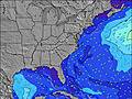 | 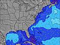 | 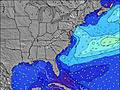 | 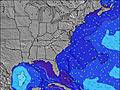 | 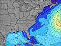 | ||||||||||||
Swell Altura (m) Direção Período (s) | SE 5 | SSE 5 | SE 5 | SSE 5 | SSE 5 | SSE 5 | SSE 6 | SSE 7 | SSE 7 | SSE 8 | S 8 | S 8 | S 8 | S 8 | S 7 | S 7 | S 7 | S 6 | S 6 |
Onda Gráfico | |||||||||||||||||||
31 | 40 | 35 | 44 | 41 | 70 | 119 | 0 | 0 | 0 | 0 | 0 | 0 | 0 | 0 | 0 | 0 | 0 | 0 | |
Vento (km/h) | |||||||||||||||||||
Estado do Vento maral cruzado-maral Cruzado cruzado-terral terral cristalino | cross-on | cross | cross | cross | cross-off | cross-off | cross-off | cross-off | cross-off | cross-off | cross-off | cross-off | cross-off | cross-off | cross-off | cross-off | cross-off | cross-off | cross-off |
Maré Alta | 9:41PM1.50m | 10:05AM1.40m | 10:16PM1.48m | 10:48AM1.44m | |||||||||||||||
Maré Baixa | 3:47PM0.11m | 4:17AM0.03m | 4:30PM0.14m | 4:52AM0.01m | 5:19PM0.19m | ||||||||||||||
— | — | — | — | 6:22 | — | — | — | — | — | — | — | 6:24 | — | — | — | — | — | — | |
— | 8:12 | — | — | — | — | — | — | — | 8:10 | — | — | — | — | — | — | — | 8:10 | — | |
mm | — | 2 | — | — | 1 | 3 | 2 | 3 | 2 | 1 | 2 | 5 | 7 | 6 | 5 | 7 | 7 | 1 | 4 |
Temp. °C | 28 | 27 | 27 | 27 | 27 | 27 | 27 | 28 | 27 | 27 | 27 | 26 | 25 | 26 | 25 | 25 | 25 | 26 | 26 |
Ressent. °C | 28 | 28 | 29 | 29 | 28 | 27 | 28 | 28 | 25 | 26 | 26 | 25 | 25 | 26 | 24 | 25 | 24 | 25 | 26 |
Swell 1 Altura (m) Direção Período (s) | — | ESE 9 | ESE 9 | ESE 8 | SE 8 | — | — | — | — | — | — | — | — | — | — | — | — | — | — |
— | 8 | 7 | 7 | 17 | — | — | — | — | — | — | — | — | — | — | — | — | — | — | |
Swell 2 Altura (m) Direção Período (s) | — | E 7 | — | E 6 | E 6 | — | — | — | — | — | — | — | — | — | — | — | — | — | — |
— | 1 | — | 1 | 1 | — | — | — | — | — | — | — | — | — | — | — | — | — | — | |
Swell 3 Altura (m) Direção Período (s) | — | — | — | — | — | — | — | — | — | — | — | — | — | — | — | — | — | — | — |
— | — | — | — | — | — | — | — | — | — | — | — | — | — | — | — | — | — | — | |
Ondas de vento Altura (m) Direção Período (s) | SE 5 | SSE 5 | SE 5 | SSE 5 | SSE 5 | SSE 5 | SSE 6 | SSE 7 | SSE 7 | SSE 8 | S 8 | S 8 | S 8 | S 8 | S 7 | S 7 | S 7 | S 6 | S 6 |
31 | 40 | 35 | 44 | 41 | 70 | 119 | 227 | 284 | 346 | 430 | 486 | 503 | 320 | 330 | 258 | 199 | 173 | 151 | |
Terral ou glassy mais perto | |||||||||||||||||||
Distância (km) | 806 | 806 | 1588 | 1221 | 1588 | 707 | 2020 | 707 | 576 | 572 | 685 | 547 | 989 | 380 | 337 | 380 | 525 | 559 | 290 |
Melhor previsões de ondas em North Carolina | |||||||||||||||||||
Melhor previsões de ondas em United States | |||||||||||||||||||
Buscador de Ondas Global | |||||||||||||||||||
- Map Icons:
 Break
Break Live Wave Height (m)
 Live Wind Speed (km/h)
 Surf Rating (10 Max)
 Ocean Swells (m)
- Wind Speed (km/h)
widget de graça do Surf-Forecast.com para o seu site
O relatório de surf / widget do tempo abaixo está disponível para incorporar em sites de terceiros gratuitamente e fornece um resumo das nossas Fort Fisher surf tempo. Simplesmente pegar o trecho de código html que fornecemos e colá-lo em seu próprio site. Você pode escolher seu idioma preferido e unidades métrico/imperial para o surf tempo de alimentação para atender aos usuários do seu site.... Clique aqui para adquirir o código.
 Nearest