
Previsão:

Previsão de curto prazochuva moderada (total 19mm), mais intensa na Terça à noite. Very mild (máx. 14°C na Terça de manhã, mín 8°C na Terça à noite). Ventos diminuem (near gales de Oeste-Sudoeste na Terça à noite, vento fraco de Oeste-Noroeste na Quinta à noite). | ||||||||||||||||||||||
Terça-feira 28 | Quarta-feira 29 | Quinta-feira 30 | ||||||||||||||||||||
7 AM | 10 AM | 1 PM | 4 PM | 7 PM | 10 PM | 1 AM | 4 AM | 7 AM | 10 AM | 1 PM | 4 PM | 7 PM | 10 PM | 1 AM | 4 AM | 7 AM | 10 AM | 1 PM | 4 PM | 7 PM | 10 PM | |
Mapa da altura do Swell |  |  |  | 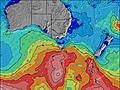 |  |  |  |  | ||||||||||||||
Swell Altura (m) Direção Período (s) | SW 13 | SW 13 | WSW 12 | WSW 12 | W 11 | WSW 10 | WSW 9 | WSW 12 | WSW 12 | SW 15 | SW 15 | SW 15 | SW 14 | SW 14 | SW 14 | SW 14 | SW 13 | SW 13 | SW 13 | SW 13 | SW 13 | SW 12 |
Onda Gráfico | ||||||||||||||||||||||
437 | 479 | 655 | 680 | 1868 | 1564 | 1519 | 4201 | 6952 | 12026 | 9937 | 7575 | 4968 | 3673 | 2982 | 911 | 1110 | 1326 | 1060 | 981 | 864 | 678 | |
Vento (km/h) | ||||||||||||||||||||||
Estado do Vento maral cruzado-maral Cruzado cruzado-terral terral cristalino | off | cross-off | cross-off | cross-off | cross | cross-off | cross-off | cross | cross-on | cross-on | cross-on | cross-on | cross-on | cross-on | cross-on | cross-on | cross-on | cross-on | cross | cross | cross | cross-on |
Maré Alta | 10:47AM0.64m | 9:52PM0.59m | 11:47AM0.66m | 11:00PM0.59m | 12:38PM0.68m | |||||||||||||||||
Maré Baixa | 4:33PM0.40m | 4:43AM0.18m | 5:41PM0.39m | 5:41AM0.17m | 6:40PM0.35m | |||||||||||||||||
7:22 | — | — | — | — | — | — | — | 7:22 | — | — | — | — | — | — | — | 7:22 | — | — | — | — | — | |
— | — | — | 5:23 | — | — | — | — | — | — | — | 5:24 | — | — | — | — | — | — | — | 5:24 | — | — | |
mm | — | — | — | — | 2 | 2 | — | 2 | 3 | 1 | 1 | 1 | 1 | 1 | — | — | — | — | 1 | 1 | 1 | 1 |
Temp. °C | 12 | 13 | 14 | 14 | 10 | 9 | 8 | 10 | 10 | 10 | 11 | 11 | 11 | 11 | 10 | 10 | 11 | 11 | 10 | 12 | 11 | 11 |
Ressent. °C | 3 | 3 | 4 | 4 | 0 | -1 | -3 | -1 | -1 | -1 | 0 | 1 | 3 | 3 | 2 | 4 | 5 | 6 | 4 | 6 | 5 | 7 |
Swell 1 Altura (m) Direção Período (s) | SW 13 | SW 13 | WSW 12 | WSW 12 | — | SW 15 | SW 15 | — | — | — | — | — | — | — | — | SW 14 | SW 13 | SW 13 | SW 13 | — | WSW 13 | SW 12 |
437 | 479 | 655 | 680 | — | 385 | 492 | — | — | — | — | — | — | — | — | 911 | 1110 | 1326 | 1037 | — | 623 | 678 | |
Swell 2 Altura (m) Direção Período (s) | — | — | SW 16 | SW 15 | — | — | — | — | — | — | — | — | — | — | — | — | — | — | — | — | — | — |
— | — | 165 | 276 | — | — | — | — | — | — | — | — | — | — | — | — | — | — | — | — | — | — | |
Swell 3 Altura (m) Direção Período (s) | — | — | — | — | — | — | — | — | — | — | — | — | — | — | — | — | — | — | — | — | — | — |
— | — | — | — | — | — | — | — | — | — | — | — | — | — | — | — | — | — | — | — | — | — | |
Ondas de vento Altura (m) Direção Período (s) | NW 5 | NW 6 | NW 6 | NW 6 | W 11 | WSW 10 | WSW 9 | WSW 12 | WSW 12 | SW 15 | SW 15 | SW 15 | SW 14 | SW 14 | SW 14 | SW 8 | SSW 7 | — | WSW 13 | SW 13 | SW 13 | — |
103 | 154 | 169 | 151 | 1868 | 1564 | 1519 | 4201 | 6952 | 12026 | 9937 | 7575 | 4968 | 3673 | 2982 | 403 | 142 | — | 1060 | 981 | 864 | — | |
Terral ou glassy mais perto | ||||||||||||||||||||||
Distância (km) | 229 | 229 | 223 | 463 | 146 | 463 | 463 | 283 | 445 | 445 | 351 | 825 | 122 | 122 | 131 | 77 | 77 | 58 | 122 | 118 | 117 | 109 |
Melhor previsões de ondas em East Coast of Victoria | ||||||||||||||||||||||
Melhor previsões de ondas em Australia | ||||||||||||||||||||||
Buscador de Ondas Global | ||||||||||||||||||||||
- Map Icons:
 Break
Break Live Wave Height (m)
 Live Wind Speed (km/h)
 Surf Rating (10 Max)
 Ocean Swells (m)
- Wind Speed (km/h)
widget de graça do Surf-Forecast.com para o seu site
O relatório de surf / widget do tempo abaixo está disponível para incorporar em sites de terceiros gratuitamente e fornece um resumo das nossas Eagles Nest surf tempo. Simplesmente pegar o trecho de código html que fornecemos e colá-lo em seu próprio site. Você pode escolher seu idioma preferido e unidades métrico/imperial para o surf tempo de alimentação para atender aos usuários do seu site.... Clique aqui para adquirir o código.
 Nearest